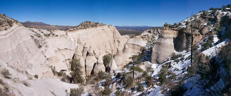
Kasha-Katuwe Tent Rocks National Monument

View to east from the top of the slot canyon with the Truchas Peaks in the distance
Image taken:
2005
by: Adam Read
©
2005
Adam Read
Longitude: -106.41276
Latitude: 35.66711
(WGS 84 or NAD 83)
About this image
Kasha-Katuwe Tent Rocks National Monument is on the southeast side of the Valles and Toledo calderas, large collapse features that formed during voluminous eruptions in the Jemez Mountain volcanic field 1.61 and 1.25 million years ago. Tent Rocks encompasses a fascinating landscape in the southeastern Jemez Mountains. Kasha-Katuwe means 'white cliffs' in Keresan, the traditional language of the nearby Pueblo de Cochiti. Delicately layered sand, gravel, volcanic ash, and tuff of the Peralta Tuff Member of the Bearhead Rhyolite and sand and gravel of the Cochiti Formation, which are older units (2 to 6 Ma) in the Jemez Mountain volcanic field, have been eroded into fragile to robust spires with balanced rocks perched on top. The hoodoos, erosional cones, and pedestal rocks that characterize Tent Rocks form as the result of differential erosion (Smith, 1996). Water and, to a lesser extent, wind erosion preferentially attacks the moderately-indurated sand and ash grains around the base of large blocks in the gravel-rich beds. Eventually, the gravel clasts rest on pedestals, thus protecting the underlying sand and ash from further erosion. As time passes, the capstones are gradually undermined and the rocks topple, leaving an unprotected cone.
— Shari A. Kelley
Location
Kasha-Katuwe Tent Rocks National Monument is located approximately 40 miles southwest of Santa Fe and 55 miles northeast of Albuquerque. From Albuquerque, drive north on Interstate-25 to Exit 259 to the Santo Domingo/Cochiti Lake Recreation Area. Head northwest on NM Highway 22 and follow the signs to Cochiti Pueblo (turning left after crossing the Rio Grande). Turn right at the pueblo water tower onto Tribal Route 92, which connects to Forest Service Road 266. Travel 5 miles on a maintained, but often washboard, dirt road to the monument parking area (marked with a sign). From Santa Fe, take the Cochiti Pueblo (Exit 264) off I-25 onto NM 16. Turn right from NM 16 onto NM 22, and follow the route described above to Cochiti Pueblo and the national monument. The BLM charges a fee to park here (paid at a self-service kiosk).
Image posted: 12-17-2021


