


Kasha-Katuwe Tent Rocks National Monument
We are a research and service division of:
Location
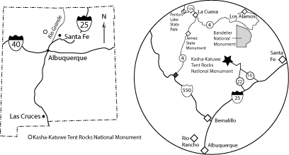
Kasha-Katuwe Tent Rocks National Monument, managed by the Bureau of Land Management (BLM), is located approximately 40 miles southwest of Santa Fe and 55 miles northeast of Albuquerque (Figure1). From Albuquerque, drive north on Interstate-25 to Exit 259 to the Santo Domingo/Cochiti Lake Recreation Area. Head northwest on NM Highway 22 and follow the signs to Cochiti Pueblo (turning left after crossing the Rio Grande). Turn right at the pueblo water tower onto Tribal Route 92, which connects to Forest Service Road 266. Travel 5 miles on a maintained, but often washboard, dirt road to the monument parking area (marked with a sign). From Santa Fe, take the Cochiti Pueblo (Exit 264) off I-25 onto NM 16. Turn right from NM 16 onto NM 22, and follow the route described above to Cochiti Pueblo and the national monument. The BLM charges a fee to park here (paid at a self-service kiosk).
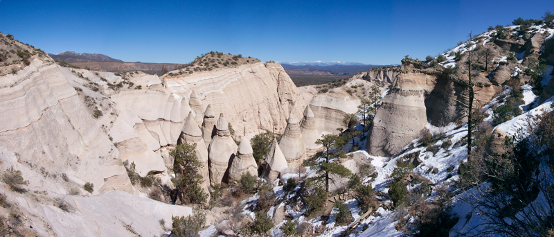
photo: © Adam Read
Introduction
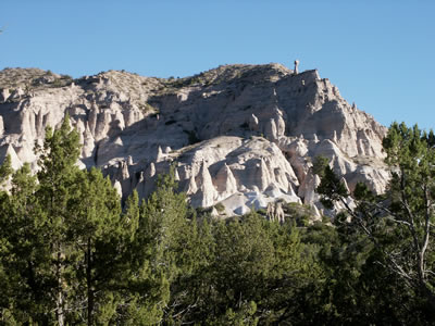
Kasha-Katuwe Tent Rocks National Monument is on the southeast side of the Valles and Toledo calderas, large collapse features that formed during voluminous eruptions in the Jemez Mountain volcanic field 1.61 and 1.25 million years ago. Tent Rocks encompasses a fascinating landscape in the southeastern Jemez Mountains. Kasha-Katuwe means 'white cliffs' in Keresan, the traditional language of the nearby Pueblo de Cochiti. Delicately layered sand, gravel, volcanic ash, and tuff of the Peralta Tuff Member of the Bearhead Rhyolite and sand and gravel of the Cochiti Formation, which are older units (2 to 6 Ma) in the Jemez Mountain volcanic field, have been eroded into fragile to robust spires with balanced rocks perched on top (Figures 2 and 3). The hoodoos, erosional cones, and pedestal rocks that characterize Tent Rocks form as the result of differential erosion (Smith, 1996). Water and, to a lesser extent, wind erosion preferentially attacks the moderately-indurated sand and ash grains around the base of large blocks in the gravel-rich beds. Eventually, the gravel clasts rest on pedestals, thus protecting the underlying sand and ash from further erosion. As time passes, the capstones are gradually undermined and the rocks topple, leaving an unprotected cone.
Regional Setting
Kasha-Katuwe Tent Rocks National Monument lies on the southeastern margin of the Jemez volcanic field, a volcanic system that has been active for the past 15 million years. The volcanic field formed at the intersection of the Rio Grande rift, an extensional feature that bisects the state of New Mexico, and the Jemez lineament, an ancient northeast-trending structure that has been a locus of volcanism for the last 10 million years.
Geology of the Tent Rocks Area
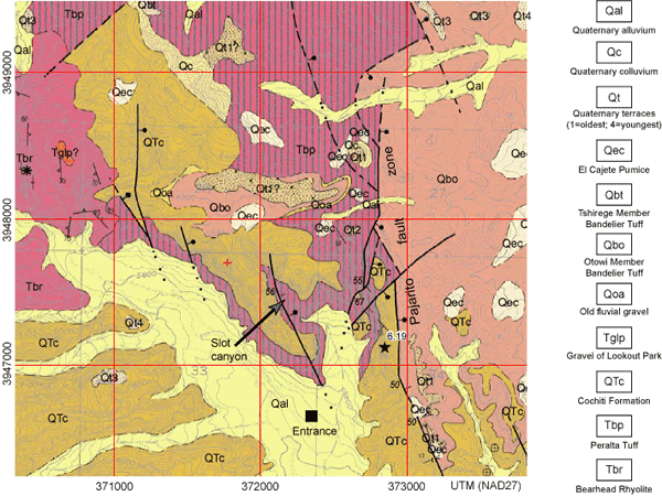
Two main rock units are exposed in the monument. The older unit is the white to orangish-tan Peralta Tuff Member of the Bearhead Rhyolite and the younger unit is the gray Cochiti Formation. The uppermost part of the Peralta Tuff and the Cochiti Formation are exposed near the parking lot at Tent Rocks, while lower Perlata Tuff is exposed on the northwest side of a down-to-the-southeast splay of the Pajarito Fault zone in the slot canyon on the northeast portion of the monument (Smith et al., 1991; Smith, 1996). The Peralta Tuff was deposited during an episode of intense rhyolitic volcanism in the Jemez Mountains 6.5 to 7 million years ago (Justet and Spell, 2001). At least twenty vents that extruded rhyolite domes and flows (Bearhead Rhyolite) have been identified in the southern Jemez Mountains (Smith, 1996), and several more vents have been recognized in the northeast wall of the Valles caldera and in the northern Jemez Mountains (Loeffler, 1988; Kempter et al., 2004, Gardner et al., 2006). The distribution of the Bearhead Rhyolite suggests that a magma chamber comparable in size to the chamber that created the Quaternary Valles and Toledo calderas lay beneath the Jemez Mountains in late Miocene time (Justet and Spell, 2001). Justet and Spell (2001) speculate that a caldera did not form in late Miocene time because extensional faulting associated with the Rio Grande rift may have kept the system vented, preventing the buildup of fluid and gas pressure that often triggers caldera eruptions.
Approximately 35 eruptive events are recorded in the Peralta Tuff in the vicinity of Tent Rocks (Smith, 1996). Pumice and ash-fall layers derived from distant vents are the most common indication of these events; however, 14 tuffs that erupted from nearby sources, including Bearhead Peak, the prominent peak located about 5 miles to the northeast, are also preserved in the section at Tent Rocks. The tuffs and tephras are interbedded with sand, gravel, reworked tuff, and ancient soil horizons (Smith and Katzman, 1991). The more coarse-grained Cochiti Formation overlies the relatively fine-grained Peralta Tuff. The glassy rhyolite and pumice in the Peralta Tuff gives way to devitrified rhyolite clasts in the Cochiti Formation, which causes the Cochiti Formation to have a gray color. Devitrification is a process whereby glass is transformed into crystalline minerals. The Cochiti Formation contains very few tephras compared to the Peralta Tuff. Smith et al. (1991) and Smith (1996, 2001) interpret this upsection change in clast composition and grain size to mark the time that erosion breached the cores of the Bearhead Rhyolite domes after rhyolitic volcanism waned about 6.5 million years ago.
"Apache tears," which are small, rounded pieces of obsidian, are common at Tent Rocks. DO NOT collect them! The obsidian is coming out of glassy clasts in the gravels in the Peralta Tuff and the Cochiti Formation. Groundwater moving through the sediments is hydrating the glass, causing black obsidian to become gray perlite. Often the clasts are not completely hydrated, leaving a core of obsidian surrounded by perlite. The obsidian is easily removed from the fractured perlite by erosion, which results in a concentration of tear-drop shaped obsidian pieces in drainage bottoms.
References
- Gardner, J.N., Goff, F., Reneau, S.L., Sandoval, M.M., Drakos, P.G., Katzman, D., and Goff, C.J., 2006, Preliminary geologic map of the Valle Toledo quadrangle, Los Alamos and Sandoval Counties, New Mexico, New Mexico Bureau of Mines and Mineral Resources, Open-file Geologic Map OF-GM 133, scale 1:24,000.
- Justet, L. and Spell, T.L., 2001, Effusive eruptions from a large silicic magma chamber: The Bearhead Rhyolite, Jemez volcanic field, N.M.: Journal of Volcanology and Geothermal Research, v.107, p. 241-264.
- Loeffler, B.M., Vaniman, D.T., Baldridge, W.S., and Shafiqullah, M., 1988, Neogene rhyolites of the northern Jemez volcanic field, New Mexico, Journal of Geophysical Research, 93(B6); 6157-6168.
- Lynch, S. D.; Smith, G. A.; Kuhle, A. J., 2004, Preliminary geologic map of the Canada 7.5-minute quadrangle, Sandoval County, New Mexico: New Mexico Bureau of Geology and Mineral Resources, Open-file Geologic Map OF-GM 85, scale 1:24,000
- Kempter, K.A., Kelley, S.A., Kelley, S.B., and Rampey, M., 2004, Preliminary geologic map of the Polvadera Peak 7.5-minute quadrangle, Rio Arriba County, New Mexico, New Mexico Bureau of Geology and Mineral Resources, Open-file Geologic Map OF-GM 96, scale 1:24,000.
- Smith, G.A., 1996, The geology of Tent Rocks: New Mexico Geological Society Guidebook 47, p. 89-90.
- Smith, G.A., 2001, Development of a pyroclastic apron adjacent to rhyolite domes in a subsiding basin: Upper Miocene Peralta Tuff, Jemez Mountains, New Mexico in Volcanoes of New Mexico, L. Crumpler, editor, New Mexico Museum of Natural History and Science Bulletin.
- Smith, G.A., and D. Katzman, 1991, Discrimination of eolian and pyroclastic-surge processes in the generation of cross-bedded tuffs, Jemez Mountains volcanic field, New Mexico: Geology, v. 19, p. 465-468.
- Smith, G.A., Larsen, D., Harlan, S.S., Mclntosh, W.C., Erskine, D.W., and Taylor, S., 1991, A tale of two vol-caniclastic aprons: Field guide to the sedimentology and physical volcanology of the Oligocene Espinaso Formation and Miocene Peralta Tuff, north-central New Mexico: New Mexico Bureau of Mines and Mineral Resources, Socorro, Bulletin 137, p. 87-103.