


GM-55—Geology of Pueblo Viejo Mesa quadrangle, Socorro and Cibola Counties, New Mexico
We are a research and service division of:
By J. C. Osburn, 1984, lat 34°30' to 34°37'30", long 107°30' to 107°37'30", reprinted and revised 1987, scale 1:24,000, 1 sheet approximately 8" x 10½".
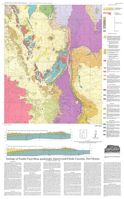
Recent work in Pueblo Viejo Mesa quadrangle has shown that the members of the Tres Hermanos Formation were mapped incorrectly in the central part of the quadrangle and that poor but mapable outcrops of the Rio Salado Tongue of the Mancos Shale are exposed in the same area. These errors were corrected during recent mapping as shown in this updated version of the area. This four-color revision is provided as a free insert with the purchase of GM-55, as well as being available to those who have purchased the map sheet since its release in 1984. Pueblo Viejo Mesa is located approximately 30 miles northwest of Magdalena. The study area lies in the Datil-Mogollon subprovince, a transition zone between the Basin and Range province and the Colorado province. The landscape is dominated by basalt-capped mesas and broad alluvial valleys.content.
$6.00
Buy
Now
Also available as a free download.
Download
| File Name | Size | Last Modified |
|---|---|---|
| GM-55_complete.zip | 17.55 MB | 02/05/2021 03:45:02 PM |
| GM-55_discussion.pdf | 5.96 MB | 02/05/2021 03:44:00 PM |
| GM-55_map-revision.pdf | 942 KB | 02/05/2021 03:44:55 PM |
| GM-55_map.pdf | 11.35 MB | 02/05/2021 03:44:28 PM |
| TIFF: | ||
| GM-55_map-pal.tif | 20.85 MB | 09/10/2018 03:34:24 PM |
| GM-55_map-revision-pal.tif | 2.42 MB | 09/10/2018 03:43:16 PM |
| GM-55_map-revision.tif | 15.55 MB | 09/10/2018 03:42:53 PM |
| GM-55_map.tif | 139.88 MB | 09/10/2018 03:29:53 PM |