


Open-file Geologic Map - 272
Geologic Map of the Laguna 7.5-Minute Quadrangle, Cibola County, New Mexico
Colin T. Cikoski, Paul G. Drakos, and James Riesterer
2018
(last revised: 5-July-2018)
scale 1 : 24,000
https://doi.org/10.58799/OF-GM-272
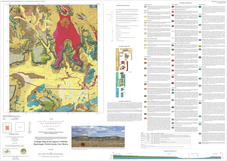
The Laguna quadrangle lies approximately 30 kilometers (km) east-southeast of the town of Grants and 60 km west of the city of Albuquerque along I-40 in northwestern New Mexico. Nearly the entire quadrangle lies on Pueblo of Laguna land, with small areas along the west margin of the quadrangle lying within the Cubero Land Grant. The small towns of Laguna, Encinal, Casa Blanca, and Paraje lie within the quadrangle extent. The Rio San Jose valley trends east-west across the southern half of the quadrangle. North of the river valley, a set of high basalt-capped mesas including Silver Dollar Mesa, Frog Mesa, and Clay Mesa extend southward from the Mount Taylor area as narrow topographic prongs that form escarpments above deep river valleys. South of the Rio San Jose valley, much lower sandstone-capped mesas such as Seama Mesa and Casa Blanca Mesa form local topographic highs above broad alluvial valleys. Elevations range from about 2,195 meters (m) above mean sea level (amsl) on Silver Dollar Mesa at the north-central edge of the quadrangle to 1,750 m amsl where the Rio San Jose exists the quadrangle.
Geologically, the quadrangle lies in the Acoma Sag section of the Colorado Plateau, east of the McCartys syncline and approximately 20 km west of the Lucero uplift and Rio Puerco fault zone, which demarcates the edge of the Colorado Plateau where the Plateau abuts the Rio Grande rift (Woodward, 1982). The Jemez lineament trends east-northeast through or just north of the quadrangle, and in Jurassic time the area was along the northern margin of the Mogollon Highland (Moench and Schlee, 1967). Volcanic fields lie to the north (Mount Taylor volcanic field), west (Zuni-Bandera volcanic field), and northeast (Rio Puerco volcanic necks), while deformations, generally of low magnitude, from Jurassic through at least middle Cenozoic time are evident. The majority of the quadrangle is underlain by clastic sedimentary rocks of Mesozoic age often blanketed by a variable thickness of Quaternary sediments. Plio-Pleistocene basalts locally uphold high mesas and crop out around the town of Laguna. Structural relief is generally low.
Downloads
| File Name | Size | Last Modified |
|---|---|---|
| OFGM-272_Laguna.pdf | 3.45 MB | 02/19/2021 02:34:24 PM |
| OFGM-272_LagunaReport.pdf | 6.71 MB | 02/19/2021 02:34:35 PM |
| GISdata: | ||
| OFGM-272_Laguna.mpk | 87.44 MB | 07/05/2018 09:59:08 AM |
Notes:
Geologic mapping of this and other 7½-minute quadrangles in New Mexico is being cooperatively funded by the USGS through the STATEMAP program and with matching funds from the Bureau. For a list of quadrangles in this series, please visit the Open-file Geologic Map (OF-GM) page or try our search page for geologic maps of any series.
These maps are open-filed as they become available. Initially, maps are posted as PDF files of scans of the hand-drawn linework, and later as full color maps and GIS products. These files can be downloaded for free or may be purchased on CD-ROM.
These maps are subject to frequent revisions and may be unavailable when being revised. Map Reference dates show the time of initial compilation; Map Revision dates, when given, indicate the most current version of the map; Last Modified dates for files may not accurately reflect the time the map was last revised.
Please direct comments or requests regarding these maps to either the map authors or the Geologic Mapping Program Manager.