


Open-file Geologic Map - 298
Geology of the Los Alamos 30 x 60-Minute Quadrangle Study Area, Los Alamos, Santa Fe, and Sandoval Counties, New Mexico
Shari A. Kelley, Fraser Goff, Phil L. Miller, David A. Sawyer, Daniel J. Koning, Ren A. Thompson, Gary A. Smith, Scott A. Minor, Karl S. Kellog, Adam S. Read, Tyler Askin, Matthew J. Zimmerer, and Andrew P. Jochems
2023
(last revised: 31-March-2023)
scale 1 : 24,000
https://doi.org/10.58799/OF-GM-298
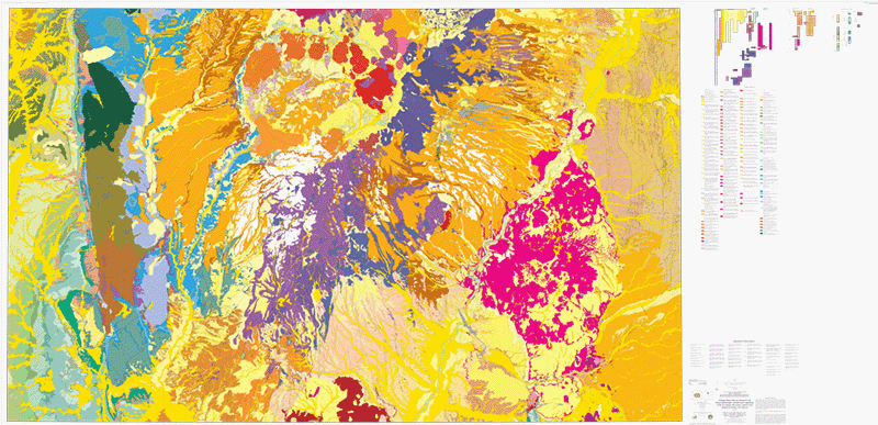
This publication captures the geology of the Los Alamos 30 x 60-minute quadrangle at two scales: 1:24,000 (complete and published) and 1:100,000 (pending completion and publication). The 1,24,000 product is intended as a data release only and the pdf is for quick reference and not the typical NMBGMR cartographic product. The 1:100,000 products will be a GIS data release and a typical full cartographic pdf.
Downloads
| File Name | Size | Last Modified |
|---|---|---|
| LosAlamos24k.pdf | 38.09 MB | 03/29/2023 09:32:29 AM |
| LosAlamos24K_Report.pdf | 1.17 MB | 03/29/2023 09:32:34 AM |
| GISdata: | ||
| LosAlamos 30x60 Quadrangle at 24000 scale: | ||
| LosAlamos24k.mpk | 92.11 MB | 03/28/2023 01:23:22 PM |
Notes:
Geologic mapping of this and other 7½-minute quadrangles in New Mexico is being cooperatively funded by the USGS through the STATEMAP program and with matching funds from the Bureau. For a list of quadrangles in this series, please visit the Open-file Geologic Map (OF-GM) page or try our search page for geologic maps of any series.
These maps are open-filed as they become available. Initially, maps are posted as PDF files of scans of the hand-drawn linework, and later as full color maps and GIS products. These files can be downloaded for free or may be purchased on CD-ROM.
These maps are subject to frequent revisions and may be unavailable when being revised. Map Reference dates show the time of initial compilation; Map Revision dates, when given, indicate the most current version of the map; Last Modified dates for files may not accurately reflect the time the map was last revised.
Please direct comments or requests regarding these maps to either the map authors or the Geologic Mapping Program Manager.