


Storrie Lake State Park
We are a research and service division of:
Introduction
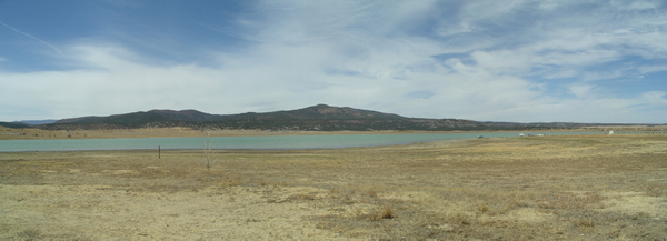
Storrie Lake State Park is located four miles north of Las Vegas, New Mexico, and can be reached via New Mexico Highway 518. The 1400-foot long earthen dam that retains the water in Storrie Lake was built under the direction of Robert C. Storrie starting in 1916 (Bejnar, 1981). The project was not completed until 1921 due to cash and labor shortages. Water from the Gallinas River, a southeasterly-flowing river with its headwaters in the Sangre de Cristo Mountains and the main water supply for the community of Las Vegas, is diverted for storage in Storrie Lake. This lake is an integral part of an irrigation system for Las Vegas and surrounding areas. Originally, between 1922 and 1945, the Storrie Lake Irrigation Project supported vegetable crops; however, the climate around Las Vegas was found to be unsuitable for crops of this type. The water is now used to support wildlife at the Las Vegas National Wildlife Refuge located 8 miles southeast of Las Vegas.
Geology of the Park
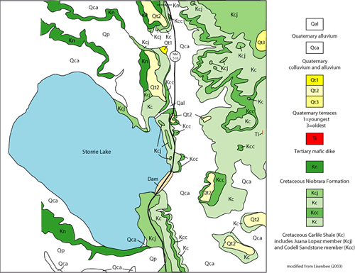
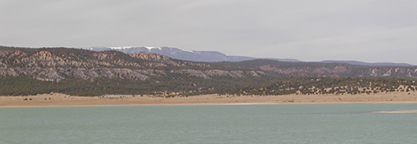
The Cretaceous Carlile Shale and Niobrara Formation are the main rock types exposed in the immediate vicinity of the lake (Figures 1, 2, and 3). These units, composed of interbedded black shale, light brown siltstone to sandstone, and gray limestone (Figure 1), were deposited 85 to 95 million years ago when this area was covered by the Western Interior Seaway. The shallow ocean teemed with life; fossil oysters (Ostrea), clams (Innocermous), snails (Turritella), ammonites, and brachiopods, as well as shark and skate teeth, are often found around the lake (Lessard, 1976; Bejnar, 1981). Lisenbee (2003) separated out two subunits in the Carlile Shale around Storrie Lake, the Codell Sandstone Member and the Juana Lopez Member (Figure 3). The Codell Sandstone is an orange brown-weathering sandstone with septarian limestone and boulder-size, yellow, silty-limestone concretions (Skotnicki, 2003). The Juana Lopez Member is characterized by very fossiliferous, thin, limestone beds interbedded with thin gray shale and white bentonite (ash) beds (Skotnicki, 2003); limestone concretions are relatively rare in this unit. Carlile Shale, a gray shale with rare siltstone beds and cobble-sized limestone concretions, occurs above and below the Codell Sandstone Member. The Carlile Shale is overlain by the Niobrara Formation, consisting of interbedded black shale, brown siltstone, and gray limestone (Baltz, 1972).
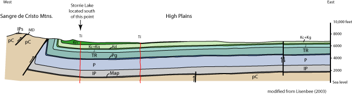
Regional Geologic Setting
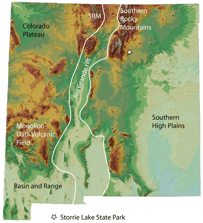
Storrie Lake State Park lies on the boundary between two important physiographic provinces, the Southern High Plains and the Southern Rocky Mountains (Figure 4). The lake is on the High Plains just east of the Rincon Range portion of the Sangre de Cristo Mountains, a sub-province of the Southern Rocky Mountains. The Rio Grande rift, a northerly-trending zone of continental extension that runs from northern Colorado to west Texas, marks the western boundary of the Sangre de Cristo Mountains (Figure 4). The Rincon Range, which is cored by Proterozoic basement and Paleozoic sedimentary rocks, is bound on the south by Romero Gap, on the east by the Southern High Plains, and on the west by the Picuris-Pecos Fault just west of the Pecos River (Figure 5). At least four episodes of mountain building are recorded in the Sangre de Cristo Mountains.
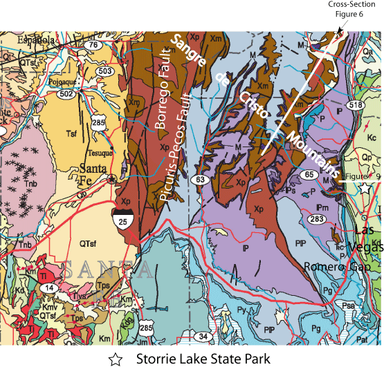
Geology of the Rincon Range
The oldest rocks in the Sangre de Cristo Mountains are Proterozoic metavolcanic and metasedimentary rocks that are preserved in several places throughout the range (Xm on Figure 5), including along NM Highway 65 to the west of the park (Figure 5; Baltz, 1972, Read et al., 1999). These rocks originally were volcanic rocks (basalts and rhyolites), sandstone, and shale deposited in a basin about 1.7 billion years ago. These volcanic and sedimentary rocks were buried, deformed, and heated by granitic intrusions during a mountain building event about 1.68 to 1.65 billion years ago related to the southward growth of North America as island arcs were accreted onto the southern margin of the continent (Figure 6, Read et al., 1999; Karlstrom et al., 2004). The combination of high temperatures and high pressures at great depth in the Earth transformed the volcanic and sedimentary rocks into metavolcanic and metasedimentary rocks. The Rincon Range lies just north of a profound crustal boundary known as the Jemez lineament that marks the southern extent of 1.7 billion year old rocks in New Mexico (Karlstrom et al., 2004). The rocks of the Rincon Range were heated by granitic intrusion (Hermit's Peak batholith, Figure 6) again about 1.4 billion years ago (Read et al., 1999).
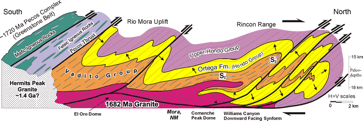
By about 345 million years ago, the deeply buried Proterozoic rocks were brought back at the Earth's surface by uplift and erosion (Baltz and Myers, 1999), where they were covered by rocks deposited in a shallow ocean during late Mississippian time. Mississippian sandstone and limestone can be seen sitting on the metamorphic rocks. Locally, the Mississippian rocks are missing and Pennsylvanian rocks that were deposited in a shallow ocean rest directly on the Proterozoic rocks. This is a classic example of the Great Unconformity. As much as 1.39 billion years of Earth's history is missing across this boundary!
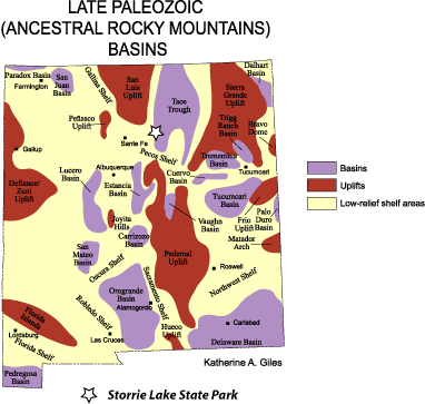
Starting about 315 million years ago, the area now occupied by the Rincon Range was in the Taos Trough, on the southeastern margin of an Ancestral Rocky Mountain highland called the San Luis uplift (Figure 7 ; Baltz and Myers, 1999; Kues and Giles, 2004). Ancestral Rocky Mountain deformation across the southwestern United States is characterized by north- and northwest-trending uplifts separated by intervening basins that are filled with both marine sediments and sediments shed from the adjacent uplifts. Detritus eroded from the San Luis mountain range was shed eastward into a basin east of the Picuris-Pecos fault, the Taos Trough. This phase of mountain building waned about 280 million years ago (Baltz and Myers, 1999).
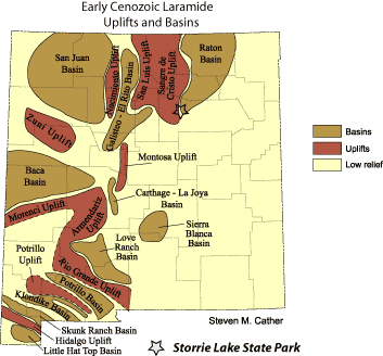
The Rincon Range was likely tectonically quiet between 280 and ~70 million years ago, which allowed the deposition of the Permian to early Cretaceous sedimentary rocks preserved in the nearly vertical hogbacks just west of the state park along Highway 65 (Baltz, 1972; Lessard and Bejnar, 1976). As mentioned above, the shales, limestones, and sandstones at Storrie Lake State Park were deposited by the Cretaceous Western Interior Seaway during Middle to Late Cretaceous time. Starting about 70 million years ago, a significant compressive mountain building event, the Laramide orogeny, strongly deformed the Late Cretaceous and older rocks just west of the park, causing the Rincon Range to rise again (Figure 8). Proterozoic rocks were thrust over younger sedimentary rocks along west-dipping faults by Laramide deformation, causing sharp folding of the younger rocks and formation of a pronounced hogback (Figure 9).
The final tectonic event to affect the Sangre de Cristo Mountains was Rio Grande rift extension, starting about 25 to 30 million years ago (Smith, 2004). In the Storrie Lake area, Rio Grande rift extension is expressed by the intrusion of mafic dikes, igneous rocks with abundant iron and magnesium minerals. The age of these dikes has not yet been determined.
References
- Baltz, E.H., 1972, Geologic map and cross sections of the Gallina Creek area, Sangre de Cristo Mountains, San Miguel County, New Mexico: U.S. Geological Survey Miscellaneous Geologic Investigations Map I-673, scale 1:24,000.
- Baltz E.H, and Myers, D.A., 1999, Stratigraphic framework of upper Paleozoic rocks, southeastern Sangre de Cristo Mountains, New Mexico, with a section on speculations and implications for regional interpretation of Ancestral Rocky Mountains paleotectonics: New Mexico Bureau of Mines and Mineral Resources Memoir 48, 272 pp.
- Bejnar, W., 1981, Storrie Lake: New Mexico Geology, v. 3, p. 25&29-30.
- Karlstrom, K.E., Amato, J.M., Williams, M.L., Heizler, M., Shaw, C., Read, A., and Bauer, P., 2004, Proterozoic tectonic evolution of the New Mexico region: a synthesis, in Mack, G.H. and Giles, K.A., editors, The Geology of New Mexico: A Geologic History: New Mexico Geological Society Special Publication 11, p. 1-34.
- Kues, B.S., and Giles, K.A., 2004, The late Paleozoic Ancestral Rocky Mountains System in New Mexico, in Mack, G.H. and Giles, K.A., editors, The Geology of New Mexico: A Geologic History: New Mexico Geological Society Special Publication 11, p. 95-136.
- Lessard, R.H., 1976, First day road log: Las Vegas to Raton via Montezuma, Sapello, La Cueva (and vicinity), Ocate, Wagon Mound and Springer: New Mexico Geological Society Guidebook 27, p. 1-24.
- Lessard, R.H., and Bejnar, W., Geology of the Las Vegas area: New Mexico Geological Society Guidebook 27, p. 103-108.
- Lisenbee, A.L., 2003, Geology of the Las Vegas NW 7.5-min. Quadrangle, San Miguel County, New Mexico, New Mexico Bureau of Mines and Mineral Resources, Open-file Geologic Map OF-GM 78, scale 1:24,000.
- Read, A..S., Karlstrom, K.E., Grambling, J.A., Bowring, S.A., Heizler, M., and Daniel, C., 1999, A mid-crustal cross section from the Rincon Range, northern New Mexico: evidence for 1.68 Ga pluton-enhanced tectonism and 1.4 Ga regional metamorphism.: in: Rocky Mountain Geology, v.34, no. 1,: Lithospheric structure and evolution of the Rocky Mountains Part II, (special volume), University of Wyoming, K.E. Karlstrom (ed). v.34, no. 1, p. 67-91.
- Skotnicki, S.J., 2003, Preliminary Geologic Map of the Las Vegas 7.5-minute Quadrangle, San Miguel County, New Mexico, New Mexico Bureau of Geology and Mineral Resources, Open-file Geologic Map OF-GM 72, scale 1:24,000.
- Smith, G.A., 2004, Middle to Late Cenozoic development of the Rio Grande rift and adjacent regions in northern New Mexico, in Mack, G.H. and Giles, K.A., editors, The Geology of New Mexico: A Geologic History: New Mexico Geological Society Special Publication 11, p. 331-358.
- Wilks, M.E., compiler, 2005, New Mexico Geologic Highway Map: New Mexico Geological Society and New Mexico Bureau of Geology and Mineral Resources, scale1:1,000,000.