


GM-24 — Geologic map of Glorieta quadrangle, New Mexico
We are a research and service division of:
By Antonius J. Budding, 1972, lat 35°30' to 35°37'30", long 105°45' to 105°52'30", text, scale 1:24,000.
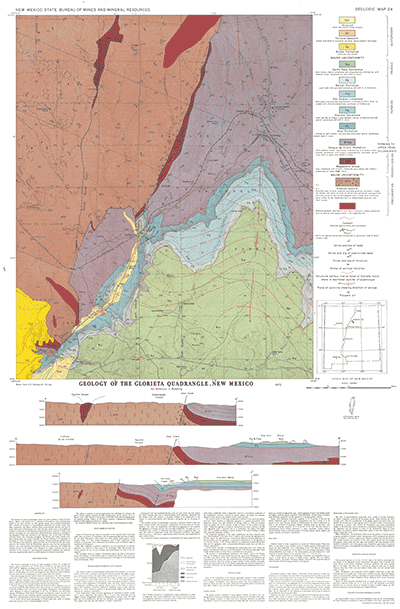
The Glorieta 7½-minute quadrangle is about ten miles southeast of Santa Fe, New Mexico. Much of the western part is underlain by Precambrian rocks, predominantly granite of two main varieties: an older gneissic granite, and a younger leucogranite. Also included are remnants of metamorphosed sediments and volcanic rocks, basic dikes, pegmatites, and aplites. Faulting along north-northeast fractures may have already taken place in Precambrian time. One, the Deer Creek Fault, is most likely the southern continuation of the Precambrian Picuris-Pecos fault traced for 53 miles to the north in the Sangre de Cristo Mountains. Marine limestones, sandstones, and shales of the Magdalena Group were deposited in late Paleozoic time. At the close of the Pennsylvanian Period, and continuing throughout the Permian and Triassic Periods, however, sedimentation was mostly terrestrial and littoral resulting in the deposition of the Sangre de Cristo Formation, Yeso Formation, Glorieta Sandstone, Bernal Formation, and Santa Rosa Sandstone. Beginning at the end of the Mesozoic Era and continuing into the Tertiary, both the Precambrian basement rocks and the overlying sedimentary strata were deformed; Precambrian faults were rejuvenated, and folding and faulting occurred in the bedded rocks. Prospects for copper, titanium, and iron are restricted to the remnants of metamorphosed Precambrian sediments and volcanics. Abundant pegmatites have failed to provide minerals of economic importance.
$5.00
Buy
Now
Also available as a free download.
Download
| File Name | Size | Last Modified |
|---|---|---|
| GM-24_map.pdf | 18.02 MB | 02/05/2021 02:58:33 PM |
| TIFF: | ||
| GM-24_map-pal.tif | 31.03 MB | 09/17/2018 04:37:13 PM |
| GM-24_map.tif | 164.86 MB | 09/17/2018 04:33:23 PM |