


GM-48 — Geology of Española Basin, New Mexico
We are a research and service division of:
By Vincent C. Kelley, 1978, scale 1:125,000.
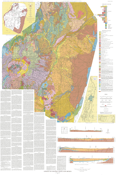
The map (fig. 1) was done as a companion to the geologic map of the Albuquerque Basin published Memoir-33 (Kelley 1977). These two maps cover most of the middle Rio Grande depression. Most of the field work was done between September 1976 and September 1977. During my career at the University of New Mexico, I worked broadly through the basin in the early fifties and mapped a number of places locally or supervised student mapping. However, the wealth of stratigraphic geomorphic and structural relationships in the basin did not become apparent until the present total field study. The early work of Kirk Bryan and his students in particular Cabot, Denny, and Smith, laid the groundwork for those of us who have come lately to study in the rift. The greatest immediate help to me has been the recent stratigraphic and paleontologic work of Galusha and Blick (1971) in which they identified two previously unrecognized formations the Chama-El Rito and Ojo Caliente, in addition to several mammalian faunal units.
To complete the present map of the basin, the geologic map by Smith, Bailey, and Ross (1970) was incorporated, with very little modification, into fig 1. Maps by Disbrow and Stoll (1957) Miller, Montgomery, and Sutherland (1963), Spiegel and Baldwin (1963), and Bingler (1968) have also been used locally with modifications. Public Service Land Company, University of New Mexico Research Allocations Committee, the Geoscience Group at Los Alamos Scientific Laboratory, and the New Mexico Bureau of Mines and Mineral Resources financially supported various parts of the work.
$8.00
Buy
Now
Also available as a free download.
Download
| File Name | Size | Last Modified |
|---|---|---|
| GM-48_map.pdf | 26.87 MB | 02/05/2021 03:33:00 PM |
| TIFF: | ||
| GM-48_map-pal.tif | 74.13 MB | 09/12/2018 09:07:12 AM |
| GM-48_map.tif | 350.31 MB | 09/12/2018 08:58:50 AM |