


GM-54 — Geology of Anthony quadrangle, Doña Ana County, New Mexico
We are a research and service division of:
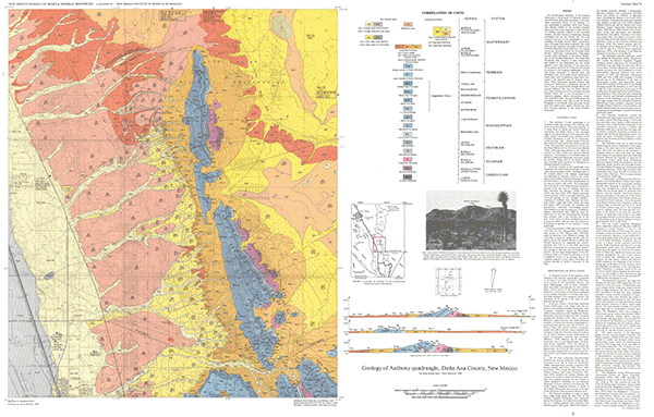
By S. Kelley and J. P. Matheny, 1983, lat 32°00' to 32°07'30", long 106°30' to 106°37'30", scale 1:24,000. A color geologic map of the Anthony 7½-min quadrangle.
The text gives explanations and lithologic descriptions of each unit mapped; a detailed stratigraphic column is included on the back of the map.
The northern-most extension of the Franklin Mountains, a titled block of Paleozoic (Ordovician–Permian) carbonates and shales, is the dominant topographic feature of the Anthony 7½-min quadrangle in southeast Doña Ana County, New Mexico. Rocks of the northern Franklin Mountains have been subjected to early Tertiary (?) folding, possibly related to the Laramide orogeny, and late Tertiary to Quaternary faulting associated with the Rio Grande rift.
The most unusual structures in the quadrangles are north-trending, low-angle, normal faults. Apparently, these low-angle fault planes originally were steep fractures that rotated to low-angle attitudes as the Franklin Mountains block tilted west. As rotation continued, movement along the low-angle faults became inefficient; consequently, high-angle, normal faults developed in the Hueco Bolson, east of the Franklin Mountains. The Camp Rice Formation (late Tertiary to early Quaternary) and middle to late Quaternary fan and eolian deposits cover large portions of the map area. Three distinct facies of the Camp Rice Formation are present in the Anthony quadrangle: 1) a fluvial facies composed of channel sand and floodplain clay, 2) an eolian facies consisting of loamy sand, and 3) a piedmont-slope facies composed of fan material from the adjacent mountains. These Quaternary deposits indicate that during the Pleistocene a substantial amount of water from the ancestral Rio Grande flowed east through Fillmore Pass into the Hueco Bolson. Less water flowing west of the mountains into the Mesilla Valley led to the development of a relatively stagnant, deltaic environment, southwest of Fillmore Pass. During the Pleistocene, the prevailing westerly wind blew across the broad floodplain in the Mesilla Valley and piled fluvial sand into eolian dunes against alluvial fans that were forming adjacent to the rising Franklin Mountains.
$6.00
Buy
Now
Also available as a free download.
Download
| File Name | Size | Last Modified |
|---|---|---|
| GM-54_Anthony.pdf | 11.28 MB | 02/05/2021 03:42:23 PM |
| GM-54_AnthonyDiscussion.pdf | 5.86 MB | 02/05/2021 03:42:15 PM |
| GM-54_AnthonyFrontAndBack.pdf | 17.74 MB | 04/28/2020 08:23:02 AM |
| GM-54_Anthony_GeoPDF.pdf | 15.06 MB | 11/15/2022 09:46:49 AM |
| GIS-data: | ||
| GM-54_Anthony.mpk | 98.16 MB | 11/15/2022 01:06:58 PM |
| TIFF: | ||
| GM-54_back.tif | 12.61 MB | 09/10/2018 04:15:43 PM |
| GM-54_map-pal.tif | 21.08 MB | 09/10/2018 04:12:49 PM |
| GM-54_map.tif | 133.03 MB | 09/10/2018 04:11:11 PM |