


Open-file Geologic Map - 263
Geologic Map of the Clark Spring Canyon 7.5-Minute Quadrangle, Sierra County, New Mexico
Andrew P. Jochems and Daniel J. Koning
2017
(last revised: 21-August-2017)
scale 1 : 24,000
https://doi.org/10.58799/OF-GM-263
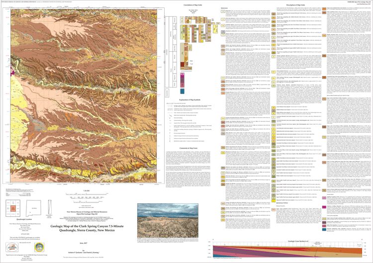
The Clark Spring Canyon 7.5-minute quadrangle is located in the southwestern part of the Palomas basin, an east-tilted half graben in the southern Rio Grande rift. The map area includes the eastern piedmont of Sibley Mountain and contains long stretches of the following east-flowing tributaries to the Rio Grande (from north to south): Trujillo Creek, Tierra Blanca Creek, and Berrenda Creek. The oldest rocks exposed in the quadrangle are andesites thought to be Oligocene (to perhaps lower Miocene) in age. Quaternary-Tertiary basin-fill deposits dominate the geology of the quadrangle. Basin-fill that is inferred to correlate to the Miocene Rincon Valley and Hayner Ranch Formations is found along the western margin of the quadrangle where the aforementioned drainages have incised canyons 65-90 m deep. Above these units lie up to 90 m of Plio-Pleistocene gravel, sand, silt, and clay belonging to the Palomas Formation. The Palomas Formation is exposed over approximately 80% of the map area. Younger deposits (middle Pleistocene to Holocene) include alluvial fans and well-defined suites of terraces in the major drainages. The youngest pre-modern deposits have been radiocarbon-dated at ~300-700 cal yr BP. The Palomas Formation and late Quaternary valley fill are most likely to host aquifers.
Downloads
| File Name | Size | Last Modified |
|---|---|---|
| OFGM-263_ClarkSpringCanyon.pdf | 17.58 MB | 02/19/2021 02:19:33 PM |
| OFGM-263_ClarkSpringCanyonReport.pdf | 3.02 MB | 02/19/2021 02:19:41 PM |
| GISdata: | ||
| OFGM-263_ClarkSpringCanyon.mpk | 29.90 MB | 08/21/2017 03:45:12 PM |
Notes:
Geologic mapping of this and other 7½-minute quadrangles in New Mexico is being cooperatively funded by the USGS through the STATEMAP program and with matching funds from the Bureau. For a list of quadrangles in this series, please visit the Open-file Geologic Map (OF-GM) page or try our search page for geologic maps of any series.
These maps are open-filed as they become available. Initially, maps are posted as PDF files of scans of the hand-drawn linework, and later as full color maps and GIS products. These files can be downloaded for free or may be purchased on CD-ROM.
These maps are subject to frequent revisions and may be unavailable when being revised. Map Reference dates show the time of initial compilation; Map Revision dates, when given, indicate the most current version of the map; Last Modified dates for files may not accurately reflect the time the map was last revised.
Please direct comments or requests regarding these maps to either the map authors or the Geologic Mapping Program Manager.