


RM-9 — Mines, Processing Plants, and Power Plants in New Mexico
We are a research and service division of:
by W. T. Siemers and G. S. Austin, 1979, 25pp, and 1 map sheet, 1:1,000,000
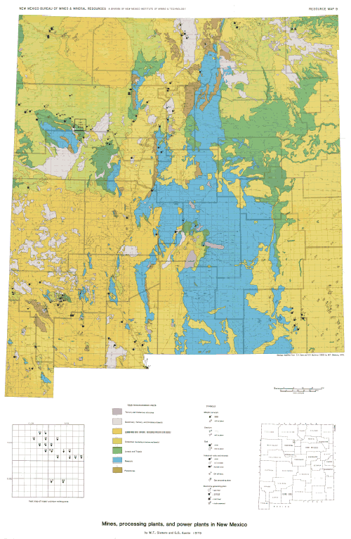
This resource map identifies and locates most of the mineral and energy operations in New Mexico-including mines, processing plants, refineries, and power plants, but excluding all sand-and-gravel operations and oil and gas wells. Mines and plants are plotted on one map to show the frequent interdependence of extraction and treatment operations-such as in Grant County. These mines a~d mills have profoundly influenced the history and economy of the state: large companies have dominated the industry, but a glance at the directories included here indicates that smaller, newer companies are also playing a key role in the development of New Mexico's mineral industry.
The mine/plant locations are superimposed on a generalized geologic map to portray the fundamental relationship between mineral resources and geologic formations, especially for teachers, students, planners, and interested citizens in New Mexico and elsewhere. Mine and plant locations are plotted on a I: I ,000,000 U. S. Geological Survey base map; the geology is modified from the standard geologic map of New Mexico (Dane, C. H., and Bachman, G. 0., 1965, Geologic map of New Mexico: U. S. Geological Survey, scale I :500,000). Resource Map 9 can be used as a wall map; therefore, the comprehensive directory is issued as an accompanying pamphlet to facilitate cross-checking of information.
$10.00
Buy
Now
This publication is out-of-print.
It is available on CD or DVD-ROM.
Also available as a free download.
Also available as a free download.
Download
| File Name | Size | Last Modified |
|---|---|---|
| RM-9.pdf | 69.61 MB | 02/16/2021 03:54:30 PM |