


Overview of Fresh and Brackish Water Quality - Mesilla Basin
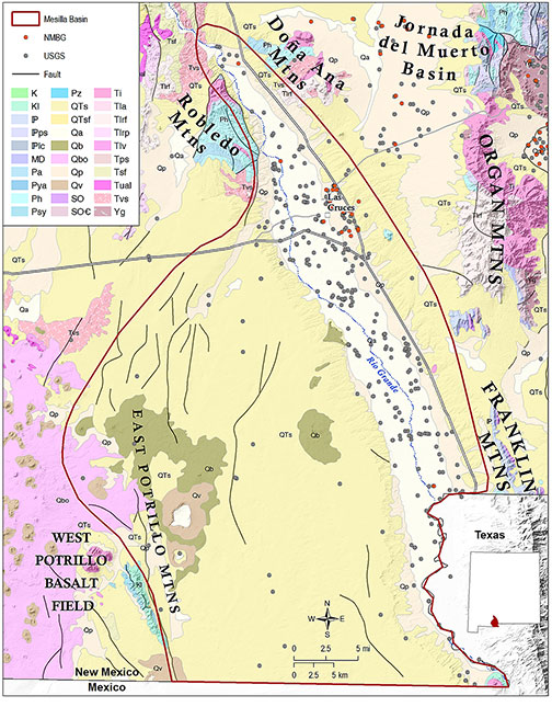
The Mesilla Basin is one of the southernmost basins of the Rio Grande Rift system, extending from south-central New Mexico across state and international boundaries into west Texas and northern Chihuahua, Mexico. The hydrology of the Mesilla Basin region has been subject to extensive investigations for over a century (e.g., Slichter, 1905; Theis, 1938; Sayre and Livingston, 1945; Conover, 1954; Leggat et al., 1962; Hawley et al., 1969; King et al., 1971; Wilson and White, 1984; Hawley and Lozinsky, 1992; Nickerson and Myers, 1993; Kennedy et al., 2000), as summarized by Hawley et al. (2001), who is paraphrased here. The eastern margin of the Mesilla Basin is defined by the Organ-Franklin-Juarez mountain chain, and the western margin by fault block and volcanic uplands of the East Potrillo Mountains and West Potrillo basalt field. The Robledo and Doña Ana Mountains define the northern end of the Mesilla Basin. The northeast end of the basin is transitional with the Jornada del Muerto Basin. The southern basin boundary with the Bolson de los Muertos in northern Chihuahua state is less well-defined. The entrenched Mesilla Valley of the Rio Grande crosses the eastern margin of the Mesilla Basin, where the cities of Las Cruces, NM, El Paso, Texas, and Juarez, Mexico exploit groundwater resources from the basin aquifers. Regional groundwater and surface water flow is to the southeast toward El Paso, through a gap separating the Franklin Mountains from Sierra Juarez to the south.
Poorly consolidated sands and gravels of the Tertiary-Quaternary Santa Fe Group form the principal basin-fill aquifer in the Mesilla Basin, and are overlain by an alluvial aquifer made up of late Quaternary channel and floodplain deposits of the Rio Grande and its tributaries. Fluvial deposits associated with the Rio Grande are ~100 feet thick and may be up to five miles wide. Both aquifers are hydrologically connected to the Rio Grande.
The Santa Fe Group basin-fill aquifer attains a maximum saturated thickness of ~3,000 feet, and has been informally subdivided into upper, middle and lower Santa Fe hydrostratigraphic units (Hawley et al. 2001). Water quality in the upper unit is similar to water chemistry of the shallow valley-fill aquifer, which is the principal source of recharge to the upper part of the basin-fill aquifer system. Water quality in the middle Santa Fe hydrostratigraphic unit is of better quality than in the overlying alluvial and basin fill units. The middle Santa Fe is also the most heavily developed aquifer zone for municipal and private drinking water. Water in the lowermost Santa Fe unit is in general of poorer quality than the overlying hydrostratigraphic zones. Spatial variability of water quality throughout the Mesilla Basin is primarily due to the irregular distribution of fine-grained confining beds within the basin fill (Hawley, 2001). There is a significant source of high chloride content geothermal water east of the Mesilla Valley that degrades the water quality in that part of the basin. Hawley et al. (2001) also report a deterioration in water quality near the basin’s southern end.
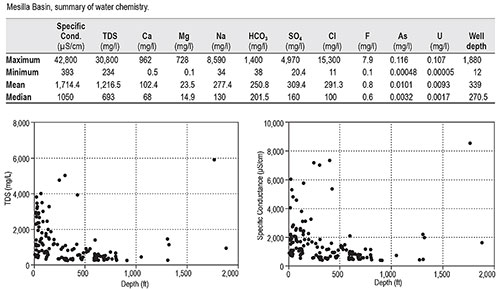
The data set for the Mesilla Basin is relatively large (408 records) but irregulary distributed, with most of the wells sampled concentrated in the Mesilla Valley from north of Las Cruces to the state line. Data distribution in the western part of the basin is very sparse. Previous workers (Hawley et al., 2001; Hawley, 2016) have suggested that significant resources of slightly brackish water are present in the Mesilla Basin. However, our records are very limited for the deeper portions of the basin, with mean well depth of only 339 feet.
Basin-wide mineral content is rather high, with mean TDS values >1,200 mg/l. However, this mean value is skewed by the presence of two samples with very high mineral content collected from different depths in the same well, located within the city limits of Las Cruces. One sample, collected from 75 feet, reported a TDS value of 19,000 mg/l. A second sample, collected from 165 feet, had a TDS content of 30,800 mg/l. This sampling bias is reflected in the median TDS value for the basin of only 693 mg/l. Our records also indicate elevated levels of arsenic, with a basin-wide mean value .01 mg/l, the maximum EPA MCL for that constituent.
This project is funded by the New Mexico Environment Department, Drinking Water Bureau, under Source Water Protection.
For more information:
see: Overview of Regional Brackish Water Assessments
or contact:
Lewis Land — Hydrogeologist, lland@nckri.org
References
- Land, Lewis, 2016, Overview of Fresh and Brackish Water Quality in New Mexico - Mesilla Basin, Project Summary Sheet.
- Land, Lewis, 2016, Overview of Fresh and Brackish Water Quality in New Mexico, New Mexico Bureau of Geology Mineral Resources, Open-file Report, v. 0583, pp. 55.