


Mount Moulton
We are a research and service division of:
The summit crater of Mt. Moulton, in West Antarctica, contains a 600-m thick horizontally-exposed section of ice with intercalated tephra layers from nearby Mount Berlin. 40Ar/39Ar dating of the thick, near-source tephra indicates that the age of the horizontal ice section ranges between 16,000 and 480,000 years. Thus, the Mount Moulton site offers an unparalleled repository of ancient West Antarctic snow and trapped air that can be used to investigate West Antarctic climate over as much as the last 500,000 years. The planar nature of the tephra layers suggests that, although the ice section is thinned, it is otherwise undeformed. The Mt. Moulton site was visited during the 1999/2000 field season, at which time approximately 400 meters of ice, ranging from 16,000 to older than 480,000 years old was collected. In addition to this horizontal core, samples of ice at a range of depths were collected in order to test the quality of the climate record in the ice. Furthermore, 40 tephra layers intercalated in the ice were collected in order to provide chronology for the ice section. Blue ice exposed on the glaciated summit of Mt. Moulton volcano, in West Antarctica (Fig. 1) contains at least 40 englacial tephra layers. These layers are exposed in an area where ice flow from the summit caldera of Mt. Moulton is banked against a rocky outcrop on the southern side of the volcano (Fig. 1).
The stratigraphy
of the tephra layers appears simple based on the detailed GPS map produced
during the 1999/2001 field season (Fig. 2). This map shows that the outcrop
pattern of individual tephra layers are straight, or slightly curved, and
that the thickness of ice between layers remains relatively constant throughout
the section. This information suggests that the blue ice section at 
The Mt. Moulton blue ice section exhibits a dramatic sequence of 48 englacial tephra layers, arranged in a simple, near-parallel geometry (Fig. 2). These range from layers with pumice clasts up to 2 cm and thicknesses of 15 cm to layers so fine and thin that they are most easily visible by the slight depression in the ice caused solar heating as consequence of the subtly lower albedo of tephra-bearing ice. The thick, coarse tephra layers typically contain highly expanded pumice and also contains obsidian fragments.
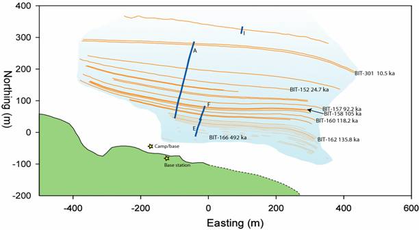
Figure 2. GPS-produced map of the Mt. Moulton tephra section. Orange lines represent tephra layers. Area shown in blue represents the extent of the exposed blue ice. Areas around the blue ice are snow-covered. The green area of the image represents rock outcrop.
This sequence contains a number of layers with trachytic pumice ranging between 2 and 3 mm in diameter. The large size of the pumice suggests that the volcano that produced these tephra layers must be located in close proximity to the catchment area that feeds the blue ice field. Pumice of this size typically may travel tens of kilometers from vent during an energetic, explosive eruption (Fisher and Schmincke, 1984). These physical constraints strongly indicate, as suggested by (Wilch et al., 1999) that nearby Mt. Berlin is the source of the coarse-grained tephra layers found in the ice at Mt. Moulton (Fig. 3).
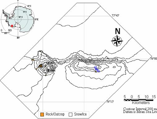
Figure 3. Map of Mt. Moulton and associated volcano, Mt. Berlin.
Mt. Berlin is still thermally active, and shows evidence of having produced recent, explosive eruption (Wilch, 1998), and is therefore an obvious source for the pumice found at Mt. Moulton. Geochemical similarities between the trachytic composition of coarse-grained tephra layers found at Mt. Moulton (Fig. 4) and erupted material sampled at Mt. Berlin further reinforce this conclusion (Wilch et al., 1999).
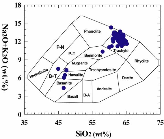
Figure 4. Total alkali-silica diagram showing average glass compositions of all analyzed Mt. Moulton tephra layers. Diagram after (Cox et al., 1979).
The fine-grained trachytic tephra layers at Mt. Moulton are also likely to be derived from Mt. Berlin. This argument cannot be made based on physical constraints, because the finer-grained tephra could have traveled much further than the coarse pumice. However, the geochemical signature of the fine-grained, as well as the coarse grained, tephra layers is consistent with derivation from Mt. Berlin, but not consistent with derivation from Mt. Takahe, the other West Antarctic volcano that could have produced explosive eruptions during this time. Specifically, the MgO content of the tephra layers found at Mt. Moulton is inconsistent with derivation from Mt. Takahe, but is consistent with know magmatic composition at Mt. Berlin ((Wilch et al., 1999). A further argument for all of the trachytic Mt. Moulton tephra layers to have been derived from a single source volcano is the trend in geochemical composition of the tephra layers as a function of time. A trend such as this one is more likely to be derived from a single volcano that is undergoing geochemical evolution as a function of time. If tephra layers derived from other volcanoes were part of the tephra sequence, their compositions would be unlikely to conform to the trends exhibited. A number of more primitive tephra layers are found in the Mt. Moulton tephra section. These are dispersed throughout the ice section, and are likely to be derived from small vents not far from Mt. Moulton because the dispersal of mafic eruptions is typically less than for explosive trachytic events. There are a number of small mafic centers on the flanks of Mt. Berlin (Wilch, 1997), and these could be the source of some of the mafic ashes. The three lowest ashes in the Mt. Moulton section are all mafic, and are all relatively coarse-grained (1 mm or greater). These tephra may be derived from a local mafic center on Mt. Moulton that has since been obscured by glaciation.
Although the geochemical composition of the Mt. Moulton trachytic tephra layers appears to be consistent throughout the sequence, the texture of the tephra varies considerably. At one end of the spectrum, the coarsely pumiceous samples are composed of highly expanded glass. Much of this pumice is expanded to the point that few selvages with diameter greater than 10 microns exist. This texture is consistent with derivation from a volatile-rich, highly explosive eruption (Houghton and Wilson, 1989). (Wilch, 1997) estimates that the eruptions that produced the coarse pumiceous deposits found at Mt. Moulton may have had eruptive columns 30 km high. The finer-grained samples are typically less pumiceous, and, although abundant bubbles are present in the samples, the ratio of glass to bubble is much higher than in the more expanded samples. The higher density of the fine deposits suggest that they were derived from less energetic eruptions with lower eruption rates (Houghton and Wilson, 1989). A third type of texture that is observed is glass containing abundant microlitic plagioclase crystals. The physical characteristics of the fragments in the fine-grained microlite-poor and microlite-rich deposits are very similar, but the quantity of microlites is dramatically higher in some deposits. The presence of microlites in a deposit can suggest that degassing occurred prior to fragmention (Gardner et al., 1998; Hammer et al., 1999; Hammer et al., 2000), presumably resulting in a less explosive eruption. Therefore, we suggest that the difference in physical characteristics of the Mt. Moulton tephra layers, both in terms of tephra layer thickness and grain size, are largely controlled by the degree of explosivity of the source eruption. An alternative factor that could be responsible for the variations in thickness and grain size of the tephra layers is wind direction at the time of eruption. Following this explanation, two eruptions of similar size could result in very different tephra deposits at a given location depending on whether the wind was blowing towards, or away, from the deposition site at the time of eruption ((Wilson and Houghton, 2000). Although the wind direction would certainly play some role in influencing the deposition of tephra layers at Mt. Moulton during eruptions of Mt. Berlin, the apparent correspondence between the grain size and physical characteristics of the deposits suggest that eruptive explosivity may have been the controlling factor. A further piece of evidence in support of the correspondence between eruptive explosivity and physical characteristics of the erupted material is that one of the coarsest tephra layers in the Siple Dome core has been correlated to one of the best developed and coarsest tephra layers identified at Mt. Moulton (BIT-152) (Dunbar et al., 2003; Taylor et al., 2005). Therefore, we would postulate that the Mt. Moulton tephra layers that are most likely to be found in future West Antarctic ice cores are those that are most pumiceous.
Geochemical evolution of Mt. Berlin
The Mt. Moulton tephra record provides an unparalleled integrated record of explosive volcanism from nearby Mt. Berlin. Previous geochemical studies of Mt. Berlin have relied on samples collected near the summit and on the flanks of the volcano (Wilch, 1997; Wilch et al., 1999). Mt. Berlin is heavily glaciated, resulting in incomplete exposure of recently rocks. Therefore, the record of volcanism sampled on Mt. Berlin is incomplete. The Mt. Moulton tephra section lacks the record of effusive volcanism, but does offer the record of many explosive eruptions over the past 500,000 years. Several consistent geochemical trends are apparent over this time period. Most apparent is a gradual increase in the FeO content of glass. Although there are significant variations in the FeO content of glass from eruption to eruption, the overall trend shows FeO decreasing from around 6.5 wt.% for the oldest recorded eruptions to almost 10 wt.% for the most recent eruptions. Trends in the MnO and TiO2 content of glass mirror that of FeO. In contrast, the SiO2 and K2O contents are slightly lower in the more recent eruptions. CaO is relatively constant over time until the most recent eruptions, when the CaO concentration increases dramatically. The gradual change in chemical composition could be related to progressive tapping of a single, large, chemically zoned magma chamber. The chemical trends are consistent with this type of process, with older eruptions tapping the more evolved top of the chamber, and progressively younger eruption tapping less and less evolved magma. However, there are several reasons that this scenario appears unreasonable. First, it would be unlikely that a large magma body would exist under a stratovolcano such as Mt. Berlin. In other stratovolcanoes, such as Mt. St. Helens, geophysical investigations suggest that eruptions are derived from very small bodies of melt that reside briefly in a small “holding chamber” at relatively shallow depth (refs). Second, even if a large magma chamber was present under Mt. Berlin, it would be unlikely to remain molten for the period of 500,000 years over which explosive eruptions took place. Third, if the eruptions were all derived from a single, stratified magma chamber, a greater degree of consistency in the eruptive style would be expected, with all eruptions generating tephra with a similar degree of vesicularity, or with vesicularity progressively decreasing through time as deeper, and less volatile-rich horizons of the magma chamber were tapped. What is instead observed is that some deposits are composed of highly vesiculated pumice, whereas others are much denser material, presumably derived from less explosive events.
Another possible explanation for the chemical trends observed in the tephra as a function of age is that each eruption represents a small batch of partial melt from a source under Mt. Berlin. The oldest eruptions would have been produced when the source was undepleted, and the first partial melts would produce the most evolved magma. As batches of partial melt were progressively removed from the source, the remaining source material would become more depleted, resulting in less evolved melt batches. The dramatic increase in CaO in the last few tephra layers could be the result of melting of a Ca-rich phase that had been stable in source for most of the melting history.
Chronology of the Mt. Moulton tephra layers
The 40Ar/39Ar analyses of tephra layers in the Mt. Moulton blue ice section have provided insight into the age of the ice. Ages are determined on sanidine or anorthoclase feldspar. The coarser tephra layers provide the most accurate and precise ages, whereas the finer tephra layers are typically contaminated with older feldspar and do not yield reliable ages. A summary of the best ages is shown in Table 1. The distribution of the tephra ages along part of the Mt. Moulton section is shown in Fig. 5, and demonstrates the thinning of the ice from the upper to the lower part of the ice section. However, in the part of the ice section that is younger than 135.6 ka, the ice/tephra package exhibits easily traceable continuity, and does not appear to be deformed beyond simple thinning. Continuity is more difficult to demonstrate below 135.6 ka. However, Figure 1 demonstrates that section of tephra and ice are traceable even in the lowest part of the section, which approaches 500 ka in age.
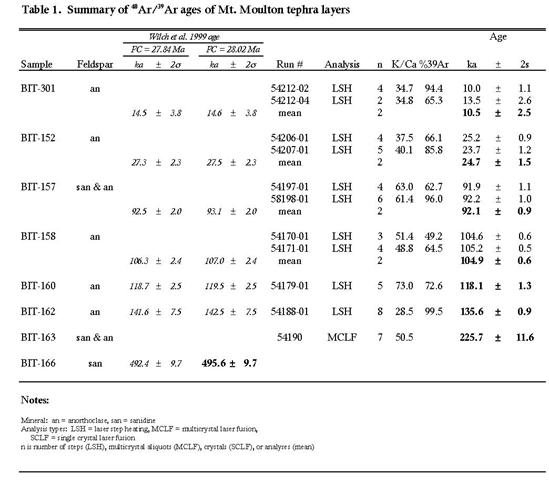
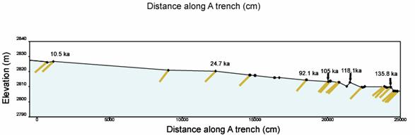
Figure 5, Schematic cross-section of the blue ice section at Mt. Moulton, showing the measured dips and ages of selected tephra layers. Topography is determined by GPS mapping
Ice dynamics and implications for an ice-based climate record
GPS measurements of a network of points, as well as measurements of ice level on bamboo poles, yielded measurable amounts of ice motion and ablation over a four year period (Fig. 6 and 7).
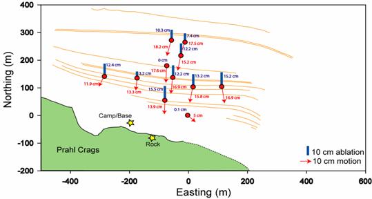
Figure 6 . Ice motion and ablation determinations for the motion network of bamboo poles. Values indicated amount of motion or ablation over a 4 year period. The ablation value is represented by the blue bars, and the magnitude and direction of motion is presented by the red arrows.
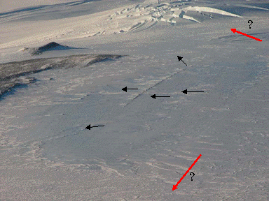
Figure 7. Field photograph of blue ice site with ice motion arrows superimposed
The measured amounts of ablation were variable, and ranged between 0 and 3.9 cm/year. The presence or absence of drifted snow may have had an impact on the amount of local ablation, and the observation that the surface of the blue ice surface is not perfectly flat, but shows waviness on a number of scales, suggests that ablation is non-uniform on a multi-year time scale. However, a number of the ablation measurements are around 2-3 cm/year, consistent with the amounts of ablation in other Antarctic blue ice area. The direction and rate of ice motion, however, which should be unaffected by local drifting, yields a more consistent picture. The surface motion of the ice in the main part of the blue ice field ranges between 3.5 and 4.5 cm/yr, and the direction of motion is directly downhill towards the local topographic obstruction, Prahl Crags. The two observation points on the east and west sides of the blue ice area both show a subordinant level of lateral motion, as well as the motion directly downhill. The observation point closest to Prahl Crags shows the least motion, and also has a higher component of lateral motion than the other observation points. This is in the area where the ice appears most thinned, and in which the tephra layers are the least continuous.
References Cited
- Cox, K.G., Bell, J.D., and Pankhurst, R.J., 1979, Interpretation of Igneous Rocks, George Allen and Unwin Press, 450 p.
- Dunbar, N.W., Kurbatov, A., Zielinski, G., McIntosh, W.C., Price, P.B., and Bay, R.C., 2003, Volcanic ash records in the Siple Dome Ice Core: West Antarctic Ice Sheet Research Meeting, September 18-19, Algonquin Regional Park.
- Fisher, R.V., and Schmincke, H.U., 1984, Pyroclastic Rocks: New York, Springer-Verlag, 472 p.
- Gardner, C.A., Cashman, K.V., and Neal, C.A., 1998, Tephra-fall deposits from the 1992 eruption of Crater Peak, Alaska: implications of clast textures for eruptive processes: Bulletin of Volcanology, v. 59, p. 537-555.
- Hammer, J.E., Cashman, K.V., Hoblitt, R.P., and Newman, S., 1999, Degassing and microlite crystallization during pre-climactic events of the 1991 eruption of Mt. Pinatubo, Philippines: Bulletin of Volcanology, v. 60, p. 355-380.
- Hammer, J.E., Cashman, K.V., and Voight, B., 2000, Magmatic processes revealed by textural and compositional trends in Merapi dome lavas: Journal of Volcanology and Geothermal Research, v. 100, p. 165-192.
- Houghton, B.F., and Wilson, C.J.N., 1989, A vesicularity index for pyroclastic deposits: Bulletin of Volcanology, v. 51, p. 451-462.
- Taylor, K.C., Alley, R.B., Meese, D.A., Spencer, M.K., Brook, E.J., Dunbar, N.W., Finkel, R., Gow, A.J., Kurbatov, A.V., Lamorey, G.W., Mayewski, P.A., Meyerson, E., Nishiizumi, K., and Zielinski, G.A., 2005, Dating the Siple Dome, Antarctica Ice Core by Manual and Computer Interpretation of Annual Layering: Journal of Glaciology, v. in press.
- Wilch, T.I., 1997, Volcanic Record of the West Antarctic Ice Sheet in Marie Byrd Land [Dissertation thesis], New Mexico Institute of Mining and Technology, Socorro.
- —, 1998, Volcanic record of the West Antarctic ice sheet in Marie Byrd
- Wilch, T.I., McIntosh, W.C., and Dunbar, N.W., 1999, Late quaternary volcanic activity in Marie Byrd Land: Potential 40Ar/39Ar dated time horizons in West Antarctic ice and marine cores: Geological Society of America Bulletin, v. 111, p. 1563-1580.
- Wilson, C.J.N., and Houghton, B.F., 2000, Pyroclast transport and deposition: San Diego, CA.