Santa Rosa Lake State Park
modified from McLemore, V.T., 1989, Santa Rosa Lake, New Mexico Geology, v. 11, no. 1, p. 8-10.
Introduction

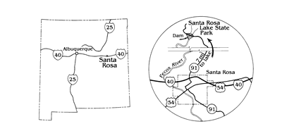
Santa Rosa, "the city of natural lakes" (Fig. 1), lies in the semiarid, upper Pecos River valley in Guadalupe County where numerous natural artesian-spring lakes abound. Blue Hole, one of these lakes located within the city limits, is well known for its crystal-clear water and attracts scuba divers. However, the largest lake in the area is man made—Santa Rosa Lake, located about seven miles north of the city on the Pecos River. The dam was completed in 1981 at a cost of $43 million for conservation of irrigation water and flood and sedimentation control (Young, 1984; Kues, 1985). The name of the dam was changed from Los Esteros (Spanish for pond or estuary) in 1980 when the state park was authorized.

U.S. Army Corps of Engineers
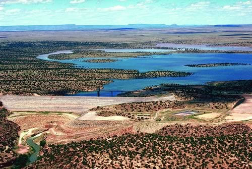
There is no permanent pool at Santa Rosa Lake (Fig. 2) because water is released periodically for irrigation use downstream. In the early 1980's the lake was considerably reduced in size, and many of the fish stocked by the New Mexico Game and Fish Department escaped downstream. The storage allocation of the lake is 200,000 acre-ft for irrigation water, 167,000 acre-ft for flood control, and 80,000 acre-ft for sedimentation control (Risser, 1987). Because of the unpredictable nature of Santa Rosa Lake, the park did not receive much attention until the last few years when the lake level has increased and stabilized. The New Mexico Game and Fish Department resumed stocking the lake, and fishermen enjoy catching bass, walleye, catfish, sunfish, crappie, and trout.
Santa Rosa Lake State Park ranges in elevation from 4,200 to 5,000 ft above sea level. Piñon pine, juniper, and yucca cover the hillslopes and mesas surrounding the lake, and various wild flowers and cacti, including cholla and prickly pear, are common. Falcons, mountain bluebirds, ducks, and geese are plentiful. A few bald eagles inhabit the area as well. Antelope and deer roam the countryside.
The U.S. Army Corps of Engineers, designers and builders of the dam, built an information center on the west side where exhibits describe the dam and various archaeological sites. The dam is 1,950 ft long and 212 ft above the streambed. It is a rock-fill structure formed in layers. The foundation of the dam was sealed by pumping concrete slurry into holes in the ground to form a grout curtain. The center of the dam consists of very fine grained, impervious material, which prohibits water seepage. The outer layer of the dam is constructed of coarse gravel including boulders as large as 48 inches in diameter (Kues, 1985). A control tower, just east of the dam within the reservoir, connects to a series of gates that regulate the water flow from the reservoir into the Pecos River. Machinery to operate the gates and a stairwell and elevator for access to the gates are located in the control tower. A road crosses over the dam. The spillway is about 1,000 ft east of the dam.
Santa Rosa Lake State Park is accessible via NM-91 from Santa Rosa. The city of Santa Rosa, the Guadalupe County seat, is located at the junction of 1-40, US-54, and US-84 (Fig. 1).
Geology

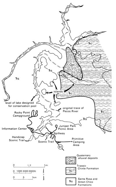
Rocks exposed in Santa Rosa Lake State Park range in age from Triassic to Quaternary (Fig. 3). The oldest unit in the park is the Triassic Anton Chico Formation. This unit was known previously as the basal sandstone of the Santa Rosa Formation, but has been redefined by Lucas and Hunt (1987). The Anton Chico Formation is as much as 80 ft thick and consists of reddish-brown and grayish-red sandstone and conglomerate that formed in stream channels. The reddish color is a result of oxidation of iron to hematite. Although fossils are rare in the Anton Chico Formation, an amphibian skull was found in the sandstone (originally reported as belonging to the Santa Rosa Formation) near Dilia in Guadalupe County (Lucas and Morales, 1985).
The Triassic Santa Rosa Formation, which is about 220 million years old, overlies the Anton Chico Formation. The unit consists of approximately 300 ft of maroon to reddishbrown to tan sandstone, siltstone, and mudstone (Fig. 3). Locally, the sandstone and siltstone are crossbedded and contain ripple marks indicating the rocks were deposited in stream channels and on floodplains as overbank deposits in alluvial and deltaic environments. Some tree branches, fossil leaves,and other plant remains were found locally in sandstones and mudstones. The Santa Rosa Formation was deposited in a semiarid continental environment, probably wetter than the present climate. Excellent exposures crop out in the dam spillway.
The Anton Chico and Santa Rosa Formations have been utilized for crushed and dimension stone. Much of the rock material used to build the dam came from these units (McDowell, 1972). Approximately 153,000 tons of asphalt or bituminous sandstone were produced from 1930 to 1939 by the New Mexico Construction Company for road-surfacing material (Gorman and Robeck, 1946). The abandoned quarries are usually inundated by the lake, but are exposed occasionally when the water level is low.
Elsewhere in the subsurface of eastern New Mexico, the Santa Rosa Formation is an oil producer (Broadhead, 1984). Heavy oil occurs in sandstone outcrops of the formation along the southeastern shore of Santa Rosa Lake (Gorman and Robeck, 1946; Budding, 1980, 1985). This oil is derived from organic material that accumulated in a reducing environment in underlying Pennsylvanian and Permian rocks and subsequently migrated into the Santa Rosa Formation (Budding, 1980, 1985).
The Triassic Chinle Formation conformably overlies the Santa Rosa Formation. This unit consists of 800 to 1,200 ft of maroon to reddish-brown mudstone, siltstone, and thin sandstone. These rocks were deposited in lacustrine and fluvial environments.
Surficial deposits of soil, gravel, silt, and clay of late Tertiary and Quaternary age cover the Triassic rocks in places. Most of these materials were deposited during the past two million years as the Pecos River cut into its present valley. Along some valleys in the area, the alluvial fill may be up to 60 ft thick.
Most of the natural lakes in the vicinity of the town of Santa Rosa are the result of solution phenomena that began during the Triassic and continue today. The town itself lies in a huge sink hole about 6 mi in diameter and 400 ft deep (Kelley, 1972b). Many of these karst depressions are nearly circular basins flanked by steep-sided cliffs of the Santa Rosa Formation (Sweeting, 1972). These features were formed by dissolution of underlying Permian limestone, gypsum, and evaporites of the San Andres Limestone and Artesia Group. Ground water dissolves these rocks, creating subsurface cavities. The overlying rocks, including the Santa Rosa Formation, collapse into the voids, creating surface depressions. The resulting fractures and faults bounding the sink holes provide conduits along which water can migrate. Water fills the surface depressions, forming lakes. In Santa Rosa Lake State Park, these circular solution features are not well developed. However, some outcrops within the park, such as part of the east wall of the spillway (Kues, 1985, fig. S6.1), are complexly faulted and deformed, probably as a result of solution phenomena.
References
- Broadhead, R. F., 1984, Subsurface petroleum geology of Santa Rosa Sandstone (Triassic), northeast New Mexico: New Mexico Bureau of Mines and Mineral Resources, Circular 193, 22 pp.
- Budding, A. J., 1980, Geology and oil characteristics of tar sand near Santa Rosa, New Mexico: New Mexico Geology, v. 2, pp. 4-5.
- Budding, A. J., 1985, Heavy-oil deposits of the Santa Rosa Formation: New Mexico Geological Society, Guidebook to the 36th Field Conference, pp. 2-3.
- Gorman, J. M., and Robeck, R. C., 1946, Geology and asphalt deposits of north-central Guadalupe County, New Mexico: U.S. Geological Survey, Oil and Gas Investigations Preliminary Map 44, 1 sheet.
- Kelley, V. C., 1972a, Geology of the Fort Sumner sheet, New Mexico: New Mexico Bureau of Mines and Mineral Resources, Bulletin 98, 55 pp.
- Kelley, V. C., 1972b, Geology of the Santa Rosa area: New Mexico Geological Society, Guidebook to the 23rd Field Conference, pp. 218-220.
- Kues, B. S., 1985, Supplemental road log 6, from Santa Rosa to Santa Rosa Lake State Park: New Mexico Geological Society, Guidebook to the 36th Field Conference, pp. 89-91.
- Lucas, S. G., and Hunt, A. P., 1987, Stratigraphy of the Anton Chico and Santa Rosa Formations, Triassic of east-central New Mexico: Journal of the Arizona-Nevada Academy of Science, v. 22, pp. 21-33.
- Lucas, S. G., and Morales, M., 1985, Middle Triassic amphibian from basal Santa Rosa Formation, east-central New Mexico: New Mexico Geological Society, Guidebook to the 36th Field Conference, pp. 56-58.
- McDowell, T. E., 1972, Geology of Los Esteros dam site: New Mexico Geological Society, Guidebook to the 23rd Field Conference, pp. 178-183.
- Pearce, T. M., 1965, New Mexico place names: University of New Mexico Press, Albuquerque, 198 pp.
- Risser, D. W., 1987, Possible changes in ground water flow to the Pecos River caused by Santa Rosa Lake, Guadalupe County, New Mexico: U.S. Geological Survey, Water Resources Investigation Report 85-4291, 15 pp.
- Sweeting, M. M., 1972, Karst and solution phenomena in the Santa Rosa area, New Mexico: New Mexico Geological Society, Guidebook to the 23rd Field Conference, pp. 168-170.
- Young, J. V., 1984, The state parks of New Mexico: University of New Mexico Press, Albuquerque, 160 pp.


