


GM-49—Coal Geology of Torreon Wash area, southeast San Juan Basin, New Mexico
We are a research and service division of:
By D. E. Tabet and S. J. Frost, 1979, lat approx. 35°30'00" to 35°55'00", long approx. 107°05'00" to 107°30'00", text, 3 sheets, scale 1:24,000.
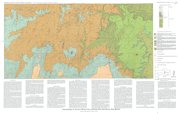
Maps showing bedrock geology and coal beds of Mesaverde Group rocks in the southeastern San Juan Basin. Text describes stratigraphy, structure, and information about coal resources, coal analyses, and coal mines and prospects.
The Torreon Wash area basically consists of a series of three north-sloping, sandstone-capped mesas, each one stepping successively up to the north. From south to north theses mesas are formed by the Point Lookout Sandstone, the sandy middle member of the Menefee Formation, and the Cliff House Sandstone. The intermittent Chico Arroyo and Torreon Wash, two main tributaries of the Rio Puerco, traverse the area from west to east and north to south respectively. The area has been deeply dissected by these two main washes and their tributaries. In the southern part of the area extensive erosion has exhumed various volcanic necks around the lava-capped Mesa Chivato. At 8,091 ft above sea level, Mesa Chivato is the highest point in the area; Chacra Mesa in the north is the second highest point, reaching 7,078 ft. The lowest point is along the Chico Arroyo in the south at 5,940 ft above sea level.
$9.00
Buy
Now
Also available as a free download.
Download
| File Name | Size | Last Modified |
|---|---|---|
| GM-49_complete.zip | 37.73 MB | 02/05/2021 03:36:53 PM |
| GM-49_discussion.pdf | 4.58 MB | 02/05/2021 03:35:32 PM |
| GM-49_map-errata.pdf | 466 KB | 02/05/2021 03:34:34 PM |
| GM-49_map-sheet1.pdf | 13.32 MB | 02/05/2021 03:34:49 PM |
| GM-49_map-sheet2.pdf | 10.58 MB | 02/05/2021 03:35:03 PM |
| GM-49_map-sheet3.pdf | 9.90 MB | 02/05/2021 03:35:16 PM |
| GM-50_discussion.pdf | 4.59 MB | 09/11/2018 04:33:03 PM |
| TIFF: | ||
| GM-49_map-errata-pal.tif | 443 KB | 09/11/2018 04:48:08 PM |
| GM-49_map-errata.tif | 2.92 MB | 09/11/2018 04:47:37 PM |
| GM-49_map-sheet1-pal.tif | 30.48 MB | 09/11/2018 03:33:01 PM |
| GM-49_map-sheet1.tif | 165.22 MB | 09/11/2018 03:31:38 PM |
| GM-49_map-sheet2-pal.tif | 27.08 MB | 09/11/2018 04:38:50 PM |
| GM-49_map-sheet2.tif | 154.45 MB | 09/11/2018 04:38:28 PM |
| GM-49_map-sheet3-pal.tif | 27.09 MB | 09/11/2018 04:42:55 PM |
| GM-49_map-sheet3.tif | 149.83 MB | 09/11/2018 04:42:32 PM |