


GM-72—Geology of El Morro quadrangle, Cibola County, New Mexico
We are a research and service division of:
By O. J. Anderson and C. H. Maxwell, 1991, lat 35°00' to 35°07'30", long 108°15' to 108°15' to 108°22'30", 1 sheet with text, scale 1:24,000.
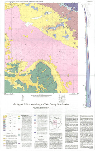
El Morro 7½-min quadrangle is located in Cibola County, 35 mi southwest of Grants along the south flank of the Zuni Mountains. Elevations range from approximately 7,135 ft in the drainage networks along the west-central and southwest boundaries of the quadrangle to 7,400 ft at Inscription Rock in El Morro National Monument, 7,790 ft on the mesa east of El Morro, and over 8,000 ft in the Zuni Mountains in the far northeast corner of the quadrangle. Lower Permian (Glorieta Sandstone) through Upper Cretaceous (Dakota Sandstone) rocks are exposed in the northeast and southwest parts of the map area, respectively. The vast North Plains basalt flows cover nearly half of the quadrangle, filling broad valleys eroded in the Chinle Formation. Pleistocene and Holocene alluvial, colluvial, and eolian deposits cover extensive areas of bedrock and basalt. Bedrock generally dips southward and southwestward away from the Zuni uplift. The Valle Largo fault, although not visible in outcrop, is indicated by contorted bedding and several minor folds and flexures. In the southwest corner of the quadrangle, the Davis anticline is offset 1.5 mi to the north by a hypothesized local shear zone. GM-72 includes historical notes on El Morro, the legendary stopping place for prehistoric Indians, Spanish, and American travelers. The authors describe a natural rockfall origin for the famous permanent water hole. GM-72 also includes one cross section and 15 map-unit descriptions.
$7.00
Buy
Now
Also available as a free download.
Download
| File Name | Size | Last Modified |
|---|---|---|
| GM-72_complete.zip | 9.27 MB | 02/05/2021 04:06:38 PM |
| GM-72_discussion.pdf | 5.68 MB | 02/05/2021 04:06:08 PM |
| GM-72_map.pdf | 3.99 MB | 02/05/2021 04:06:14 PM |
| GM-72_units.pdf | 468 KB | 02/05/2021 04:06:30 PM |
| TIFF: | ||
| GM-72_map-pal.tif | 8.17 MB | 09/14/2018 01:32:12 PM |
| GM-72_map.tif | 52.97 MB | 09/14/2018 01:31:46 PM |