


GM-73 — Geology of the White Rock quadrangle, Los Alamos and Santa Fe Counties, New Mexico
We are a research and service division of:
By D. P. Dethier, 1997, lat 35°45' to 35°52'30", long 106°07'30" to 106°15', 1 sheet (including geologic map, 11 stratigraphic sections, and text), scale 1:24,000.
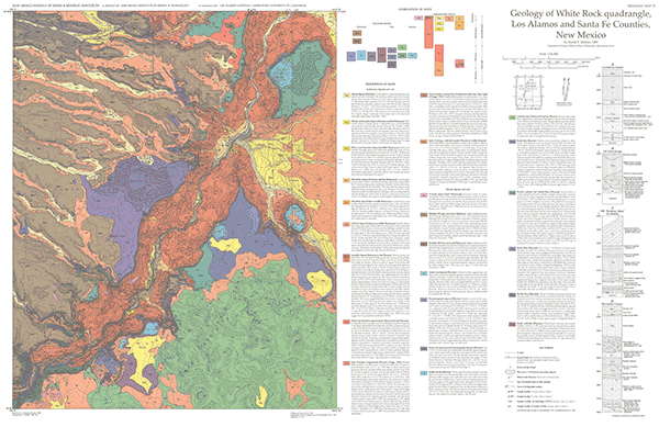
The White Rock 7½-min quadrangle in the southern Española Basin is named for the White Rock Canyon of the Rio Grande, which cuts across the map area to a depth of nearly 1,000 ft. The quadrangle encompasses the communities of White Rock and Pajarito Acres and includes parts of Bandelier National Monument, San Ildefonso Pueblo, and Santa Fe National Forest.
The White Rock quadrangle exposes a diverse suite of Miocene through Holocene rocks that record volcanism, sedimentation, and erosion along the axis of the Rio Grande rift in the southern Española Basin. Rocks were derived from volcanic sources in the Cerros del Rio and the Jemez Mountains and from eroded metamorphic and intrusive rocks exposed in the Sangre de Cristo Range. In Miocene time, before the Rio Grande developed as axial drainage for the Española Basin, the map area was on the west and southwest margin of a large alluvial-fan complex. Sometime before about 3 m.y. ago, perhaps in early Pliocene time, the Rio Grande began to run through the vicinity of White Rock Canyon. Since middle Pliocene time, the river has flowed near its present location, shifting less than 10 km laterally in response to volcanic activity along the river and to the construction of a volcaniclastic fan from the Jemez Mountains. The symmetry and age of slump complexes along the Rio Grande indicate that the river has not changed course appreciably since before middle Pleistocene time. Middle Pliocene fan construction; location, age, and chemistry of volcanic rocks erupted at maars and other vents along the Rio Grande; and the Quaternary history of White Rock Canyon are discussed. Miocene sedimentation and tectonics of the Española Basin, evolution and petrochemistry of the Cerros del Rio volcanic field, and evolution of the Jemez volcanic field have been discussed in detail by previous workers and are not examined here.
Notes: Since this map was published, further work was done on this quadrangle, and was released as OF-GM-149. Also, a portion of the southwest-corner of the map is in Sandoval County.
$7.00
Buy
Now
Also available as a free download.
Download
| File Name | Size | Last Modified |
|---|---|---|
| GM-73.pdf | 11.48 MB | 02/05/2021 04:07:01 PM |
| TIFF: | ||
| GM-73_map.tif | 11.44 MB | 09/14/2018 01:45:01 PM |