Cartography and Geographic Information Systems (GIS)

We have produced geologic and geotechnical maps since our founding in 1927 and map making remains an important part of what we do.
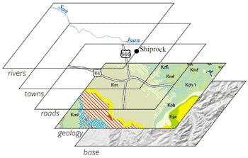
The art of making maps has changed considerably in recent years due to rapidly evolving computer technology. Geographic Information Systems (or GIS) allow digital representations of objects on a map to be connected with a database that describes that object. This ability to directly link data to objects on a map has revolutionized cartography. Geologic maps, because of their complexity, particularly benefit from being produced in a GIS format.
A large part of our effort in geologic mapping and GIS work is in producing geologic maps as part of the State Map Program. Scans of these maps are released as open-file reports prior to being digitized into GIS products and eventually GM-series maps. We are in the process of developing a new geologic data model for creating our geologic maps.
Links
- New Mexico Resource Geographic Information Program
- U.S. Geological Survey Home Page
- An ARC/INFO version of the Geologic Map of New Mexico OFR-97-0052 is available from the US Geological Survey
- New Mexico STATEMAP quadrangle index
- New Mexico Geographic Information Council, Inc.

