


RM-10 — Coal Fields and Mines of New Mexico
We are a research and service division of:
By David E. Tabet and Stephen J. Frost, 1978.
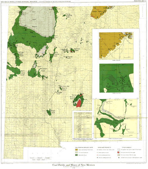
Geologic formations containing coal deposits underlie about a fifth of New Mexico. Coal resources, estimated to exceed 282 billion short tons (Shomaker and others, 1971), constitute a major asset in New Mexico's energy future. This map presents an overview of the occurrence and characteristics of coal in New Mexico. The map shows the areas where coal-bearing formations occur. The location of all active and most inactive mines are shown on the map and, in more detail, in figs. I and 2. The recognized names far the coal basins and fields are given on the map and in fig. 3. The mines shown are keyed to a list (tables 1 and 2) that gives the mine name, location, geologic coal-bearing unit, bed mined, and bed thickness. In addition, a synopsis for each field or basin (presented in alphabetical order) provides more information on the geography of the field, history of production, coal occurrence, coal rank, and coal resources. Resource figures cited include measured, indicated, and inferred tonnages combined; these figures neglect tonnages removed by mining.
$10.00
Buy
Now
This publication is out-of-print.
It is available on CD or DVD-ROM.
Also available as a free download.
Also available as a free download.
Download
| File Name | Size | Last Modified |
|---|---|---|
| RM-10.pdf | 7.12 MB | 02/16/2021 03:54:37 PM |