


RM-4 — The Chloride-Ion Concentration in Ground Water in Permian Guadalupian Rocks, Southeast New Mexico, and West Texas
We are a research and service division of:
W. L. Hiss, 1975, Scale 1:500,000.
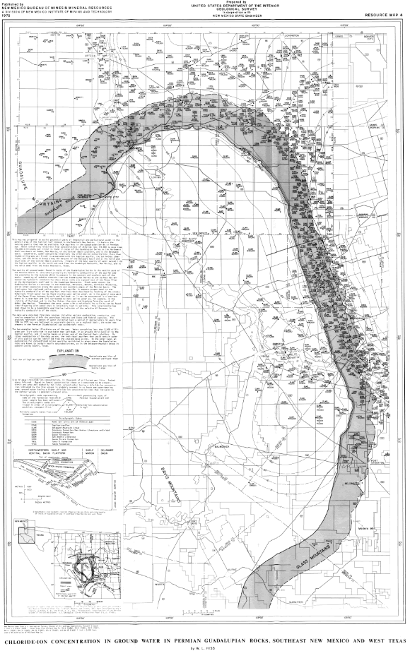
This map was prepared to assist potential users of industrial and agricultural waters in the general area of the Capitan reef located In southeastern New Mexico. It depicts the varying quality that may be available from aquifers in the Guadalupian Series of Permian age. Water containing relatively high concentrations of chloride ions (10,000 to more 150,000 milligrams per litre) Is found In rocks of the Guadalupian Series on the Northwest Shelf northwest of Hobbs, New Mexico, on the Central Basin platform, and in the Delaware basin. Conversely. water containing relatively low chloride-ion concentrations (less than 10,000 milligrams per litre) Is associated with the Capitan aquifer. the San Andres Limestone, and the Artesia Group along the margins of the Delaware basin and at the north and south ends of the Central Basin platform. fingers of the best quality of water extend into the Capitan aquifer to the north and east from the Guadalupe Mountains, New Mexico, and to the north away from the Glass Mountains, Texas.
The quality of ground water found In rocks of the Guadalupian Series in the western part of the Permian basin Is controlled primarily by hydraulic conductivity of the aquifer and the proximity to the outcrop which is present In the western and southern part of the basin. Leaching of soluble minerals from the Guadalupian Series at the surface has enhanced the hydraulic conductivity where these rocks are exposed west of the Pecos river on the Northwestern shelf and in the Guadalupe Mountains. Fresh water enters the Guadalupian Series at outcrops In the Guadalupe, Delaware, Apache, and Glass Mountains, and at other exposures along the western and southern edge of the Permian basin. The fresh water has replaced saline water in the aquifer in amounts proportional to the hydraulic conductivity of the aquifers that have been developed by leaching of the strata. Relatively fresh water may be found resting upon saline water, as in the general case west of the Pecos River between Artesia and Carlsbad, or it may be encountered in situations where it is overlain and (or) surrounded by more saline water as, for example, in the vicinity of Carlsbad and in the San Andres Limestone and Grayburg Formation south of Hobbs, New Mexico. Throughout the area, water with a relatively low salinity can be found Inter-fingering with water that is relatively high in salinity. This relationship has been shown to be a dependable qualitative indicator of the relative difference In hydraulic conductivity of the rocks.
The data were obtained from many sources including various exploration, production, and service companies within the petroleum industry and State and Federal agencies. The analyses represent samples of water collected over a period of approximately 45 years from 1926 to 1971 but are believed to accurately depict, on a regional basis, the water now present in the Permian (Guadalupian) age sedimentary rocks.
This publication is out-of-print.
Available as a free download.
Available as a free download.