


RM-8 — Vegetation and Land Use in New Mexico
We are a research and service division of:
Stanley A. Morain, Thomas K. Budge, and Mike E. White, 1977, Scale 1:1,000,000.
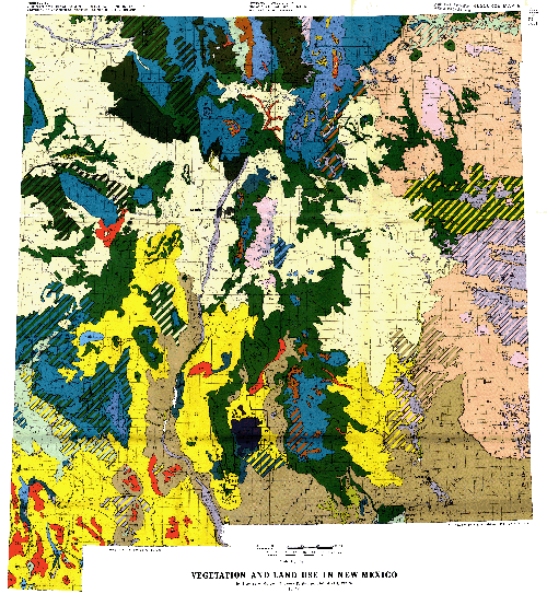
The primary purpose of this study was to map the vegetation and land use patterns of New Mexico insofar as they may be observed or inferred from small-scale satellite images. In the process, major landforms and geologic features were also mapped.
Landsat (formerly designated as "ERTS," Earth Resources Technology Satellite) imagery constitutes the mapping base. Boundaries between vegetation categories meet U.S. Geological Survey Topographic Division mapping standards for accuracy at 1: 1,000,000 scale. Transition zones between vegetation categories are less accurately mapped because of the overlapping nature of dominant species. Nevertheless, these boundary delineations are more exact than would have been possible without photographic control. Satellite imagery makes possible the acquisition of data over vast areas at one time. A comprehensive interpretation was applied to a uniform statewide base, resulting in a consistent map of the patterns of vegetation and land use in New Mexico.
Before compiling this map, all existing maps showing vegetation of New Mexico were studied. The several published maps by various Federal and State agencies were useful for their intended purposes but were not designed for broader use. In some cases, data sources were not indicated; in others, the map categories were poorly defined. In all cases the accuracy of category boundary lines was unknown because a photographic base had not been used in the mapping.
$10.00
Buy
Now
This publication is out-of-print.
It is available on CD or DVD-ROM.
Also available as a free download.
Also available as a free download.
Download
| File Name | Size | Last Modified |
|---|---|---|
| RM_8.pdf | 37.77 MB | 02/16/2021 03:54:22 PM |