


Overview of Fresh and Brackish Water Quality - San Agustin Basin
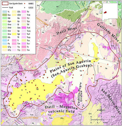
The San Agustin Basin is a closed intermontane basin on the northern edge of the Mogollon Plateau, and within the Datil-Mogollon volcanic field of southwestern New Mexico, extending across ~2,400 square miles in Catron and westernmost Socorro Counties. Myers et al. (1994) conducted an investigation of the hydrogeology of the basin, which is summarized here. The San Agustin Basin is bounded to the west and south by the Continental Divide, to the north by the Datil and Gallinas Mountains, and to the east by the San Mateo Mountains. The most recent structural activity in the region was late Tertiary Basin and Range faulting, which formed the San Agustin and Cuchillo Negro grabens. The Plains of San Agustin, which occupy the northeast-trending San Agustin graben, were covered by several large lakes during late Pleistocene time. Playas now occupy these former lake beds. There is no perennial streamflow in the basin.
The principal water-bearing unit in the San Agustin Basin is Quaternary alluvium and basin-fill material, consisting of unconsolidated clay, silt, sand and gravel derived from the surrounding volcanic uplands. Thickness of the basin fill is variable, with a maximum reported thickness of >4,000 feet. The basin fill is underlain by up to 2,000 feet of Gila Conglomerate, which is in turn underlain by Tertiary basalts and volcaniclastic rocks of the Datil Group. Both the Gila Conglomerate and rocks of the Datil Group yield small to moderate quantities of water to wells. Recharge in the basin occurs through direct precipitation and runoff from the surrounding uplands. The direction of groundwater flow varies from southwest to southeast.
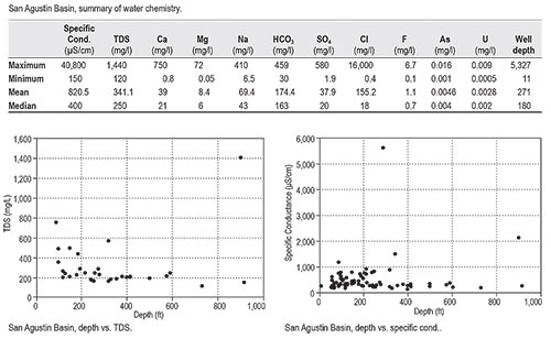
The limited data set for the San Agustin Basin (185 total well records) indicates that groundwater in the basin is generally of high quality, with a mean TDS of only 341 mg/l. Plots of TDS vs. depth show only one well that exceeds 1000 mg/l dissolved solids. Mean chloride concentration is also low (155 mg/l); however, one well is reported to have a chloride concentration of 16,000 mg/l, 64 times higher than the EPA secondary standard for chloride. That well is located in the Lake San Agustin playa in the far southwest end of the basin. Myers et al. (1994) reported large concentrations of dissolved solids, sulfate and chloride in groundwater sampled from the Lake San Agustin playa, and suggested that it may reflect either residual water from the alkaline Pleistocene Lake San Agustin, or deeply sourced water upwelling along faults. Rinehart et al. (2015) also reported evidence of warm deep brines upwelling along faults or caldera margins in the eastern San Agustin Basin.
The presence of mineralized geothermal waters in some areas suggests there may be a potential for deep brackish water resources in the San Agustin Basin. However, the mean well depth in the basin is only 271 feet, so that potential resource remains largely unexplored. The maximum well depth, 5,327 feet, is from an exploratory well drilled by Sun Oil Co. in 1966. It is interesting to note that a sample collected from that well, possibly from the Datil aquifer, had a TDS of only 174 mg/l.
This project is funded by the New Mexico Environment Department, Drinking Water Bureau, under Source Water Protection.
For more information:
see: Overview of Regional Brackish Water Assessments
or contact:
Lewis Land — Hydrogeologist, lland@nckri.org
References
- Land, Lewis, 2016, Overview of Fresh and Brackish Water Quality in New Mexico - San Agustin Basin, Project Summary Sheet.
- Land, Lewis, 2016, Overview of Fresh and Brackish Water Quality in New Mexico, New Mexico Bureau of Geology Mineral Resources, Open-file Report, v. 0583, pp. 55.