Overview of Fresh and Brackish Water Quality - High Plains Aquifer


The High Plains aquifer is one of the largest freshwater aquifers in the world, covering more than 170,000 square miles and extending across parts of eight states from South Dakota to the Texas Panhandle (Sophocleous, 2010). The first regional investigation of the High Plains was conducted by the U.S. Geological Survey at the beginning of the 20th century (Johnson, 1901). Since then, several regional studies have been conducted (e.g., Gutentag et al., 1984; Weeks et al., 1988), and a great many more localized investigations (e.g., Joeckel et al., 2014; Chaudhuri and Ale, 2014), reflecting the societal and economic importance of this very extensive aquifer system.
The main part of the High Plains aquifer is contained within the Ogallala Formation, a laterally extensive unit composed of Tertiary-age alluvial fan, lacustrine and eolian deposits derived from erosion of the Rocky Mountains (Gustavson and Winkler, 1988). The terms “Ogallala Aquifer” and “High Plains Aquifer” are often used interchangeably. However, Gutentag et al. (1984) advocated for the use of the latter term, since the Ogallala Aquifer is hydraulically connected with adjacent older and younger formations of Permian, Mesozoic and Quaternary age, and these latter units are effectively a part of the greater High Plains aquifer system.
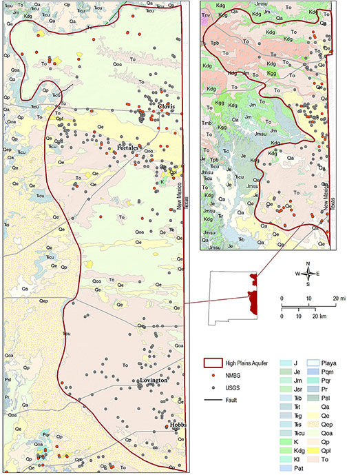
Two lobes of the High Plains aquifer extend into eastern New Mexico—a northern lobe in southern Union County, and a larger southern lobe that occupies Curry, Roosevelt, and the northern two-thirds of Lea Counties. In southern Union County, the lower Cretaceous Dakota sandstone is hydraulically connected to the overlying Ogallala Aquifer (Griggs, 1948; Kilmer, 1987). Available data indicate that the conjoined aquifers in Union County generally yield water with TDS values less than 1,000 mg/l (Rawling, 2014).
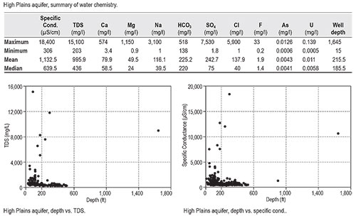
A substantial data set is available for the High Plains aquifer, with 560 records. In general, water in the New Mexico portion of the High Plains aquifer is of high quality, with a median TDS of just 436 mg/l. Very few of the wells sampled exceed 2,000 mg/l. The maximum TDS value (15,100 mg/l) is from a well located east of Portales, a short distance from the Grulla National Wildlife Refuge. The principal feature of the refuge is an ephemeral salt lake, or saline playa. Because playas are generally regarded as areas of focused recharge for the High Plains Aquifer, the well in question is probably intercepting saline water from that source, resulting in a misleadingly high mean TDS for the aquifer as a whole. The records indicate that the High Plains Aquifer is unlikely to be a reliable source of brackish water.
This project is funded by the New Mexico Environment Department, Drinking Water Bureau, under Source Water Protection.
For more information:
see: Overview of Regional Brackish Water Assessments
or contact:
Lewis Land — Hydrogeologist, lland@nckri.org
References
- Land, Lewis, 2016, Overview of Fresh and Brackish Water Quality in New Mexico - High Plains Aquifer, Project Summary Sheet.
- Land, Lewis, 2016, Overview of Fresh and Brackish Water Quality in New Mexico, New Mexico Bureau of Geology Mineral Resources, Open-file Report, v. 0583, pp. 55.


