Bosque Del Apache National Wildlife Refuge

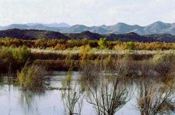
Morning sun illuminates a four-tiered landscape west of Bosque Del Apache National Wildlife Refuge, about 15 miles south of Socorro, New Mexico. On the lowest tier, salt cedar and cottonwoods in fall colors rise from Rio Grande floodplain deposits that are less than 10,000 years old (Holocene age). These alluvial deposits bury still older sediments that fill a broad channel cut by the ancestral river during the last ice age (Late Pleistocene - 15,000 to 25,000 years ago). This inner-valley fill is, in turn, inset against older river-channel and alluvial-fan deposits of middle Pleistocene to Pliocene age (0.15 to 5 million years old).
The top of the second lowest tier, above the bluffs, represents a time when the alluvial basin floor was approximately 300 feet above this camera station. The alluvial basin south of Socorro outlines the depressed half of an east-tilted fault block (half-graben) that formed during a late stage of crustal extension along the Rio Grande rift.
The uplifted halves of east-tilted blocks form the crest of the Chupadera Mountains in the middle skyline (tier three) and the Magdalena Mountains on the distant skyline (tier four). These tilted fault-block ranges and more strongly tilted fault blocks within the ranges provide evidence that the Earth's crust has been extended (stretched toward the west) about 50 percent in the last 28 million years. In other words, the 50-mile-wide north-trending zone of crustal extension near Socorro known as the central Rio Grande rift was only about 30-35 miles wide when it started to pull apart 28 million years ago.
The Magdalena and Chupadera range blocks are superimposed on giant volcanic collapse structures (calderas) that formed 29-32 million years ago, in Oligocene time. Several hundred cubic miles of red hot ash and crystals flowed out across the ancient land surface as these enormous volcanoes sank into the underlying magma chambers that were as much as 12 miles across.


