Chicosa Lake
Introduction

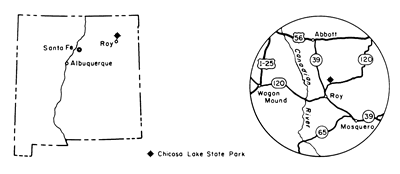
Chicosa Lake State Park closed in April 1996 because of excessive drawdown of the water table and subsequent drying of the lake; the animals were moved to Las Cruces and the land was given to the city of Roy. Chicosa Lake was an important natural waterhole on the Goodnight-Loving cattle trail . Chicosa Lake, at an elevation of 5,900 ft, is about 7 mi northeast of Roy, about 40 mi east of Wagon Mound and I-25 via NM-120 (Fig. 1).
Physiography and Geology

Chicosa Lake is an example of how geology has influenced history. This was a relatively permanent water-table lake located east of the Canadian River in the Raton section of the Great Plains physiographic province (Hawley, 1986). Without such reliable waterholes, cattle could never have made the long, dry trek to the northern markets. The lake lies within a natural basin on top of the Ogallala Formation of mid-Miocene to early Pliocene (4-12 m.y.) age. A thin veneer of younger Holocene (less than 10,000 yrs old) and upper Pleistocene (1.6 m.y. to 10,000 yrs old) sediments, derived from the underlying Ogallala Formation, covers the Ogallala at Chicosa Lake. These surficial deposits consist of 10-50 ft of gray sandy silt, clay, and organic mud reworked and deposited by water and wind (Scott, 1986). The eastern margin of the lake basin is formed by silt and clay dunes derived from the lake by wind erosion (deflation). Fossil mollusks occur in the lake sediments and are 1,000 to 27,000 yrs old (Frye et al., 1978). These small organisms are common in fresh-water permanent lakes.
The Ogallala Formation is one of the most widespread units in the United States, extending from South Dakota to southern New Mexico and northwestern Texas. It is the prime reservoir of ground water throughout the region that is responsible for man changing the appearance and character of the Great Plains. The Ogallala is approximately 200 ft thick at Chicosa Lake and consists of eolian sand and silt and fluvial sandy clay, siltstone, sandstone, and local gravel derived from the Rocky Mountains about 4-12 m.y. ago (Wanek, 1962; Reeves, 1972; Hawley, 1984; Scott, 1986). Caliche beds are common throughout the unit. Caliche is composed of fractured and permeable deposits of gravel, sand, silt, and clay cemented by calcium carbonate (McGrath and Hawley, 1987).
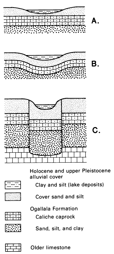
Lakes throughout the Great Plains, such as Chicosa Lake, probably formed by one, or a combination, of three methods. First, thin overlying clay, silt, and sand cover locally blows away forming dunes and leaving typically elongated, shallow deflation basins that subsequently fill with water and lake sediments (Fig. 2A; Reeves, 1971). Second, natural undulations or irregularities in the underlying caliche may also be responsible for local depressions that form shallow lakes (Fig. 2B). A third method of forming these natural depressions is by dissolution of carbonate cements in underlying rocks within the Ogallala Formation or in older limestones; a natural circular sink or collapse structure would form as the overlying materials subside or wash into resulting voids (Fig. 2C; Lucas et al., 1987; Osterkamp and Wood, 1987; Wood and Osterkamp, 1987). After the depression is formed, enlargement of the lake can occur by 1) further dissolution of underlying carbonates by downward percolation of organic acids, 2) eolian removal of clastic material from the floor of the lake, and/or 3) downward transport of clastic material by soil water (Osterkamp and Wood, 1987; Wood and Osterkamp, 1987). Eventually, the elevation of some lakes, such as Chicosa Lake, coincides with the level of the ground water in the area, thereby providing a permanent surface supply of water. The water level in the lake varies seasonally as the level of ground water changes (Frederick D. Trauger, pers. comm., 1987).
About 30 mi east of Chicosa Lake, modern technology has changed the plains. Carbon dioxide is produced from Permian sediments at depths of 1,000-2,500 ft in the Bueyeros and Bravo dome CO, fields (Broadhead, 1987). This area has reserves of 5.3 to 9.8 trillion ft3 of 98-99% CO, (Smith, 1984; Broadhead,1987). At the end of 1985, 240 wells were producing CO2 from the Bravo dome field and 18 wells were producing from the Bueyeros field. A pipeline transports the CO2 to the Permian Basin in southeastern New Mexico and west Texas where it is used to enhance oil recovery.
References
- Broadhead, R. F., 1987, Carbon dioxide in Union and Harding Counties New Mexico Geological Society, Guidebook to 38th Field Conference, pp. 339-349.
- Frye, J. C., Leonard, A. B., and Glass, H. D., 1978, Late Cenozoic sediments, molluscan faunas, and clay minerals in northeastern New Mexico: New Mexico Bureau of Mines and Mineral Resources, Circular 160, 32 pp.
- Hawley, J. W., 1984, The Ogallala Formation in eastern New Mexico; in Whetsone, G. A. (ed.), Proceedings of the Ogallala Aquifer Symposium IC Texas Tech University, Water Resources Division, pp. 157-176.
- Hawley, J. W., 1986, Physiographic provinces; in Williams, J. L. (ed.), New Mexico in maps, 2nd edition: University of New Mexico Press, Albuquerque, pp. 2327.
- Lucas, S. G., Hart, A. P., Kues, B. S., Trauger, F. D., and Holbrook, J., 1987, Second-day road log, from Clayton to Clapham, Miera, Bueyeros, Mosquero, Roy, Yates, and back to Clayton: New Mexico Geological Society, Guidebook to 38th Field Conference, pp. 23-40.
- McGrath, D. B., and Hawley, J. W., 1987, Geomorphic evolution and soil-geomorphic relationships in the Socorro area, central New Mexico; in McLemore, V. T., and Bowie, M. R. (compilers), Guidebook to the Socorro area, New Mexico: New Mexico Bureau of Mines and Mineral Resources, pp. 55-67.
- Osterkamp, W. R., and Wood, W. W., 1987, Playa-lake basins on the southern High Plains of Texas and New Mexico--Part 1, hydrologic, geomorphic, and geologic evidence for their development: Geological Society of America Bulletin, v. 99, pp. 215-223.
- Reeves, C. C., Jr., 1971, Relations of caliche to small natural depressions, southern High Plains, Texas and New Mexico: Geological Society of America Bulletin, v. 82, pp. 1983-1988.
- Reeves, C. C., Jr., 1972, Tertiary-Quaternary stratigraphy and geomorphology of west Texas and southeastern New Mexico: New Mexico Geological Society, Guidebook to the 23rd Field Conference, pp. 108-117.
- Scott, G. R., 1986, Geologic and structure contour map of the Springer 30' x 60' quadrangle, Colfax, Harding, Mora, and Union Counties, New Mexico: U.S. Geological Survey, Map 1-1705, 2 sheets, scale 1:100,000.
- Smith, L. R., 1984, "Old" area setting for new technology: Drill Bit, v. 33, no. 6, pp, 15-18.>
- Wanek, A. A., 1962, Reconnaissance geologic map of parts of Harding, San Miguel, and Mora Counties, New Mexico: U.S. Geological Survey, Oil and Gas Investigations Map OM-208, scale 1:96,000.
- Wood, W. W., and Osterkamp, W. R., 1987, Playa-lake basins in the southern High Plains of Texas and New Mexico-Part II, a hydrologic model and mass-balance arguments for their development: Geological Society of America Bulletin, v. 99, pp. 224-230.


