


Leasburg Dam State Park and Fort Selden State Monument
We are a research and service division of:
modified from McLemore, V.T., 1999, Leasburg State Park and Fort Selden State Monument: New Mexico Geology, v. 21, p. 66-70.
Introduction
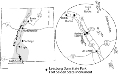
Leasburg Dam State Park is adjacent to Fort Selden State Monument on NM–157 (Fort Selden Road) at the Radium Springs exit on I–25, north of Las Cruces (Fig. 1). It is an area rich in both geologic and human history. The location was an ancient Indian campground and a crossing point for Spanish caravans headed across the Jornada del Muerto. Living-history demonstrations of 19th century military life at Fort Selden highlight many weekends during the summer. Wildlife viewing, especially bird watching, is popular at the state park. A bird list is available from the park office. In the winter months many species of ducks, teals, snow geese, cranes, herons, egrets, swans, and pelicans migrate through the southern Rio Grande valley and can be seen at the state park. Numerous raptors, including owls, turkey vultures, eagles, and hawks, can be seen hunting in the area. Small mammals common to the park include rabbits, squirrels, chipmunks, rodents, coyotes, and foxes.
Geology
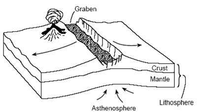
Leasburg Dam State Park and Fort Selden lie within the Rio Grande rift, which covers an area of approximately 6,500 mi2 in central New Mexico. A rift is a long, narrow feature where the Earth’s crust is being pulled apart by plate tectonic forces (Fig. 2). As the crust is pulled apart, large blocks in the center of the rift subside, thereby creating an elongate depression known as a graben. The Rio Grande rift is actually a series of linked grabens extending for approximately 600 miles from near Alamosa, Colorado, southward beyond El Paso, Texas. We know that some grabens along the Rio Grande rift have subsided as much as 20,000 ft. The Rio Grande flows south along this rift valley. Unlike most rivers that form valleys by cutting into the rocks, the Rio Grande has attempted to fill up this great depression with only short periods of actual cutting into the valley-fill deposits. Basin and Range faulting began about 30 million years ago in New Mexico and resulted in the uplift of the mountains on both sides of the Leasburg–Fort Selden area: the San Andres, Organ, Doña Ana, and Franklin Mountains to the east and the Robledo Mountains to the west (Figs. 1 and 3).
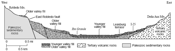
The basin fill in the downfaulted rift valley, in which Leasburg and Fort Selden are located, is comprised of interbedded gravel, sand, silt, and clay, forming the middle Miocene to middle Pleistocene Santa Fe Group, which is about 15–1 million years old in this area. The sedimentary rock sequence exposed in the Robledo Mountains and other uplifts in the area are buried in younger sedimentary rocks. The state park and fort are built mostly on a late Pleistocene terrace known as the Leasburg terrace or surface, which formed about 15,000 yrs ago. The terrace deposits were laid down long after an ancestral Rio Grande cut into the underlying Palm Park Formation and upper Santa Fe Group basin-fill deposits (Seager, 1975). The clay needed to make adobe bricks for Fort Selden came from the terrace deposits. The foundation of the dam rests on top of a rhyolite intrusion, which is exposed on the west side of the dam (Bieberman, 1979). Wind blown sand forms local sand dunes that cover the surrounding terrace deposit. The Robledo Mountains, on the west side of the river south of Leasburg Dam and Fort Selden, rise to an altitude of 5,890 ft above sea level, nearly 2,000 ft above the Rio Grande.
The mountains are part of an uplifted wedge-shaped fault block that consists of Paleozoic and Eocene sedimentary rocks (Kottlowski and Seager, 1998). The oldest rocks exposed in the Robledo Mountains are limestones of the Early Ordovician El Paso Formation, which were deposited in a shallow sea about 570 million yrs ago (Mack et al., 1998). Erosion occurred when the seas withdrew for a short time. Then the seas returned to deposit the Middle to Late Ordovician Montoya Formation, which unconformably overlies the El Paso Formation. The Montoya Formation consists of the basal Cable Canyon Sandstone, Upham Dolomite, Aleman Dolomite, and Cutter Dolomite. The Cable Canyon Sandstone is a basal sandy facies of the Upham Dolomite; the two overlying dolomites were deposited in deeper marine environments. The Early to Middle Silurian Fusselman Dolomite, which unconformably overlies the Montoya Formation, forms prominent dark double cliffs on the mountain slopes. The Fusselman Dolomite was deposited in a marine environment about 438–408 million yrs ago and forms a resistant, brownish-gray ledge of finely crystalline dolomite with abundant chert layers and nodules. The dark-gray, fissile, micaceous Devonian Percha Shale was deposited in lagoons or shallow, stagnant basins and forms slopes above the Fusselman Dolomite. The shallow seas returned to deposit the Early Mississippian Lake Valley Formation that gradationally overlies the Percha Shale and consists of calcareous shale, siltstone, and limestone. Pennsylvanian strata, also deposited in shallow-marine environments, overlie the Mississippian rocks. The Robledo Mountains are capped by the interlayered Permian Hueco–Abo Formation, representing rocks that were deposited in marine and nonmarine environments. The southernmost outcrops of the Abo Formation and the northernmost outcrops of the Hueco Formation are found interbedded in the Robledo Mountains (Kottlowski and Seager, 1998). Permian trackways that include hundreds of trails and tracks of invertebrate and vertebrate animals are preserved in the Abo Formation in the Robledo Mountains. The trackways are in ripple-laminated silty sandstone, originally tidal flats that were subjected to frequent subaerial exposure, as indicated by plant debris and raindrop imprints (Lucas, 1993).
The seas retreated, and the Eocene Love Ranch Formation fanglomerates and Eocene–Oligocene Palm Park Formation were deposited unconformably on the Hueco–Abo Formation about 57.8–36.6 million years ago. A rhyolite sill intruded the sedimentary rocks about 35.2 million yrs ago and forms Lookout Peak, the northernmost peak of the range. The broad central plain of the Jornada del Muerto extends nearly 100 miles to the north, from Radium Springs to north of Carthage in eastern Socorro County. It is one of the many grabens or basins that make up the Rio Grande rift. The Jornada del Muerto lies above the Rio Grande and contains many aligned depressions. It consists of Tertiary and Quaternary reddish clay, gypsum, interbedded breccia tuffs, latitic tuffs, latite-andesite breccias and flows, welded rhyolite tuffs, Pleistocene lake beds, and Recent fluvial gravels and sands in terraces and floodplain deposits. A short lived divergent stream of the Rio Grande flowed down the Jornada del Muerto at least as far as Engle and presumably continued south to near Rincon, 15 mi north–northwest of the state park. The Rio Grande flowed from Rincon to the south edge of Point of Rocks, an important landmark on the Jornada del Muerto northeast of the state park, then turned south toward the Doña Ana Mountains. At one time the river flowed east of the Doña Ana Mountains before shifting to its present position. The Jornada del Muerto is now a closed basin with no through drainage. The Doña Ana Mountains form the low hills east of the state park. Rocks in the Doña Ana Mountains range in age from Pennsylvanian through Recent (Seager et al., 1976). Sedimentary rocks are the oldest rocks and range in age from Pennsylvanian through Eocene. An Eocene andesite and an Oligocene monzonite have intruded the sedimentary rocks. The eruption of the 2,500-ft thick Doña Ana Rhyolite (ash-flow tuff) initiated caldera collapse about 33–34 million yrs ago (Fig. 4). The Doña Ana caldera is approximately 7–8 mi in diameter and was filled by rhyolite flows, ash-flow tuffs, domes, and breccias. Rhyolite and monzonite dikes intruded the older rocks. Late Tertiary uplift and westward tilting have elevated the mountain range to an altitude of 5,829 ft (Seager et al., 1976). A small amount of copper, gold, and silver were produced from vein deposits during the early 1900s (McLemore, 1998).
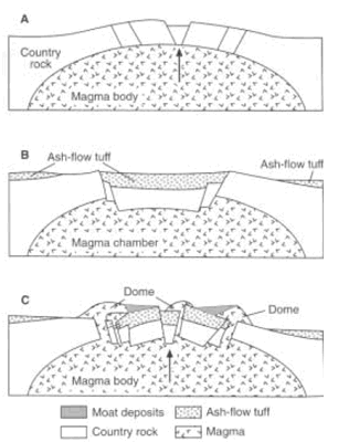
The jagged crest of the Organ Mountains can be seen on the skyline above the Doña Ana Mountains. The Organ Mountains are formed by a west-tilted block that exposed rocks ranging in age from Proterozoic through Quaternary. The oldest Proterozoic granitic rocks are overlain by as much as 8,500 ft of Paleozoic and Cretaceous sedimentary rocks, mostly of marine origin (Seager, 1981). About 35 million yrs ago, the Organ batholith and volcanic rocks associated with the Organ caldera were emplaced (Seager, 1981, Fig. 4). The Organ batholith is a large complex pluton made up of multiple intrusions and dikes. The Organ batholith formed the core of the Organ caldera, which erupted as pyroclastic flows and lavas that are exposed in the southern part of the Organ Mountains. Uplift and erosion produced younger sedimentary deposits and the rugged topography characteristic of the Organ Mountains. The Organ Mountains mining district was discovered in the 1830s and yielded an estimated $2.7 million worth of copper, lead, zinc, silver, and gold from carbonate-hosted replacement deposits and vein deposits in Proterozoic rocks. Locally iron, manganese, molybdenum, tin, tellurium, and tungsten are also reported (McLemore, 1998).
The Rio Grande rift is still active today. Low intensity earthquakes are common in this region (Seager and Morgan, 1978). The actual location of many of these earthquakes can not be determined. However, most of the activity is related to continued movement along the East Robledo fault that separates the Robledo Mountains from the valley deposits. The warm mineral waters at Radium Springs are further proof of an active rift. Hot water around 70°C is pumped from wells that are less then 225 ft deep to heat a 5.7-hectare greenhouse. The springs are part of a shallow geothermal system that is contained in a highly fractured rhyolite that intruded the Eocene Palm Park Formation (Ross and Witcher, 1998). Two drill holes indicate a deeper geothermal system at temperatures >100°C exists in fractured Paleozoic limestone and Proterozoic granite beneath the shallow rhyolite reservoir at depths <3,300 ft (Ross and Witcher, 1998).
References
- Bieberman, R. A., 1979, Ft. Selden and Leasburg: New Mexico Geology, v. 1, pp. 41–42.
- Elston, W. E., 1978, Mid-Tertiary cauldrons and their relationship to mineral resources, southwestern New Mexico: A brief review; in Chapin, C. E., and Elston, W. E. (eds.), Field guide to selected cauldrons and mining districts of the Datil–Mogollon volcanic field, New Mexico: New Mexico Geological Society, Special Publication 7, pp. 107–113.
- Hawley, J. W., and Seager, W. R., 1978, New Mexico–Texas State line to Elephant Butte Reservoir; in Hawley, J. W. (comp.), Guidebook to Rio Grande rift in New Mexico and Colorado: New Mexico Bureau of Mines and Mineral Resources, Circular 163, pp. 71–91.
- Kottlowski, F. E., and Seager, W. R., 1998, Robledo Mountains, key outcrops in south-central New Mexico; in Mack, G. H., Austin, G. S., and Barker, J. M.(eds.), Las Cruces country II: New Mexico Geological Society, Guidebook 49, pp. 3–4.
- Lucas, S. G., 1993, Geological context of Permian tracksite, Robledo Mountains, Doña Ana County, New Mexico (abs.): New Mexico Geology, v. 15, p. 103.
- Mack, G. H., Kottlowski, F. E., and Seager, W. R., 1998, The stratigraphy of south central New Mexico; in Mack, G. H., Austin, G. S., and Barker, J. M. (eds.), Las Cruces country II: New Mexico Geological Society, Guidebook 49, pp. 135–154.
- McLemore, V. T., 1998, A summary of the mineral resources in Doña Ana County, New Mexico; in Mack, G. H., Austin, G. S., and Barker, J. M. (eds.), Las Cruces country II: New Mexico Geological Society, Guidebook 49, pp. 299–307.
- Ross, H. P., and Witcher, J. C., 1998, Self-potential surveys of three geothermal areas in the southern Rio Grande rift, New Mexico; in Mack, G. H., Austin, G.S., and Barker, J. M. (eds.), Las Cruces country II: New Mexico Geological Society, Guidebook 49, pp. 93–100.
- Seager, W. R., 1975, Cenozoic tectonic evolution of the Las Cruces area, New Mexico; in Seager, W. R, Clemons, R. E., and Callender, J. F. (eds.), Las Cruces country: New Mexico Geological Society, Guidebook 26, pp. 241–250.
- Seager, W. R., 1981, Geology of Organ Mountains and southern San Andres Mountains, New Mexico; New Mexico Bureau of Mines and Mineral Resources, Memoir 36, 97 pp.
- Seager, W. R., Kottlowski, F. E., and Hawley, J. W., 1976, Geology of Doña Ana Mountains, New Mexico: New Mexico Bureau of Mines and Mineral Resources, Circular 147, 36 pp.
- Seager, W. R., and Morgan, P., 1978, Leasburg Dam–Radium Springs overlook; in Hawley, J. W. (comp.), Guidebook to Rio Grande rift in New Mexico and Colorado: New Mexico Bureau of Mines and Mineral Resources, Circular 163, pp. 75–78.
- Young, J. V., 1984, The state parks of New Mexico: University of New Mexico Press, Albuquerque, 160 pp.