


Manzano Mountains State Park
We are a research and service division of:
modified from McLemore, V.T., 2000, Manzano Mountains State Park and Abo and Quarai units of the Salinas Pueblo Missions National Monument, New Mexico Geology, v. 22, p. 108-112.
Introduction
Manzano Mountains State Park (Fig. 1), established in 1973, is located eighteen miles northwest of the town of Mountainair and is south of the village of Manzano in the foothills of the Manzano Mountains. “Manzano” is Spanish for apple and refers to old apple orchards found in the town of Manzano. The apple trees were planted after 1800 as determined by tree ring growth, although local legends claim that the apple trees were planted in the 17th century by Spanish missionaries traveling to the nearby Indian pueblos (Stanley, 1962; Julyan, 1996; Laine and Laine, 1998). The few remaining trees are probably the oldest apple trees in the United States. There are no apple trees at Manzano Mountains State Park, but Gambel oak, Emory oak, piñon, ponderosa pine, and alligator juniper trees are abundant. The alligator juniper is named for the checkered pattern on the bark of older trees, which resembles an alligator's hide. Nearby, Tajique, Torreon, and 4th of July Canyons in the Manzano Mountains contain some of the largest stands of Rocky Mountain and big-toothed maple trees in the Southwest; spectacular fall colors attract visitors from throughout the area. The Manzano Mountains also play an important role as a raptor flyway during spring and fall migrations. Some species of birds may fly 200 miles in a day and several thousand miles in a season. The park has a field checklist available to visitors who enjoy bird watching.

The 160-acre state park, at an elevation of 7,300 ft, is reached via a well-graded gravel road off NM–55 near Manzano. This same road continues on to Red Canyon and the Manzano Mountains Wilderness area, established in 1978. The 36,970-acre Manzano Mountains Wilderness ranges from juniper woodland at approximately 5,000 ft to pine and aspen at approximately 10,000 ft. It is administered by the Cibola National Forest. A 1/2-mi nature trail wanders through the park grounds; other park trails connect to trails in the Cibola National Forest via a gate at the forest boundary. One of the forest trails reaches the crest of the Manzano Mountains at an elevation of 10,098 ft. The Manzano Mountains lie in the background to the west, and the Estancia Basin lies to the east.

The main Visitor Center for the Salinas Pueblo Missions National Monument is headquartered in Mountainair. The monument, established in 1980, consists of three pueblo sites and Spanish missions: Abò, Quarai (Fig. 2), and Gran Quivira. The Quarai site, also on NM–55, is a few miles southeast of the Manzano Mountains State Park, south of Punta de Aqua. “Salinas” is Spanish for salt or salt marshes. There are no camping facilities at the national monument. In 1995, the Salt Missions Trail was established and forms a loop connecting Tijeras, Manzano Mountains State Park, Quarai, Mountainair, Gran Quivira, Willard, Estancia, and Moriarty (Fig. 2).
Geology
The Manzano Mountains are a north-south elongate, east-tilted fault block that formed as part of the eastern flank of the Rio Grande rift during Miocene time, about 20–15 m.y. ago. The oldest rocks exposed in the highest peaks of the Manzano Mountains are Proterozoic quartzites, mica schists, metasiltstones, phyllites, metarhyolite, amphibolite, and basic schist (Fig. 3; Bauer, 1982, 1983; Cavin et al., 1982). These rocks were subsequently metamorphosed (Marcoline et al., 2000) and then intruded locally by granitic rocks of the Ojita, Monte Largo, and Priest plutons. The Ojita pluton is 1,527 m.y. old, the Monte Largo pluton is 1,656 m.y. old and the Priest pluton is 1,427 m.y. old (Bauer et al., 1993). The metamorphic rocks are clearly older than the 1,656 m.y.-old Monte Largo pluton and may be as old as 1,700 m.y. (Bolton, 1976; Bowring et al., 1983). Boulders of these metamorphic rocks are scattered throughout the state park.
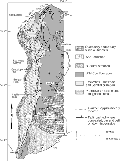
Regional uplift occurred, and erosion of several thousand feet of rock followed, forming a regional erosional surface that records no deposition in the Manzano Mountains until Late Mississippian, a gap in the geologic record of about 1.1 billion years. The contact between the substantially older Proterozoic rocks and younger Mississippian rocks is called an “unconformity.” This particular unconformity was recognized in the Grand Canyon area and was called the Great Unconformity by John Wesley Powell.
Marine seas began to cover New Mexico during late Paleozoic time and deposited Mississippian- and Pennsylvanian-age sediment unconformably on the Proterozoic rocks (Myers, 1982). The Mississipian Caloso Formation of Myers (1982) and the Pennsylvanian Sandia Formation represent the first stage of marine deposition. These units consist of a mixture of thin nonmarine limestones, siltstones, sandstones, and conglomerates and marine limestones and shales (Myers, 1982). The Caloso Formation is poorly exposed, consists of local, thin (less than 22 ft thick), nonfossiliferous limestones, and is probably part of the Arroyo Peñasco Group (Broadhead, 1997). The Sandia Formation is approximately 90–320 ft thick, and most of the sediment was probably derived from the Pedernal uplift, an Ancestral Rocky Mountain highland that was located on the site of the modern-day Pedernal Hills to the east (Fig. 2). These rocks were probably deposited about 320 m.y. ago, based on fossil evidence (Myers, 1982), and are exposed along the western foothills of the Manzano Mountains (Fig. 3).
The Madera Group overlies the Sandia Formation and represents the major marine sequence of the Pennsylvanian and Early Permian. The Madera Group is 1,200–1,270 ft thick and consists of the Los Moyos Limestone (oldest), Wild Cow Formation, and Bursum Formation (Broadhead, 1997). Many of the limestone boulders found in the state park belong to these formations. The Los Moyos Limestone and Wild Cow Formation consist of marine limestones with interbedded siltstones, shales, sandstones, and conglomerates. The Bursum Formation is the last phase (Early Permian) of marine deposition during the Pennsylvanian–Permian and consists of alternating sequences of red arkosic sandstones, red and green shales and siltstones, and greenish-gray marine limestones. Carbon dioxide (CO2) was discovered in the Pennsylvanian rocks near Estancia in 1925 (McLemore, 1984). Carbon dioxide was produced from 1932 to 1942 and was converted into dry ice.
The brick red sandstones, shales, and mudstones of the Permian Abo Formation were deposited on top of the Madera Group after the Pennsylvanian seas retreated about 250 m.y. ago. The lower units of the Abo Formation were deposited in high-energy alluvial-fan and pediment environments, and the upper units were deposited in low-energy fluvial floodplain and shallow-water lake environments (Hatchell et al., 1982). Abo sandstones were used at Abò and Quarai by the Pueblo Indians to build their homes and later the churches. The area of the state park has been stripped of younger rocks by erosion and is underlain by the Abo Formation (Fig. 3). Rocks eroding from the Manzano Mountains form a thin veneer on top of the Abo and other Permian and Pennsylvanian rocks in the surrounding Manzano area. The younger Yeso Formation, at one time overlying the Abo Formation, also has been eroded in the Manzano area and is only exposed to the east in the Estancia Basin
The state park lies on the western edge of a closed basin, called the Estancia Basin, which initially formed as a depositional basin during the Early Pennsylvanian with the deposition of the Sandia Formation and Madera Group. The present structural basin formed when the Sandia, Manzano, Manzanita, and Los Pinos Mountains were uplifted during formation of the Rio Grande rift about 20–15 m.y. ago (McLemore, 1999; Bauer et al., 2003). The Sandia, Manzano, Manzanita, and Los Pinos Mountains form the western boundary, the Pedernal Hills form the eastern boundary, Chupadera Mesa forms the southern boundary, and Lobo Hill separates the Estancia Basin from the Española Basin to the north (Broadhead, 1997).

During the last ice age between 24,000 and 12,000 yrs B.P., a large pluvial lake filled the basin (Fig. 4; Bachhuber, 1982; Smith and Anderson, 1982; Allen and Anderson, 2000). The maximum extent of the lake was approximately 40 miles long by 23 miles wide, and it would have covered the towns of Estancia and Willard with nearly 100 ft of water (Allen, 1994). Shore features, cliffs, terraces, beach ridges, and other lake features, preserved in the Estancia Basin east of the state park, record a series of changing water levels in the lake from 24,000 to 12,000 yrs B.P. caused by rapid shifts in climate. Lake Estancia gradually dried up after about 12,000 yrs B.P., and the floor became exposed (Allen and Anderson, 1993, 2000). A return to wetter conditions resulted in the filling of the basin again by a younger lake (called Lake Willard by some geologists) at about 10,000 yrs B.P. (Bachhuber, 1982; Allen and Anderson, 2000). These lakes did not have outlets to the Rio Grande or anywhere else, and the water became saline over time, in part as a result of evaporation and also as a result of contributions from underlying Yeso evaporites.
Today, a complex of playa lakes and surrounding gypsum and clay dunes remain following excavation or deflation of the ancient lake bottom since about 8,000 yrs B.P. by southwesterly wind. An overall rise in the water table and return to a slightly wetter climate have reversed the trend from deflation to sediment filling of the lakes (Allen, 1994). As saline water in some of the playas evaporated, a residue of halite (salt) and minor sodium sulfates and magnesium sulfates precipitated. The deposits of halite became valuable commodities to the Pueblo Indians that settled at Abò, Quarai, and Gran Quivira and later to the Spanish and Anglo settlers. Today, the playa lakes in Estancia Basin range in size from a few acres to more than 12 mi long (Fig. 2; Meinzer, 1911; Talmage and Wootton, 1937).
References
- Allen, B. D., 1994, Ancient lakes: a tool for understanding climatic change: Lite Geology, Summer, 3 pp.
- Allen, B. D., and Anderson, R. Y., 1993, Evidence from western North America for rapid shifts in climate during the last glacial maximum: Science, v. 260, pp. 1920–1923.
- Allen, B. D., and Anderson, R. Y., 2000, A continuous, high-resolution record of late Pleistocene climate variability from the Estancia Basin, New Mexico: Geological Society of America, Bulletin, v. 112, pp. 1444–1458.
- Bachhuber, F. W., 1982, Quaternary history of the Estancia Valley, central New Mexico; in Grambling, J. A., Wells, S. G., and Callender, J. F. (eds.), Albuquerque country II: New Mexico Geological Society, Guidebook 33, pp. 343–346.
- Bauer, P. W., 1982, Precambrian geology and tectonics of the southern Manzano Mountains, central New Mexico; in Grambling, J. A., Wells, S. G., and Callender, J. F. (eds.), Albuquerque country II: New Mexico Geological Society, Guidebook 33, pp. 211–216.
- Bauer, P. W., 1983, Geology of the Precambrian rocks of the southern Manzano Mountains, New Mexico: Unpublished MS thesis, University of New Mexico, Albuquerque, 133 pp.
- Bauer, P. W., Karlstrom, K. E., Bowring, S. A., Smith, A. G., and Goodwin, L. B., 1993, Proterozoic plutonism and regional deformation—new constraints from the southern Manzano Mountains, central New Mexico: New Mexico Geology, v. 15, pp. 49–55, 77.
- Bauer, P. W., Lozinsky, R. P., Condie, C. J., and Price, L.G., 2003, Albuquerque: a guide to its geology and culture: New Mexico Bureau of Geology and Mineral Resources, Scenic Trip 18, 181 pp.
- Bolton, W. R., 1976, Precambrian geochronology of the Sevillita Metarhyolite and the Los Pinos, Sepultura, and Priest plutons of the southern Sandia uplift, central New Mexico: Unpublished PhD dissertation, New Mexico Institute of Mining and Technology, Socorro, 57 pp.
- Bowring, S. A., Kent, S. C., and Sumner, W., 1983, Geology and U-Pb geochronology of Proterozoic rocks in the vicinity of Socorro, New Mexico; in Chapin, C. E., and Callender, J. F. (eds.), Socorro country II: New Mexico Geological Society, Guidebook 34, pp. 137–142.
- Broadhead, R. F., 1997, Subsurface geology and oil and gas potential of Estancia Basin, New Mexico: New Mexico Bureau of Mines and Mineral Resources, Bulletin 157, 54 pp.
- Cavin, W. J., Connolly, J. R., Woodward, L. A., Edwards, D. L., and Parchman, M., 1982, Precambrian stratigraphy of Manzanita and north Manzano Mountains, New Mexico; in Grambling, J. A., Wells, S. G., and Callender, J. F. (eds.), Albuquerque country II: New Mexico Geological Society, Guidebook 33, pp. 191–196.
- Hatchell, W. O., Blagbrough, J. W., and Hill, J. M., 1982, Stratigraphy and copper deposits of the Abo Formation, Abo Canyon area, central New Mexico; in Grambling, J. A., Wells, S. G., and Callender, J. F. (eds.), Albuquerque country II: New Mexico Geological Society, Guidebook 33, pp. 249–260.
- Julyan, R., 1996, The place names of New Mexico: University of New Mexico Press, Albuquerque, 385 pp.
- Laine, D., and Laine, B., 1998, New Mexico and Arizona state parks; a complete recreation guide: The Mountaineers, Seattle, 270 pp.
- Lang, R. W., 1993, Early prehistory in the Estancia Basin; in Noble, D. G. (ed.), Salinas: Ancient City Press, Santa Fe, pp. 3–5.
- Lyons, T. R., and Ebert, J. I., 1982, Early man in the Estancia Basin; in Grambling, J. A., Wells, S. G., and Callender, J. F. (eds.), Albuquerque country II: New Mexico Geological Society, Guidebook 33, pp. 15–16.
- Marcoline, J. R., Ralser, S., and Goodwin, L. B., 2000, Field and microstructural observations from the Capilla Peak area, Manzano Mountains, central New Mexico: New Mexico Geology, v. 22, pp. 57–63.
- McLemore, V. T., 1984, Preliminary report on the geology and mineral-resource potential of Torrance County, New Mexico: New Mexico Bureau of Mines and Mineral Resources, Open-file Report 192, 202 pp.
- McLemore, V. T., 1999, Leasburg Dam State Park and Fort Selden State Monument: New Mexico Geology, v. 21, pp. 66–70.
- Meinzer, O. E., 1911, Geology and groundwater resources of Estancia Valley, New Mexico: U.S. Geological Survey, Water Supply Paper 275, 89 pp.
- Myers, D. A., 1966, Geologic map of the Tajique quadrangle, Torrance and Bernalillo Counties, New Mexico: U.S. Geological Survey, Geologic Quadrangle Map GQ–551, scale 1:24,000.
- Myers, D. A., 1967, Geologic map of the Torreon quadrangle, Torrance County, New Mexico: U.S. Geological Survey, Geologic Quadrangle Map GQ–639, scale 1:24,000.
- Myers, D. A., 1969, Geologic map of the Escabosa quadrangle, Bernalillo County, New Mexico: U.S. Geological Survey, Geologic Quadrangle Map GQ–795, scale 1:24,000.
- Myers, D. A., 1977, Geologic map of the Scholle quadrangle, Socorro, Valencia, and Torrance Counties, New Mexico: U.S. Geological Survey, Geologic Quadrangle Map GQ–1412, scale 1:24,000.
- Myers, D. A., 1982, Stratigraphic summary of Pennsylvanian and Lower Permian rocks, Manzano Mountains, New Mexico; in Grambling, J. A., Wells, S. G., and Callender, J. F. (eds.), Albuquerque country II: New Mexico Geological Society, Guidebook 33, pp. 233–237.
- Myers, D. A., and McKay, E. J., 1970, Geologic map of the Mount Washington quadrangle, Bernalillo and Valencia Counties, New Mexico: U.S. Geological Survey, Geologic Quadrangle Map GQ–886, scale 1:24,000.
- Myers, D. A., and McKay, E. J., 1971, Geologic map of the Bosque Peak quadrangle, Torrance, Valencia, and Bernalillo Counties, New Mexico: U.S. Geological Survey, Geologic Quadrangle Map GQ–948, scale 1:24,000.
- Myers, D. A., and McKay, E. J., 1972, Geologic map of the Capilla Peak quadrangle, Torrance and Valencia Counties, New Mexico: U.S. Geological Survey, Geologic Quadrangle Map GQ–1008, scale 1:24,000.
- Myers, D. A., and McKay, E. J., 1974, Geologic map of the southwest quarter of the Torreon 15-minute quadrangle, Torrance and Valencia Counties, New Mexico: U.S. Geological Survey, Miscellaneous Investigations Series, Map I–820, scale 1:24,000.
- Northrop, S. A., 1959, Minerals of New Mexico: University of New Mexico Press, Albuquerque, 665 pp.
- Smith, L. N., and Anderson, R. Y., 1982, Pleistocene–Holocene climate of the Estancia Basin, central New Mexico; in Grambling, J. A., Wells, S. G., and Callender, J. F. (eds.), Albuquerque country II: New Mexico Geological Society, Guidebook 33, pp. 347–350.
- Stanley, F., 1962, The Manzano, New Mexico story: F. Stanley, P.O. Box 107, Nazareth, Texas, 19 pp.
- Talmage, S. B., and Wootton, T. P, 1937, The non-metallic mineral resources of New Mexico and their economic features (exclusive of fuels): New Mexico Bureau of Mines and Mineral Resources, Bulletin 12, 159 pp.