Sumner Lake State Park
modified from McLemore, V.T., 1998, Sumner Lake: New Mexico Geology, v. 20, no. 3, p. 84-87.
Introduction

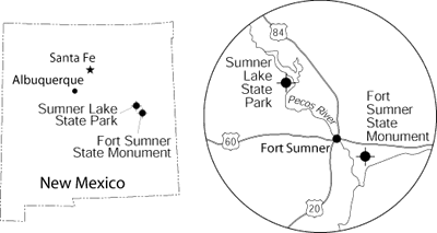
Sumner Lake State Park is approximately 16 miles northwest of Fort Sumner on US–84 and NM–203 at the junction between the Pecos River and Alamogordo Creek (Fig. 1). It was established in 1960 as Alamogordo Reservoir; the name was changed in 1974 to avoid confusion with the growing town of Alamogordo in south-central New Mexico. Sumner Lake was named after nearby Fort Sumner, which honors Col. Edmund Vose Sumner, who commanded the 9th Military District and built Forts Craig, Union, Thorn, and Fillmore (Julyan, 1996). Alamogordo (Spanish for big cottonwood) Creek was named after the abundant, large cottonwood trees along the river valleys (Julyan, 1996).

Alamogordo Dam was built in 1936-1937 by the Bureau of Reclamation to impound water of the Pecos River for the Carlsbad Irrigation District (Young, 1984). This district had been established in 1888 as a private corporation but in 1906 was taken over by the Federal government after a series of floods bankrupted the district (Young, 1984). The dam is a zoned earthen structure with height of 164 ft, width of 30 ft, base width of 925 ft, and a crest length of 3,084 ft at an elevation of 4,301 ft. The dam contains approximately 2.25 million yards3 of rock and dirt.
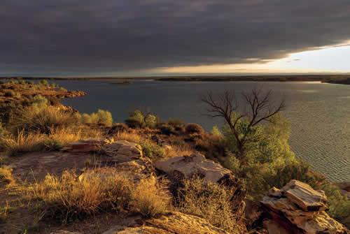
Sumner Lake State Park ranges in elevation from 4,275 to 4,500 ft. Piñon, juniper, mesquite, grasses, and yucca cover the hillslopes and mesas surrounding the lake (Fig. 2), and various wild flowers and cacti, including cholla and prickly pear, are common. Cottonwood trees grow along Alamogordo Creek and the Pecos River. Falcons, mountain bluebirds, ducks, and geese are plentiful. A few bald eagles inhabit the area as well. Antelope and deer roam the countryside. The State Game and Fish Department stocks the lake with walleye and northern pike, large-mouth bass, catfish, crappie, green sunfish, and bluegills. Trout are found in the river below the dam.
Geology

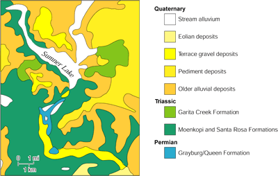
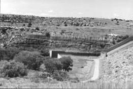
Sumner Lake State Park is in the Pecos Valley section of the Great Plains physiographic province. Rocks exposed in Sumner Lake State Park range in age from Permian to Quaternary (Fig. 3). Sandstones form ledges and cliffs surrounding Sumner Lake (Fig. 4); shales and mudstones form the slopes and are typically vegetated. The red color of the rocks is from trace amounts of red iron oxides that occur as discrete mineral grains and as disseminations in other iron-bearing minerals.
The oldest unit exposed in the park is the Grayburg–Queen Formation (Permian), which consists of reddish-brown mudstones and shaly gypsum with thin dolomitic limestone interbeds. This unit is less than 100 ft thick and crops out along the canyon walls of the Pecos River, both north and south of Sumner Lake (Kelley, 1972). These rocks were deposited by less-saline waters on the north edge of the Artesia shelf of the Permian Basin (Kelley, 1972). The Artesia shelf was one of many marine deposits formed during Permian times when a shallow marine sea covered much of southeast New Mexico.

Most of the rocks surrounding the lake, including those that form the bedrock of the dam, belong to the Middle Triassic Moenkopi Formation and the Upper Triassic Chinle Group. The Moenkopi Formation consists of grayish-red, cross-bedded sandstones, siltstones, and mudstones. Fossil amphibians have been found in the Moenkopi Formation (Lucas and Morales, 1985). The dam is built on the Moenkopi and Santa Rosa (Chinle Group) Formations.
The Chinle Group consists of alternating layers of red-brown to maroon to gray mudstone, siltstone, and sandstone that were deposited in continental fluvial and lacustrine environments about 220 million years ago. The Chinle Group is divided into five formations in eastern New Mexico: Santa Rosa, Garita Creek, Trujillo, Bull Canyon, and Redonda Formations (Lucas, 1995). Only the Santa Rosa and Garita Creek Formations are exposed at the park. The crossbeds in the sandstone are consistent with fluvial deposition. Mudcracks indicate that the mudstones were exposed to drying prior to becoming rock. Oxidation of iron in the minerals forming the sandstone is common to seasonally arid environments such as existed at the time the Chinle Group was deposited.
The Santa Rosa Formation is the basal member of the Chinle Group, and unconformably overlies the Grayburg–Queen Formation. The unit consists of approximately 300 ft of maroon to reddish-brown to tan sandstone, siltstone, and mudstone (Fig. 2). Locally, the sandstones and siltstones are crossbedded and contain ripple marks that indicate the rocks were deposited in stream channels and on floodplains as overbank deposits in alluvial and deltaic environments. Some tree branches, fossil leaves, and other plant remains were found locally in sandstones and mudstones. The Santa Rosa Formation was deposited in a semiarid continental environment, probably wetter than the present climate (Lucas and Hunt, 1987, Lucas and Morales, 1985). Excellent exposures crop out in the dam spillway and form the steep canyon walls along the Pecos River below the dam (Fig. 3). Elsewhere in the subsurface of eastern New Mexico, the Santa Rosa Formation is an oil producer (Broadhead, 1984). The Garita Creek Formation of the Chinle Group conformably overlies the Santa Rosa Formation (Fig. 2). This unit consists of maroon to reddish-brown mudstone, siltstone, and thin sandstone. These rocks were deposited in lacustrine and fluvial environments. Rocks of the Chinle Group form most of the vegetated slopes.
Surficial deposits of soil, gravel, silt, and clay of late Tertiary and Quaternary age cover the Triassic rocks in places. Most of these materials were deposited during the past 2 million years as the Pecos River cut its present valley. Along some valleys in the area, the alluvial fill may be as thick as 60 ft. The terraces along the Pecos River below the dam consist of coarse gravels of quartzite, schist, gneiss, and sandstone that were eroded from the Sangre de Cristo Mountains and deposited by the river over the last million years or so. Sand dunes are also common locally in the state park and were formed in modern times by wind-blown material.
References
- Broadhead, R. F., 1984, Subsurface petroleum geology of Santa Rosa Sandstone (Triassic), northeast New Mexico: New Mexico Bureau of Mines and Mineral Resources, Circular 193, 22 pp.
- Julyan, R., 1996, The place names of New Mexico: University of New Mexico Press, Albuquerque, 385 pp.
- Kelley, V. C., 1972, Geology of the Fort Sumner sheet, New Mexico: New Mexico Bureau of Mines and Mineral Resources, Bulletin 98, 55 pp.
- Lucas, S. G., 1995, Triassic stratigraphy and chronology in New Mexico: New Mexico Geology, v. 17, no. 1, pp. 8–13, 17.
- Lucas, S. G., and Hunt, A. P., 1987, Stratigraphy of the Anton Chico and Santa Rosa Formations, Triassic of east-central New Mexico: Journal of the Arizona–Nevada Academy of Science, v. 22, pp. 21–33.
- Lucas, S. G., and Morales, M., 1985, Middle Triassic amphibian from basal Santa Rosa Formation, east-central New Mexico; in Lucas, S. G., and Zidek, J. (eds.), Santa Rosa–Tucumcari Region: New Mexico Geological Society, Guidebook 36, pp. 56–58.
- Young, J. V., 1984, The state parks of New Mexico: University of New Mexico Press, Albuquerque, 160 pp.


