


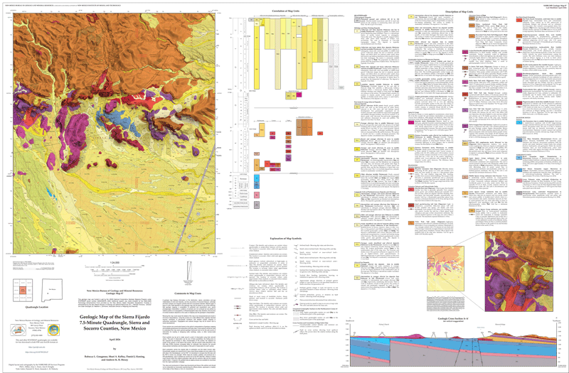
GM-87 — Geologic Map of the Sierra Fijardo 7.5-Minute Quadrangle, Sierra and Socorro Counties, New Mexico
We are a research and service division of:
By: Goughnour, Rebecca L.; Kelley, Shari A.; Koning, Daniel J.; Hoxey, Andrew K. R., 2026, scale 1:24,000
$10.00
Buy
Now
Also available as a free download.
Download
The map and accompanying booklet may be downloaded free of charge.
| File Name | Size | Last Modified |
|---|---|---|
| GM-87_SierraFijardo.pdf | 7.63 MB | 05/01/2026 03:56:47 PM |
| GM-87_SierraFijardo.ppkx | 9.63 MB | 04/06/2026 10:39:35 AM |
| GM-87_SierraFijardo_Report.pdf | 677 KB | 05/01/2026 03:56:53 PM |
Notes:
Geologic mapping of this and other 7½-minute quadrangles in New Mexico is being cooperatively funded by the USGS through the STATEMAP program and with matching funds from the Bureau. For a list of quadrangles in this series, please visit the Open-file Geologic Map (OF-GM) page or try our search page for geologic maps of any series.
These maps are open-filed as they become available, initially as PDF files of scans of the hand-drawn linework and later as full color maps and GIS products. Following cartographic production and editorial review, these maps may be published within our GM-series or be included in larger maps of regions of particular interest.
These maps are subject to frequent revisions and may be unavailable when being revised. Map Reference dates show the time of initial compilation; Map Revision dates, when given, indicate the most current version of the map; Last Modified dates for files may not accurately reflect the time the map was last revised.
-
FONTS
- Many of our Geologic Maps use the USGS FGDC Fonts. If you are accessing the GIS files, please download these fonts and install them on your computer before opening the GIS Project. This will ensure you get the correct symbology for the features in the map.
- Download FGDC Fonts
- Before you open our GIS Map Project Packages, you will need to install the FGDC Geologic Symbology Fonts.
- Right-click on the FGDCGeoSymFONTS.zip.
- Unzip the compressed fonts package by right-clicking on the zip file and selecting “Extract All…”
- Once extracted and the folder opens, select all of the fonts.
- Right-click and select install fonts.
-
GeMS
- Additionally many of our Geologic Maps are in the USGS GeMS Data Model.
There are a few places where the NMBGMR varies from GeMS. These variations are as follows:
- This is an Open-File Geologic Map and has not undergone the highest level of external peer review of publication so that we can get the geologic information out in as timely a manner as possible. This geologic map is presented “as is.”
- The New Mexico Bureau of Geology and Mineral Resources (NMBGMR) has created this GeMS compliant geodatabase or as near as we can get from our understanding and needs.
-
Additions or deviations from GeMS are listed below.
- FGDC_Symbols data table added to geodatabase. This is used to provide consistent descriptions of the symbols used in the database and their definition and for building the Explanation of Map Units legend.
- In the DMU the Symbol field is used as a complete legend description of each map unit and heading, and as such, is a combination of the HierarchKey, ParagraphStyle, MapUnit, FullName, and Description fields so that the legend can be made in the layout with all of this pertinent information sorted as the author intends.
- As such, the Symbol field in MapUnitPolys, MapUnitLines, and MapUnitPoints is not calculated off of the DMU Symbol field as described in the GeMS documentation. It is instead a human-readable version of the Label field where we record the capital geologic time letters as plain text instead of FGDCGeoAge font symbols in addition to any ?, /, or + used in the “label” field. The map unit symbology based on the MapUnit field can be found in an accompanying style file.
- ObservedMapUnit field added to the following point feature classes: GenericPoints, GenericSamples, OrientationPoints, and GeochronPoints. This is only required for the Stations feature class in GeMS.
- Label field has been added to DataSourcePolys.
- Additionally many of our Geologic Maps are in the USGS GeMS Data Model.
There are a few places where the NMBGMR varies from GeMS. These variations are as follows:
-
ACCESS AND USE LIMITATIONS
- Any use of this geologic map, directly or indirectly, or for the purpose of generating derivative products, must include a citation to the Authors, the Publisher (The New Mexico Bureau of Geology and Mineral Resources), the published year, the map series and number, and any contributing agencies like the USGS, with regard to maps that were partially funded under the STATEMAP program.
Please direct comments or requests regarding these maps to either the map authors or the Geologic Mapping Program Manager.