


Overview of Fresh and Brackish Water Quality - Raton-Las Vegas Basins
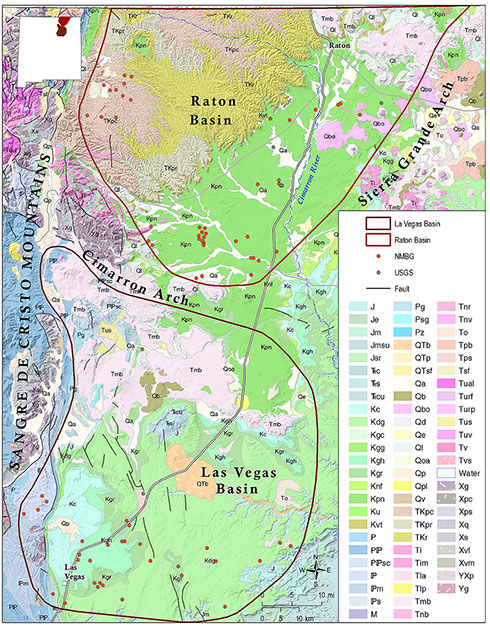
Northeastern New Mexico is a geologically diverse area that includes the upper Pecos and Canadian river valleys, the eastern margin of the Sangre de Cristo Mountains, and the Raton and Las Vegas Basins, two north-trending assymetric structural basins formed during the late Cretaceous-Paleogene Laramide orogeny. The Raton and Las Vegas Basins are separated by igneous intrusive rocks of the Cimarron Arch, near Cimarron, NM. The gently-dipping eastern margins of these basins are defined by the Sierra Grande Arch and the Raton-Clayton volcanic field (Kelley, 2015; Broadhead, 2015).
The Raton-Las Vegas Basin region includes eastern Colfax County, Mora County, and San Miguel County, New Mexico. Large supplies of groundwater are generally not available in this region. The two largest communities in northeastern New Mexico, Raton and Las Vegas, derive most of their water from surface diversions, although the city of Las Vegas has supplemental water supplies from wells completed in the Permian Glorieta and Triassic Chinle and Santa Rosa sandstones (Lazarus and Drakos, 1997). Wells completed in volcanic rocks near Capulin, New Mexico have also yielded significant volumes of fresh water (Dinwiddie and Cooper, 1966).
Most of the groundwater resources in the region occur in Triassic through Cretaceous sandstones, the most prolific of which is the Dakota sandstone in eastern Colfax and Union Counties (Dinwiddie and Cooper, 1966; Kilmer, 1987). The poor quality of water in the Dakota sandstone aquifer west of the Rio Grande Arch has been attributed to the presence of subsurface dikes that have added dissolved solids such as bicarbonates, chlorides, and sodium to Dakota sandstone waters (Griggs, 1948). TDS content greater than 3,000 mg/l has been reported in some wells screened in the Dakota sandstone in the Las Vegas Basin (Lazarus and Drakos, 1997).
Groundwater in northeastern New Mexico has been relatively underinvestigated compared to other regions of the state. Rawling (2014) reported on water resources in the Ogallala and upper Dakota Formations in eastern Union Co. Prior to that report, the most comprehensive investigations of water resources in northeastern New Mexico were conducted in the mid-20thcentury by workers with the New Mexico Bureau of Mines and Mineral Resources (Griggs, 1948; Griggs and Hendrickson, 1951; Cooper and Davis, 1967).
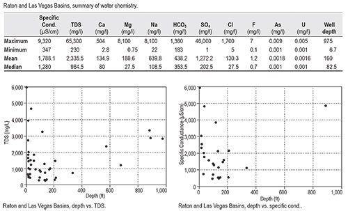
Data coverage for the Raton and Las Vegas Basins combined is very limited, with a total of only 80 records. Groundwater quality in the region is brackish, with a mean TDS concentration of 2,336 mg/l. However, the mean TDS for the region is influenced by one well located adjacent to a saline playa at Maxwell National Wildlife Refuge, with a measured TDS concentration of >65,000 mg/l. The median TDS of 965 mg/l may be more representative of basin-wide mineral content. Plots of TDS and specific conductance vs. depth indicate that brackish water resources are probably present at greater depths in the Raton-Las Vegas Basin region. However, with an average well depth of only 160 feet, this resource is largely unexplored.
This project is funded by the New Mexico Environment Department, Drinking Water Bureau, under Source Water Protection.
For more information:
see: Overview of Regional Brackish Water Assessments
or contact:
Lewis Land — Hydrogeologist, lland@nckri.org
References
- Land, Lewis, 2016, Overview of Fresh and Brackish Water Quality in New Mexico - Raton-Las Vegas Basins, Project Summary Sheet.
- Land, Lewis, 2016, Overview of Fresh and Brackish Water Quality in New Mexico, New Mexico Bureau of Geology Mineral Resources, Open-file Report, v. 0583, pp. 55.