


Petroglyph National Monument
We are a research and service division of:
Location
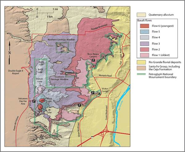
Petroglyph National Monument is located on Ceja Mesa on the west side of Albuquerque. The Las Imagines Visitor Center can be accessed from downtown Albuquerque by traveling west on I-40, taking exit 154, and driving north on Unser Boulevard about 3.5 miles. The visitor center is located near the intersection of Unser Boulevard and Western Trail. Turn left at the stoplight at the intersection and drive up the road to the parking lot for the visitor center (Figure 1). The Volcanoes Day Use area can be reached by driving west from Albuquerque on I-40 and exiting at Paseo del Volcan (Exit 149). The Volcanoes Day Use area is 4.8 miles north of I-40 on the east side of Paseo del Volcan (Figure 1).
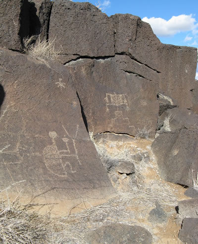
Petroglyph National Monument is best known for the estimated 25,000 rock art images carved into basalt erupted from the approximately 200,000-year-old Albuquerque volcanic field (Figure 2). Using stone chisels and hammer stones, the ancestors of the Puebloan Indians cut most of the petroglyphs into the desert varnish coating the basalt between 1300 and 1680 A.D. A few of the markings are much older, dating back to perhaps 2000 B.C. Spaniards and later generations of Albuquerque inhabitants have produced younger petroglyphs with more modern themes. The monument, created in 1990, includes about 17 miles of petroglyph-covered basalt cliffs and five extinct volcanoes.
Regional Geologic Setting
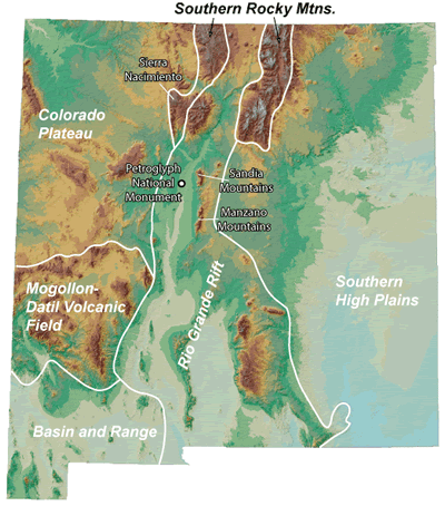
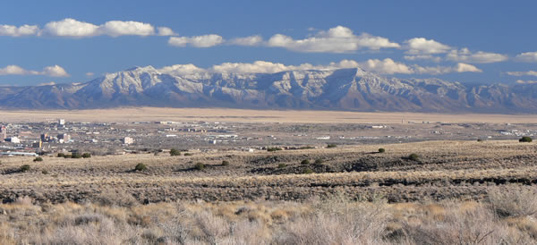
The Albuquerque volcanic field is only seven miles west of downtown Albuquerque. The volcanic field is in the western Albuquerque Basin of the Rio Grande rift (Figure 3). This basin is just one of a series of linked basins between central Colorado and west Texas that formed when the earth’s crust extended or stretched in an east-west direction starting about 36 million years ago in the southern part of the rift. As extension was accommodated by normal faults, deep basins and prominent rift-flank uplifts formed. The monument offers spectacular views of the Sandia Mountains directly to the east and Manzanita and Manzano Mountains to the southeast (Figures 3 and 4). These east-tilted rift-flank ranges on the eastern margin of the Albuquerque Basin rise as much as 5700 feet above the elevation of the Rio Grande, exposing Precambrian granitic and metamorphic rocks on the west side, with Pennsylvanian limestone and shale capping the mountain blocks. The western margin of the Albuquerque Basin is a subtle topographic feature that lies about 12 miles to the west of the monument on the west side of the Rio Puerco, where Cretaceous marine sedimentary rocks are faulted against rift-fill sediments. The volcanoes formed along faults near the center of the basin, perhaps in a place where the crust is most thinned by extension.
Geologic History
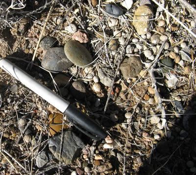
Extension in this part of the Rio Grande rift began about 26 million years ago. Sediments that eroded from the developing rift-flank highlands accumulated in the Albuquerque Basin. These basin fill deposits, known as the Santa Fe Group, are over 16,000 feet thick beneath the Albuquerque volcanoes. The uppermost sand and gravel member of Pliocene to early Pleistocene Ceja Formation, the youngest unit of the Santa Fe Group in this part of the basin, was deposited by streams draining the area to the west and northwest of the monument (Love and Connell., 2005). The light brown-to-yellow-brown sand and gravel deposit includes well-rounded cobbles and pebbles of granite and quartzite derived from Precambrian rocks, chert and petrified wood eroded from Triassic sedimentary rocks, and rare volcanic rocks (Figure 5). One very distinctive clast in this gravel is Pedernal chert that is likely eroded from the northern part of the Sierra Nacimiento (Figure 3).
The Llano de Albuquerque, a flat surface that developed on top of the Ceja Formation, represents the maximum basin fill of the Albuquerque Basin at the end of Santa Fe Group deposition about 1.8 million years ago (Connell et al., 2007). This surface is about 705 to 360 ft above the modern Rio Grande floodplain. The Llano de Albuquerque surface formed during a period of landscape stability.
The Rio Grande started to cut down through the older Santa Fe Group deposits about 1.2 to 0.7 million years ago in response to both climatic changes and integration of the river system (Connell et al., 2007). This downcutting was not a continuous process; there were several episodes of downcutting, aggradation, and renewed incision. This episodic development of the river system led to the formation of four terrace levels along the Rio Grande in the Albuquerque area. Tributaries to the main river later deposited valley alluvium along the margins of the Rio Grande floodplain. The tops of the terrace and valley alluvium deposits are at levels about 140 feet to a few tens of feet above the modern elevation of the Rio Grande. The terrace deposit in the monument, which is called the Los Duranes Formation, is made up of brown-to-reddish-brown sand, gravel, and clay (Connell, 2008). Two generations of sandy and gravelly valley alluvium are inset into the Los Duranes Formation (Connell et al., 2007; Connell, 2008).
About 210, 000 to 155,000 years ago (Peate et al., 1996; Smith et al., 1999), basaltic magma from deep within the earth migrated up along the fractured rock in the vicinity of a significant rift-related fault; the fault is named the County Dump fault for good exposures of this feature at the local landfill (Bauer et al., 2003). The weakened, fractured rocks around the fault acted as conduits, allowing the molten rock to come to the surface. The fault has not moved significantly in the last 20,000 years, but a small earthquake (magnitude 4.4) was recorded along this fault in 1971 (Bauer et al., 2003).
Five large cones and at least 10 small volcanoes and spatter cones have been recognized in the Albuquerque volcanic field (Kelley and Kudo, 1978; Crumpler, 1999; Smith et al., 1999). Six basalt flows erupted from the aligned spatter cones and fissures that developed along two en echelon north-south striking fault segments (Lambert, 1968; Kelley and Kudo, 1978). The fissures and spatter cones shot fountains of ash, cinders, and lava about 30 feet into the air (Smith et al., 1999). The first eruption along the fissures sent lobes of fluid lava that moved slowly (5-10 mph; Bauer et al., 2003) downslope to the east and southeast into the Rio Grande valley, covering the Llano de Albuquerque surface and the younger terrace and valley alluvium deposits. The lava from the second eruption covered a larger area than the first flow, rolling toward the northeast, east, and southeast, again into the river valley. There was a pause in activity and thin sediments were deposited. When activity was renewed in the Albuquerque volcanic field, the style of eruption changed. The magma was slightly more viscous (i.e. more sticky), so that the lava flowed both east and west of the main fissure, but the lava did not flow very far (Figures 1 and 6). The flows from the final three eruptions were localized around the vents (Figure 1).
Geologic Features
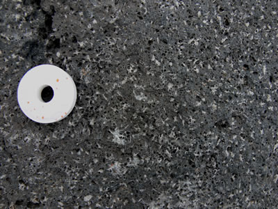
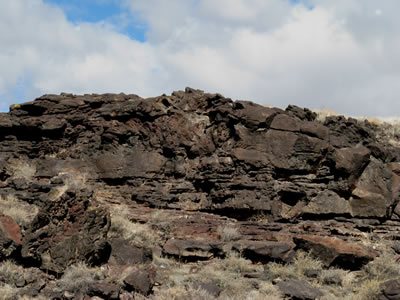
Several of the basalt flows that erupted from the cones contain abundant white plagioclase crystals that are easily visible to the naked eye (Figure 7). Generally the tops and bottoms of the individual flows are full of holes called vesicles, which formed as gas bubbles escaping from the cooling lava were trapped and preserved in the rock (Figure 7). The tops of the flows variably have a ropy (pahoehoe) or a rubbly (aa) texture. Wind-blown spatter and cinder deposits, frozen lava lakes, and small lava tubes are among the well-preserved volcanic features that can be viewed in the monument (Smith et al., 1999; Crumpler, 1999).
The volcanoes on Ceja Mesa are aligned along two segments that trend in slightly different directions. The southern segment, which strikes 2° east of north, includes, from south to north, the JA, Black, and Vulcan cones (Kelley and Kudo, 1978). The trail system of the Volcano Day Use area meanders through this southern set of cones. One of the southern-segment cones named Cinder, which was south of JA cone, has been mined out of existence. Cinder from the cones was mined for railroad bed material, cinder blocks, and landscaping material. The northern set of cones, including Butte and Bond cones, is offset to the west of the southern segment by about 650 feet and strikes 3° east of north (Kelley and Kudo, 1978). These cones are harder to visit because there are no trails.
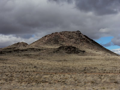
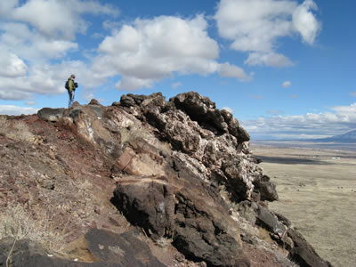
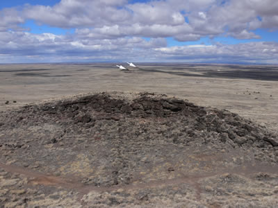
The largest of the cones in the Albuquerque volcanic field is Vulcan (Figures 6 and 8), named after the Roman god of fire. From a vantage point on top of the cone 200 feet above mesa, the alignment of the 5-mile-long chain of vents is particularly noticeable. Vulcan is a spatter cone, formed primarily by fire fountains that were active in the central vent and in smaller vents on flanks of the cone (Smith et al., 1999). Spatter forms when blobs of lava are emitted from a vent. The blobs cool as they fly through the air, and the partially molten blobs then land on the side of the cone to weld together to form a hard crust. Fragmental cinder and spatter material and lava flows dip at angles as high as 55° away from the central vent on the eastern and southern side of the Vulcan (Figure 8; Smith et al., 1999). The spatter material is thickest on the southeastern side of Vulcan, indicating that it was blown by the wind toward the south and east during the fountaining events. A solidified lava pond that consists of a massive gray basalt with weakly-developed columnar jointing occupies the crater of Vulcan (Figures 9 and 10). Modern graffiti has been carved into this flow on the west side of the cone. Radial, sinuous lava tubes 8 to 20 inches across and 300 feet long are preserved on the northeast and northwest flanks of Vulcan.
A classic example of inverted topography is preserved on the east side of the monument. Basalt from the Albuquerque volcanoes once filled in low spots along the edge of Rio Grande valley about 200,000 years ago. Subsequent downcutting by the Rio Grande has now formed a mesa capped by basalt. Erosion of the soft sediments under the hard basalt has caused large blocks of basalt from the two older flows to tumble down the eastern escarpment of the mesa. Most of the petroglyphs are on these large basalt blocks. The petroglyphs are chiseled into a black, metallic-looking patina on the basalt called desert varnish. This coating forms in arid environments on protected surfaces that are resistant to weathering. Desert varnish is composed mainly of clay mixed with manganese and iron oxides. Organic processes and the evaporation of dew, which causes the concentration of manganese oxide, enhance the formation of desert varnish. The best petroglyphs are along trails in Rinconada Canyon to the south of the Visitor Center and along trails in Boca Negra Canyon and Piedras Marcadas Canyon to the north of the Visitor Center.
Two small erosional windows cut by streams through the basalt flows are included within Petroglyph National Monument (Figures 1 and 11). There are no formal trails or parking areas to access these windows, but the erosional windows can be reached by hiking along arroyos. The northern window can be accessed via dirt roads located south of Paseo del Norte NW or by walking up North Boca Negra Arroyo. The southern window can be reached by walking along South Boca Negra Arroyo. The basalt flows are thin in the vicinity of these windows compared to areas to the north and south, suggesting that there might have been small hills on top of the Ceja Formation prior to the eruption of the Albuquerque volcanoes. Basal flow features and flow breaks are well-exposed in these windows. Although the Ceja Formation is poorly exposed in these drainages, pebbles and cobbles of granite, quartzite, and chert litter the slopes below the lava flows (Figure 5). A few petroglyphs were carved into the basalt flows of the geologic windows (Figure 2).
References
- Bauer, P.W., Lozinsky, R.P., Condie, C.J., and Price, L.G., 2003, Albuquerque: A guide to its geology and culture: New Mexico Bureau of Geology and Mineral Resources Scenic Trip 18, 182 pp.
- Connell, S.D., 2008, Geologic map of the Albuquerque–Rio Rancho metropolitan area and vicinity, Bernalillo and Sandoval Counties: New Mexico New Mexico Bureau of Geology and Mineral Resources Geologic Map GM-78, scale 1:50,000, 2 sheets.
- Connell, S.D., Love, D.W., and Dunbar, N.W., 2007, Geomorphology and stratigraphy of inset fluvial deposits along the Rio Grande valley in the central Albuquerque basin, New Mexico: New Mexico Geology, v. 29, n. 1, p. 13-31.
- Crumpler, L.S., 1999, Ascent and eruption at the Albuquerque volcanoes: a physical volcanology perspective: New Mexico Geological Society Guidebook 50, p. 221-233.
- Kelley, V.C., and Kudo, A.M., 1978, Volcanoes and related basalts of Albuquerque Basin, New Mexico: New Mexico Bureau of Geology and Mineral Resources Circular 156, 30 pp.
- Lambert, P.W., 1968, Quaternary stratigraphy of the Albuquerque area, New Mexico [Ph.D. thesis]: Albuquerque, University of New Mexico, 329 p.
- Love, D.W., and Connell, S.D., 2005, Late Neogene drainage development on the southeastern Colorado Plateau, New Mexico: New Mexico Museum of Natural History and Science Bulletin 28, p. 151-169.
- Peate, D.W., Chen, J.H., Wasserburg, G.J., and Papanastassiou, D.A., 1996, 238U-230Th dating of a geomagnetic excursion in Quaternary basalts of the Albuquerque volcanoes field, New Mexico (USA): Geophysical Research Letters, v. 23, n. 17, p. 2271-2274.
- Smith, G.A., Florence, P.S., Castounis, A.D., Luongo, M., Moore, J.D., Throne, J., Zelley, K., 1999, Basaltic near-vent facies of Vulcan Cone, Albuquerque volcanoes, New Mexico New Mexico Geological Society Guidebook 50, p. 211-219.