


Permian Reef Complex Virtual Field Trip
Stop II-1: McKittrick Canyon Reef-Basin Transect
We are a research and service division of:
McKittrick Canyon Visitor's Center parking area. We will walk up the canyon for a short distance (about 3/4 km; 1/2 mi) following the trail marked for "Pratt's Lodge" and then return via the streambed; we will then take the geology trail which was cut in the early 1980's up the north side of McKittrick Canyon. We will be undertaking an approximately 350 m (1,200 ft) climb on this well graded but rocky trail, so please wear sturdy hiking boots. Also remember that we are now in the Guadalupe Mountains National Park and rock hammering or even collecting of loose rock samples or stream cobbles is not allowed without a specific collecting permit. Finally, the difficulty of the terrain and the size of the group make it imperative that we all stay on the clearly marked trail and remain together as a group. PLEASE, DO NOT WANDER OFF ON YOUR OWN OR IN SMALL SUBGROUPS. We will keep the pace slow enough so that all can keep up.
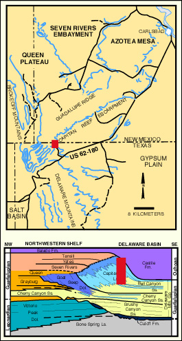
The purpose of this stop is to examine the toe-of-slope and fore-reef facies transitions of the Capitan Limestone and its equivalents. Although it would be more pleasant if this facies change could be seen without resorting to a strenuous climb, this is not possible. It must be remembered that the facies transition is one which took place on a 30 degree slope over a vertical distance of more than 400 m (1,300 ft); thus, the vertical component is an important one. Also, these facies are exposed only in areas south of White's City and are easily accessible only in Rattlesnake, Slaughter, and McKittrick Canyons. All three areas require extensive climbing and McKittrick provides the easiest access coupled with excellent lateral exposure.
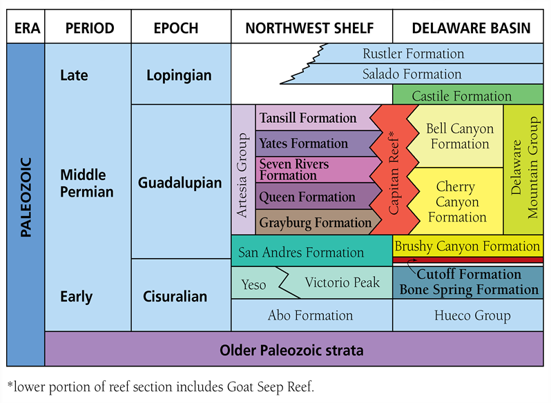
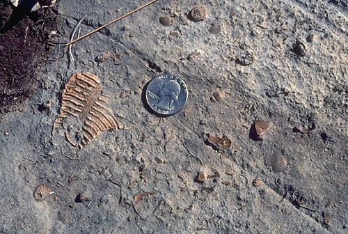
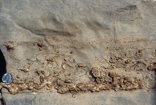
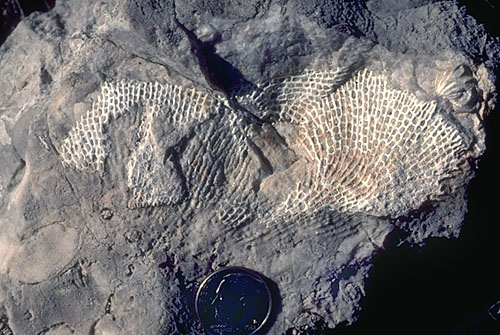
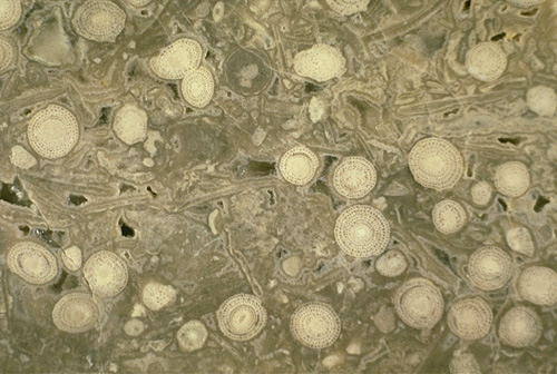
Our upward climb will take us across a number of different Bell Canyon units (see stratigraphic nomenclature diagram). We start at the level of the Rader Limestone, and cross several unnamed Bell Canyon sandstone units, and the McCombs Limestone before reaching the Lamar Limestone. We will then ascend essentially along a Lamar-Capitan dip-slope and view the lateral changes in Lamar to slightly post-Lamar (Tansill-equivalent) talus facies (see photo). For a short interval, just below the massive triangular spur of reefal material, we will be in slightly older, Yates-equivalent strata (Bebout and Kerans, 1993). We start our walk on the Pratt Lodge trail in slope alluvium with some outcrops of the McCombs Member but soon reach the thin-bedded, dark-colored, micritic limestones of the Rader Limestone in the stream bed. Bryozoans and brachiopods are the most commonly seen megafossils in the Rader carbonates. Chert nodules and silicified (originally calcitic) organisms abound (see photo) with the silica having been derived from siliceous sponges and radiolarians that lived or accumulated in the down-slope area. In other areas of the Permian Basin, equivalent strata have yielded even more spectacular faunas (see photo).
© Peter A. Scholle, 1999
© Peter A. Scholle, 1999
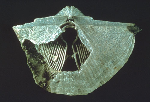
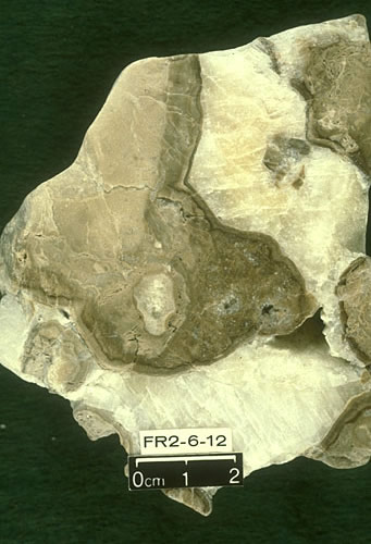
Sample from Smithsonian Institution collections.
© Peter A. Scholle, 1999
The only other macroscopic diagenetic feature visible is compactional deformation around fossils, concretions, nodules, or allochthonous blocks of reefal debris (see photo). Thin- to medium-bedded graded carbonate turbidites, channels filled with cross-bedded reef- and slope-derived debris, and large blocks of reef limestone also can be seen locally in these beds.
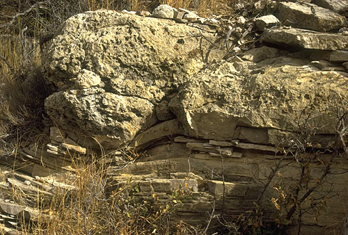
As we move up-stream, we will see thick packages of fine-grained, well-sorted sandstone and siltstone interbedded between the Rader and McCombs limestone members. The sandstones are compositionally identical to the thin, back-reef sandstone and siltstone units we will see at other localities. In addition, several large carbonate blocks of reef and upper slope material can be seen within the sandstones these represent rock falls or slides on the fore-reef slope (see photo above). One must take care, however, because the stream bed is also lined with patches of well-cemented fluvial gravels of recent origin.
The up-slope interfingering of discrete, basinward-dipping Permian sandstone and carbonate units indicates that both were derived from the shelf. The sandstones also show extensive evidence of down-slope current transport including large-scale trough cross-bedding, channels, ripple marks, and other features. Just a few hundred meters farther up-slope, the sandstones become thinner and eventually pinch out entirely. The carbonate units, on the other hand, become progressively more massive and coarser-grained in an up-slope direction (see photo above).
Return via the trail (or the stream bed) to the geology trail which departs from just east of the stream valley near the Visitor Center.
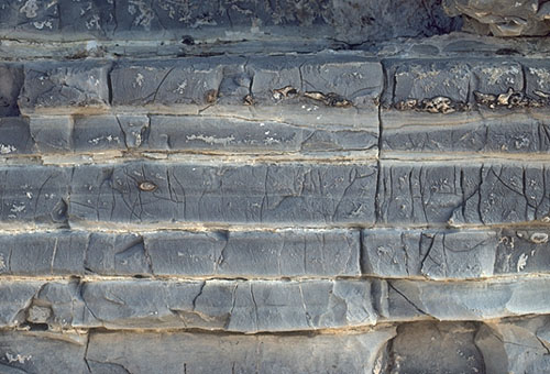
The *Permian Reef Geology Trail initially rises rapidly through consolidated stream gravels and dark-colored, very fine-grained limestones of the Lamar Member of the Bell Canyon Fm. Note the abundance of chert nodules (common only in this toe-of-slope setting, occasional debris beds, and burrowed limestones. These beds dip basinward at angles of 7 to 10°, just a few degrees steeper than the regional dip. Turn left (upslope) at the trail junction of the Permian Reef and Geology Loop trails. Do NOT take the trail marked "Geology Loop". After taking a small left-hand jog at the second junction with the Geology Loop trail, we will pass cliffs of lower slope Capitan-Lamar transition beds. Moving upslope through these strata you will be able to see generally dark-colored limestones that are thin-bedded (see photo) or have irregular stylonodular bedding (see photo). Some graded beds and intensely bioturbated, dark colored limestones are also visible. Lack of early cementation in these strata led to extensive porosity loss during burial as a consequence of both chemical and mechanical compaction.
© Peter A. Scholle, 1999
© Peter A. Scholle, 1999
© Peter A. Scholle, 1999
© Peter A. Scholle, 1999
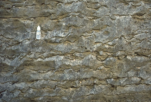
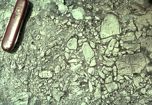
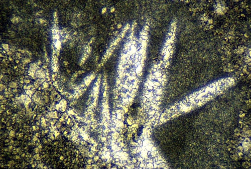
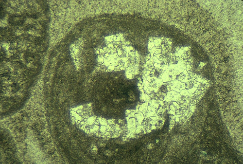
After passing through a deep cleft in the rocks (with a diverse flora including prickly pear, ocotillo, Texas madrone, and scrub oaks), you will pass medium-bedded Lamar-Capitan limestones with superb fining-upward (graded turbidite) fabrics (see photo). Much of the reworked slope and reef fauna in these detrital beds has been selectively replaced by silica (chert and chalcedony). At the first sharp switchback in the trail, note the massive bedded unit which has highly irregular (lenticular bedding). This is the first of many debris flow units we will see along the trail. Most debris flows fill sinuous slope channels and thus have highly lenticular bedding (see photo); many are also closely associated with turbidite deposits. The carbonate grains and blocks in these deposits are clearly recognizable as reef- and slope-derived skeletal fragments (see photo). The fact that this is primarily reef rubble is clear from the abundance of original framework producing organisms, such as calcareous sponges and bryozoans, as well as the organic encrustation and submarine cementation of many of the clasts. In most areas, these debris-flow units have little obvious internal organization of the clasts. In the short stretch leading to the second trail switchback, you should be able to see some surfaces with excellent reefal fabrics (calcareous sponges, Archaeolithoporella encrustations, and marine cement). In addition, there are sharply bounded areas (especially well displayed right at the second switchback) with lighter tan, more crystalline carbonate with numerous patches of coarse, sparry calcite. The diagenesis of these irregularly-shaped, highly altered zones is complex. Many of the detrital clasts of calcareous debris underwent submarine cementation in their original environment of formation. Subsequent alteration in the down-slope depositional environment included extensive selective dolornitization (the tan-colored material), leaching of aragonitic grains, brecciation (see photo), and medium-crystalline calcite "cementation".
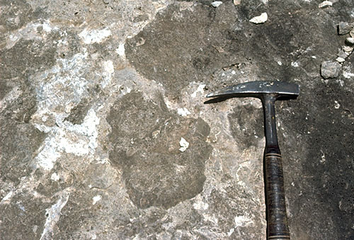
Photo courtesy of Sal Mazzullo.
© Peter A. Scholle, 1999
The dolornitization of the Capitan slope is highly variable on both local and regional scales (Melim and Scholle, 1992; Melim and Scholle, 1999; Scholle et al., 1993) — farther south, near El Capitan and Guadalupe Peak, nearly 100 percent of the slope material has been dolomitized, but in this area, less than 50 percent of the rock has been replaced. Likewise, coring of equivalent Capitan slope facies farthernorth and east (the PDB-04 well on the northern margin of the Delaware basin) showed a completely dolornitized reef and forereef section (Garber et al., 1989).
© Peter A. Scholle, 1999
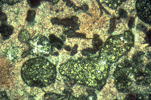
Dolomitization selectively affects finer-grained primary constituents (see photo) and typically is distributed in sharply bounded rock bodies. Vertical, synsedimentary fracture systems and/or solution-enlarged pipes and fractures apparently funneled shelf-derived brines deep into the fore-reef debris. Permeable slope deposits then served as supplementary conduits for lateral movement and selective replacement and/or cementation by these brines (Melim and Scholle, 1989). At least two generations of dolomite have been identified
© Peter A. Scholle, 1999
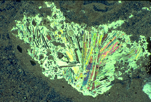
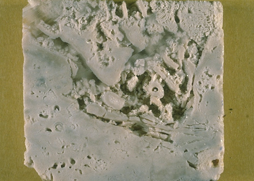
The dolomitized zones are generally associated with coarse, sparry calcite (see photo) and vermicular kaolinite (dickite), both of which form pore filling cements. Although the coarse calcites have long been interpreted as simple burial cements (e.g. Mruk, 1985; Mruk, 1989), recent work has indicated that they are replacements of massive evaporites which once plugged most fore-reef porosity (Scholle et al., 1993). The precursor evaporites (see photo 1 and photo 2) were removed during Tertiary uplift, a time in which surface-derived meteoric fluids were able to penetrate deep into the subsurface from recharge sites in the Guadalupe Mountains. Thus, evaporite minerals are common and calcite spar is scarce to non-existent in still deeply buried sections of the Capitan Fm. The Capitan forereef strata in the PDB-04 well represent an intermediate stage of alteration between the calcitized outcrops and the unaltered deeply-buried strata of the Central Basin Platform. The PDB-04 samples have some preserved anhydrite, common anhydrite relicts within poikilotopic gypsum (see photo), and numerous open voids (see photo) formed by evaporite dissolution (Garber et al., 1989; Scholle and Melim, 1988).
© Peter A. Scholle, 1999
© Peter A. Scholle, 1999
© Peter A. Scholle, 1999
© Peter A. Scholle, 1999
The intense and varied early diagenesis precluded significant compaction in these units, but grain fracturing is common (see photo above), probably as a result of subsurface leaching and local collapse. Porosity in outcrop is quite low, but production has recently been obtained from comparable dolomitized slope facies in the Bone Spring Fm. (see citations in introduction).
© Peter A. Scholle, 1999
As we continue to climb the trail, there are few markers on which to hang a usable trail guide. In general, however, note the increasing size of debris, steepening dips, and lighter color of the debris. Furthermore, extensively encrusted reefal fabrics become more and more dominant upslope, at least until the upper 1/3rd of the slope. Most of this represents allochthonous blocks of debris, ranging from gravel to house-sized. Indeed, some blocks my simply be too large to recognize — this makes picking the exact level of transition to truly in-situ lithified and encrusted reef fabrics is virtually impossible. Reef growth, algal encrustation and inorganic (submarine) cementation extends into water depths of a hundred meters or more (several hundred feet) in many modern tropical reef areas, and similar patterns are to be expected in the Permian. Thus, although the zone of major faunal growth and diversity lay up-slope from the highest point we will ascend to, some in situ growth of upper forereef organisms (especially bryozoans; see photo), algal encrustations, and submarine cementation presumably extended down-slope into the talus areas we are crossing.
© Peter A. Scholle, 1999
Just before and just after the next major switchback (far up the trail, just below the sheer, triangular Capitan face) be sure to note the numerous beds of fusulinid grainstone (see photo). These channelized debris flows were derived from the near-back-reef shelf detritus which probably bypassed the reef through tidal passes or channels (Harwood, 1989). The uppermost part of the slope facies dips very steeply (more than 35° in places) and clearly contains more grainstones than beds in the mid-slope area. This may result from the fact that coarse, blocky rubble may simply not come to rest on such steep, smooth slopes. In modern environments, as in the Permian reeef, the steepest slopes are either sediment free or sand-covered, whereas the coarser debris moves to mid-fan settings (e.g. James and Ginsburg, 1979).
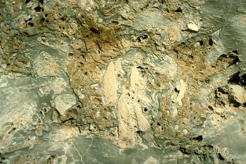
Photo courtesy of Brenda Kirkland-George.
Above the bedded Capitan talus lies a massive, nearly completely unbedded zone of the Capitan reef-massif, best seen directly above us (see photo of the north wall of McKittrick Canyon above). The massive character is a consequence of both the original skeletal framework with its sponge framework, encrusted (boundstone) fabric, and massive, penecontemporaneous cementation which completely pervaded the reef and obliterated most primary porosity. Some of these reef fabrics are seen on the last stretch of trail we will traverse — the zone just below (or at the base of) the massive triangular face. This zone is still several hundred feet below the crest of the reef. We do get into rocks showing sponge-algal-cement boundstones and these may represent spurs of reef that extended well down the steep fore-reef slope. Numerous examples of framework sponges can be seen as one climbs through this section, although some cryptic (cavity-dwelling) sponges (see photo) also are visible here. The undeniable presence of such non-framework sponges has caused some workers (Wood et al., 1994 and 1996) to question the importance of sponges as framework builders in the Permian reef complex, a conclusion that most other workers dispute.
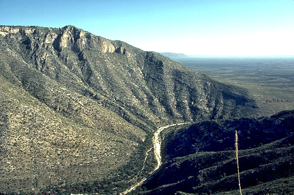
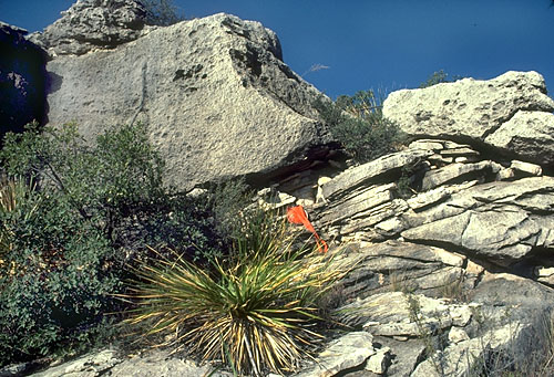
As we climb this final long straight stretch of trail we can look back to the south and southwest and get a better perspective on the true bedding relations in the area. Unfortunately the best perspective is from the south toward the face we are climbing, but even the panorama of the north wall of McKittrick Canyon can be useful. The vast bulk of the sediments which make up the lower 3/4th of the south wall of McKittrick Canyon (as well as the cliff we have climbed) consists of Capitan fore-reef debris. In many areas, particularly near the transition to the reef, the steep dip (nearly 30 degrees) of these rubble beds is apparent. The gradual flattening of those dips to the near-horizontality of the basinal Bell Canyon sediments is equally apparent as one traces individual beds basinward. Indeed, the uppermost basinal limestone (the Lamar) can be traced as a virtually continuous bed from basin to shelf as it rises more than 500 m (1,700 ft).
Although particularly well developed at its eastern end, the reef massif can be traced continuously toward the west. In this direction, the reef passes lower and lower in the section but continues to overlie thick, reef-talus deposits. Thus, from this vantage point we can see that the Capitan reef built upward nearly 1,000 ft during the time in which it prograded out over its own debris; the debris, furthermore, filled in a basin of between 1,000 and 2,000 ft water depth.
The ratio of reef rubble to in situ reef is extremely high, a fact noted by many workers. As pointed out by Dunham (1972), however, this is not a surprising situation. In modern reef-forming areas, the zone of significant reef growth is narrow, both laterally and vertically. The active growth zone is but a thin veneer on the upper and frontal edge of the reef platform. Much of this in situ material is eventually broken up by storms and reworked down the fore-reef slope. New organisms grow in the reef crest area only to be reduced to rubble as well. Vast quantities of material are formed within the reef zone but only a small fraction of this volume remains in that environment. Most is swept away into fore-reef or back-reef settings. Thus, the vast amounts of rubble visible in the Capitan complex are not a valid piece of evidence to deny the existence of a true reef in this area. Rather, the rubble serves as evidence that the shelf edge was occupied by a faunally diverse assemblage of organisms with remarkably high rates of sediment production.
Above and to the west of the Capitan reef-massif, a wedge of flat lying, well bedded, back-reef sediments (Tansill and Yates Fms.) can be seen (see photo of the north wall of McKittrick Canyon above). The wedge thickens to the west where older sediments are exposed. The sediments (mainly green algal-fusulinid grainstones) of the near-back-reef Tansill and Yates formations can be seen to pass into and over the Capitan reef-massif and perhaps even to spill over onto the slope in front of the reef. This may be an indication that reef growth ceased before the end of carbonate sedimentation in the area. In that case, the final phase of shelf-edge deposition would have been marked by unconsolidated skeletal sand shoals rather than a barrier reef. The trail we are on extends through the reef and well up into the back-reef strata but, because of time constraints, we will stop near the fourth switchback. At this point you can see excellent reefal fabrics, plus considerable calcite-filled, solution-enlarged porosity which may be indicative of a period of meteoric exposure of the reef (Given and Lohmann, 1986).
© Peter A. Scholle, 1999
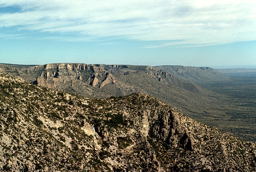
We will walk out on the large rock spur just east of the fourth trail switchback (a major turn that takes the trail behind, or north of, the triangular massive wall). From this vantage point, one can see a superb vista to the north and northeast (see photo). It shows present-day topography which virtually exactly matches that of late Guadalupian time. Back-reef sediments mark the upland surface of the Northwestern Shelf; Capitan reef sediments, characterized by their vertical, strike-parallel jointing, delineate the upper margin or rim of the Delaware basin; steeply dipping slope deposits compose the flanks of the escarpment; and flat-lying basinal deposits of the upper Bell Canyon Fm. compose the floor of the present basin to the east-northeast (the Delaware basin). The exhumation of this Permian topography is entirely a consequence of the evaporite filling of the remnant Delaware basin in Ochoan time, and its subsequent dissolution during the Tertiary.
Note the "rollover" or "fall-in" of the bedded Tansill back reef deposits into or over the late Capitan shelf margin deposits. This relationship has been used to argue for a slighly down-slope site for the main Capitan reef growth. It may, however, rather reflect down-to-the-basin syn- and post-depositional subsidence and/or faulting (see discussions in Saller, 1996, and Longley, 1999). In addition, the overtopping of the reef with bedded strata may indicate that rising salinities near the end of Capitan deposition (and prior to sedimentation of the Castile-Salado evaporites) terminated reef growth while still allowing formation of grainstone shoals at or near the shelf break.
If one turns from the northern view to the east and southeast, a series of cuesta scarps formed by the various limestone members of the Delaware Mountain Group are visible. These culminate in the major escarpment of the Delaware Mountains, capped by the Getaway Limestone.
We now descend the trail following the same route, will eat lunch in the parking lot by the McKittrick Canyon visitor center, and will then retrace our route back to U.S. Highway 62 and 180.
Turn right for El Paso or left for Carlsbad at mileage 113.8 on the El Paso-Carlsbad roadlog.
Return to the Walnut Canyon Roadlog or the El Paso-Carlsbad Roadlog