


Permian Reef Complex Virtual Field Trip
Stop II-5: Bell Canyon Fm. – Basinal Siltstones & Sandstones
We are a research and service division of:
BE CAREFUL TRAFFIC IS ESPECIALLY HAZARDOUS AT THIS OUTCROP!
© Peter A. Scholle, 1999
© Peter A. Scholle, 1999
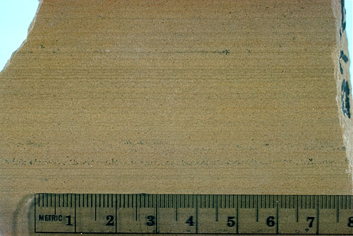
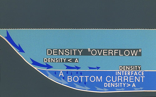
Well-sorted, subarkosic siltstones of the Bell Canyon Formation showing remarkable uniformity of bedding and horizontal lamination (see photo). The Bell Canyon Formation is about 210 m (700 ft) thick at its type locality, but has been reported to be as thick as 260 m (860 ft) in subsurface sections (Hayes, 1964, p. 14). As with the other basinal sandstone units of the Delaware Mountain Group, the depositional mechanisms of the Bell Canyon siltstones and sandstones have been extensively debated. The abundance of horizontal lamination and the apparently euxinic conditions in the basin center lend credence to the idea of density overflows and suspension deposition of much of the sand and silt (see photo). On the other hand, the presence of numerous subparallel erosional channels, many of them oriented from northeast to southwest but many others also oriented perpendicaular to the nearest shelf margin (see figure), indicates that sea floor erosion, transportation, and deposition by long-lived density underflows, turbidity currents, or grain flows were also important.
Fischer and Sarnthein (1988) provided an alternative explanation in which the laminated siltstones are dominantly the product of eolian dust fallout. Lamination, in this scenario, may be the product of alternating periods of dust transportation and high biological productivity in an upwelling zone. The concept of eolian transport fits well with inferred mechanisms of sand transport in Permian shelf areas. Furthermore, the Permian basinal siltstones are texturally similar to modern and Pleistocene marine dust deposits off the west coast of the Sahara (Fischer and Sarnthein, 1988). The coarser sandstones, found mainly in channelized deposits in both the Delaware basin and the west Africa shelf, are produced by the coarser dunes moving to the shelf margin during lowstands, generating turbidites which retransport material into deeper waters (Sarnthein and Diester-Haass, 1977).
More than 100 oil and gas fields have been discovered in the Bell Canyon Formation as of 1979 (Table 3). These "are stratigraphic-hydrodynamic traps which occur where sandstone-filled channels are incised into less permeable interchannel sandstone" (Williamson, 1979, p. 39). These channels are as much as 8 km (5 mi) wide, 30 m (100 ft) deep, and 80 km (50 mi) long and the shape and orientation of these channels clearly controls the size, trend, and productivity of oil and gas fields. Thus, only the thick, channelized, coarser-grained sandstone (of the type seen at Stop II-3) are productive; the finer-grained siltstones seen at this stop generally have permeabilities too low for commercial oil production.