
Elephant Butte Lake State Park
Location
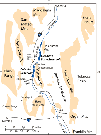
Elephant Butte Lake State Park is located approximately 5 miles north of the town of Truth or Consequences. Elephant Butte Reservoir is on the Rio Grande in south-central New Mexico east of Interstate 25 between Socorro and Las Cruces (Figure 1).
Facilities at Elephant Butte Lake State Park
Camping, picnicking, and boating facilities are available at this state park. Elephant Butte Lake State Park is the largest and most popular state park in New Mexico.
Introduction
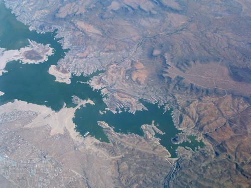
The 301-feet high and 1,674-feet long concrete dam across the Rio Grande that created Elephant Butte Reservoir is the largest dam in the state of New Mexico (Figures 2 and 3). Elephant Butte Reservoir was the largest man-made reservoir in the world when the dam was completed in 1916. Elephant Butte Dam can now store 2,065,010 acre-feet of water (An acre foot is equal to 325,829 gallons.), less than its designed capacity of 2,634,000 acre-ft because of sedimentation over the years. The dam is considered a National Historic Civil Engineering Landmark, primarily because the construction of this dam marked the first civil engineering project designed for international distribution of water. In addition, the dam is set into steeply dipping and highly fractured Cretaceous rocks, which do not serve as an ideal foundation for a dam. Clever engineering and a large amount of grout were need to stabilize the footing for the dam (Lozinsky et al., 1986, p. 26).

Caballo Dam, located approximately 22 miles downstream of Elephant Butte Dam, was completed in 1938 to control water releases from Elephant Butte Reservoir. Both Caballo and Elephant Butte Reservoirs are integral parts of the water storage system along the Rio Grande and its tributaries needed to deliver a relatively predictable water supply to southern New Mexico, West Texas, and Mexico.
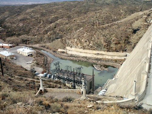
A 24.3 megawatt power plant (Figure 4), originally designed to provide electricity year-around, was added to Elephant Butte Dam in 1940 (Mueller, 1986). The facility at Elephant Butte Dam is the second largest hydroelectric system in New Mexico. Water released during power generation at Elephant Butte Dam is stored downstream in Caballo Reservoir. Elephant Butte Dam now generates electricity primarily during the irrigation season (mid-March to mid-October). Any water released from Elephant Butte Dam in the winter for power generation is stored at Caballo Dam for irrigation use in the summer.
Regional Geologic Setting
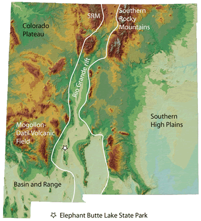
Elephant Butte Lake State Park is in the Rio Grande rift, a northerly-trending continental rift that extends from northern Colorado to northern Mexico (Figure 5). The park is in a portion of New Mexico that has been affected by compression, regional volcanism, and extension during the last 70 million years (Lozinsky et al., 1995; Seager and Mack, 2003). First, Laramide compression associated with a subduction zone along the west coast of North America formed west-northwest to north-south trending basement uplifts bounded by high-angle reverse faults and low-angle thrust faults (Nelson, 1986; Seager and Mack, 2003, Harrison and Cather, 2004). This compressional phase occurred mainly in during Paleocene to early Eocene time (~55 to 45 million years ago), although there is evidence for deformation as early as late Cretaceous and as late as late Eocene. Following Laramide deformation, regional latest Eocene to Oligocene (36 to 27 million years ago) volcanism from the Mogollon-Datil volcanic field (Figure 5) and other volcanic centers blanketed large portions of southern New Mexico with layers of ash-flow tuff and basalt flows. The distribution of the tuff indicates that topographic relief during middle Oligocene time was not as large as it is today. Volcanism was followed by, and was in part coeval with, extension starting about 36 million years ago, leading to the development of the Rio Grande rift.
Geologic History
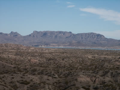
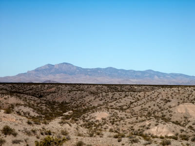
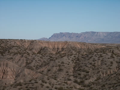
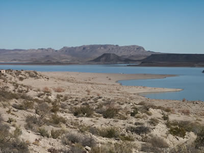
Several mountain ranges can be seen from Elephant Butte Lake State Park. The most prominent features are the Fra Cristobal Mountains to the east of the lake (Figure 6) and the northern Caballo Mountains to the south. The San Mateo Mountains dominate the skyline to the northwest (Figure 7) and the Cuchillo Mountains and Black Range are visible to the west. Four episodes of mountain building, several major cycles of the rise and fall of warm tropical seas, and a remnants of young volcanic eruptions are preserved in the rocks around Elephant Butte Lake. Most of the land outside of the state park around Elephant Butte Lake is private land; please obtain permission before entering private property.
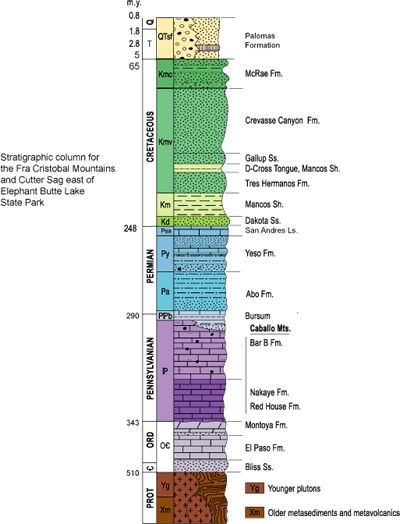
The following geologic history is modified from Lozinsky et al. (1995).
Proterozoic
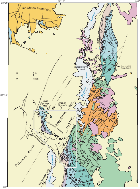
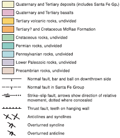
The oldest exposed rocks in the Elephant Butte area are located in scattered outcrops on the west side of the Fra Cristobal Mountains and include chlorite schist, amphibolite, and metamorphosed intermediate composition plutonic rocks that are more than 1.6 billion years old (Nelson, 1986). In Proterozoic time, these rocks were originally shale, basalt, and diorite. The rocks were then deeply buried and heated in the roots of a northeast-trending mountain range that started forming ~1.6 billion years ago. The combined effects of high pressures and temperatures eventually changed the shale and basalt into schist and amphibolite, respectively. Later, while still deeply buried, the metamorphic rocks were intruded by granitic magma about 1.4 billion years ago. Granitic rocks are the most common Proterozoic rock on the northwest side of the Fra Cristobal range (Figure 8). These rocks are gneissic (foliated) in places, indicating mild deformation at about 1.4 billion years ago (Nelson, 1986). Subsequent uplift and erosion brought these ancient rocks toward the Earth's surface where they weathered down to form a relatively flat platform by about 510 million years ago, when the Cambrian Bliss Sandstone was deposited on the old rocks. No record of the geologic events that may have occurred between 1400 and 510 (a gap of 890 million years!) is preserved in this area.
Early to Middle Paleozoic
A shallow ocean covered the Elephant Butte region starting about 510 million years ago. The Late Cambrian to Early Ordovician beach and nearshore deposits of the Bliss Sandstone were laid down on the Proterozoic rocks. The Bliss Sandstone forms a distinctive dark band that can be seen at low elevation on the west side of the Fra Cristobal Mountains. Shallow marine limestone and dolomite (El Paso Formation, Montoya Group, Figure 9) was subsequently deposited on top of the Bliss Sandstone during Early Ordovician to Silurian time. These carbonates form gray cliffs on the west side of the Fra Cristobal. During early to middle Paleozoic time, southern New Mexico was located just south of the equator. Shallow seas advanced and retreated across the area several times between 510 and 340 million years ago, depositing limestone, dolomite, shale and sandstone, until the second mountain building event, Ancestral Rockies deformation, began.
Many of the rock units exposed in the Caballo Mountains to the south of Elephant Butte State Park, including the upper part of the Ordovician Montoya Formation, the Silurian Fusselman Dolomite, the Devonian Percha Shale, and the Mississippian Lake Valley Formation, are not preserved in the Fra Cristobal Mountains. In the Fra Cristobal Mountains, the basal limestone of the Pennsylvanian Magdalena Group, the Red House Formation (Figure 9), rests on the middle part of the Montoya Group in the southern part of the range and on Proterozoic basement in the northern part of the range (Nelson, 1986; Figure 8)). Much of the Early to Middle Paleozoic section is missing in the Fra Cristobal Mountains because (1) these rock units generally thin slightly toward the north, and (2) the rock units are erosionally beveled beneath the Devonian and Pennsylvanian units due to broad-scale gentle regional tilting toward the south (Kelley and Silver, 1952; Seager and Mack, 2003).
Late Paleozoic
Ancestral Rocky Mountain development across the southwestern United States is characterized by north- and northwest-trending uplifts separated by intervening basins that are filled with both marine sediments and sediments shed from the adjacent uplifts. The Fra Cristobal and Caballo Mountains were located on the northwestern margin of one of the basins, the Orogrande Basin. Rocks older than early Mississippian in age (>340 million years old) in the Caballo Mountains to the south of Elephant Butte and in the Fra Cristobal Mountains to the east of Elephant Butte were gently tilted toward the southeast and eroded prior to deposition of early Pennsylvanian sediments about 312 million years ago. In the early stages of this tectonic episode, shallow seas persisted in the Elephant Butte region until ~290 million years ago, when sea level dropped and rivers started to flow southward across the area (Abo Formation, Figure 9). Windblown sand dune deposits marked a significant drying trend in New Mexico starting ~270 to 280 million years ago (basal Yeso Formation, Figure 9). The margin of the ocean returned late in Permian time and moved back and forth across the area, depositing limestone, dolomite, gypsum, and sandstone (upper Yeso Formation, Glorieta Sandstone, and San Andres Limestone, Figure 9).
Mesozoic to Early Cenozoic
No deposition occurred in the Elephant Butte region during most of Mesozoic time because southwestern New Mexico, including the area of interest, was on the northeastern flank of a west-northwest-trending rift that was active into Middle Cretaceous time. Consequently, no Triassic, Jurassic, or Early Cretaceous rocks are present here. Upper Cretaceous rocks lapped onto and buried the rift shoulder. The Upper Cretaceous rocks preserve a history of the oscillating landward and seaward migration of the shoreline of the Western Interior Seaway across this area about 95 to 80 million years ago. Following retreat of the sea, the Caballo Mountains were apparently covered with andesitic lavas from a stratovolcano located to the west of the range that has since been buried beneath the Rio Grande rift. The andesitic debris was eroded from the Caballo Mountains and deposited as conglomerates in the latest Cretaceous McCrae Formation, which crops out on the east side of the range (Figure 8 and 9). This interesting unit also contains siliceous tuffs, fossil leaves, petrified wood, and dinosaur bones. The distribution of the McCrae Formation in the Caballo Mountains and the Fra Cristobal Mountains records the beginning of the third mountain building event in the Elephant Butte area, compressional Laramide deformation. Laramide deformation reached its peak during Eocene time, forming a northwest-trending uplift in the southern Caballo Mountains (Seager and Mack, 2003), a north-south trending uplift in the Fra Cristobal Mountains and a basin between the southern Caballo Mountains and the Fra Cristobal Mountains (Cutter Sag, Figure 8).
The Laramide structures in the Fra Cristobal Mountains are impressive and include high angle, Proterozoic-basement-involved reverse faults and overturned folds in the overlying Paleozoic sedimentary cover, and low-angle, east-directed thrust faults in the Permian Yeso Formation in the southern part of the range (Nelson, 1986; Chapin and Nelson, 1986; Nelson and Hunter, 1986). In addition, the major range-bounding fault on the west side of the Fra Cristobal Mountains, the Hot Spring-Walnut Canyon fault, may have accommodated approximately 16 miles of right-lateral strike-slip motion during Laramide deformation (Harrison and Cather, 2004).
Middle to Late Cenozoic
Latest Eocene time, ~36 million years ago, marked the beginning of extension and regional volcanism, with volcanic rocks traveling long distances from source to point of deposition across a landscape much more subdued than we see today. The San Mateo Mountains to the northwest and the Black Range to the west of Elephant Butte Lake contain the remnants of volcanoes and calderas that formed during this time (Lozinsky et al., 1995).
Near the end of Oligocene time, about 25 million years ago, extension changed the landscape, leading to the formation of deep basins (Engle and Palomas Basins, Figure 1) and high mountains (Fra Cristobal and Caballo Mountains). These basins, part of the Rio Grande rift, were internally drained; in other words, water flowing into the basin did not flow out. The through-flowing Rio Grande had not yet developed in southern New Mexico. Water coming off the mountains ponded in playa lakes, shallow intermittent lakes that generally form only after rainstorms or spring runoff. The development of the Rio Grande rift uplifts and basins culminated in the middle part of the Miocene, about 15 to 16 million years ago.
An ancestral Rio Grande flowed through the Engle and Palomas Basins by about 5 million years ago (Pliocene). The ancestral Rio Grande, which was wider and sandier than the river today, flowed from northern New Mexico to Mexico, ending in a large playa lake near El Paso, Texas. The river did not flow to the Gulf of Mexico like it does today. These ancestral river deposits, as well as sediments washing off of the surrounding mountains (alluvial-fan deposits), and fine-grained playa lake sediments are called the Palomas Formation (Figure 10). Mammoth, camel, and horse fossils have been found in the Palomas Formation. While the Palomas Formation was being deposited, starting about 2.9 million years ago (Bachman and Mehnert, 1978), basaltic volcanoes were erupting on the east side of Elephant Butte Lake (Figure 11), particularly along the Hot Spring fault system, which acted as a conduit for magma. Cinder cones and maar craters are common volcanic features that can be seen on the east side of Elephant Butte Reservoir. Maars are broad, low-relief volcanic craters formed by shallow explosive eruptions that are usually caused by the heating and boiling of groundwater when magma invades the groundwater table. The maars at Elephant Butte are usually associated with ancestral Rio Grande deposits. Some of the younger basalt flows contain pieces of the lower crust and upper mantle (xenoliths) that offer geologists a rare opportunity to study blocks of rock derived from depths of 18 to 26 miles (29 to 42 km) below the Earth's surface (Warren et al., 1979). About 1 million years ago, the Rio Grande finally connected with the Gulf of Mexico, which triggered incision of the Rio Grande into the Palomas Formation.
References
- Bachman, G.O., and Mehnert, 1978, New K-Ar dates and the late Pliocene to Holocene geomorphic history of the central Rio Grande region, Geological Society of America Bulletin, v. 89, p. 283-292.
- Chapin, M.A., and Nelson, E.P., 1986, Laramide basement-involved deformation in the Fra Cristobal range, south central New Mexico: New Mexico Geological Society Guidebook 37, p. 107-114.
- Harrison, R.W., and Cather, S.M., 2004, The Hot Springs fault system of south-central New Mexico - evidence for the northward translation of the Colorado Plateau during the Laramide orogeny: New Mexico Bureau of Geology and Mineral Resources Bulletin 160, p. 161-179.
- Kelley, V.C., and Silver, C. , 1952, Geology of the Caballo Mountains: University of New Mexico Publications in Geology Number 4, The University of New Mexico Press, Albuquerque, New Mexico, 286 pp.
- Lozinsky, R.P., Harrison, R.W., and Lekson, S.H., 1995, Elephant Butte-eastern Black Range region: Journeys from desert lakes to mountain ghost towns: New Mexico Bureau of Mines and Mineral Resources Scenic Trips to the Geologic Past 16, 169 pp.
- Lozinsky, R.P., Osburn, G.R., Harrison, R.H., 1986, Second-day road log, from Truth or Consequences to Fra Cristobal Range via Elephant Butte dam, northern Caballo Mountains, Cutter Sag, and Jornada del Muerto, Segment A, from Truth or Consequences to Deep Well assembly point: New Mexico Geological Society Guidebook 37, p. 22-28.
- Mueller, J.E., 1986, History of Elephant Butte Dam and Reservoir: New Mexico Geological Society, Guidebook 37, p. 58-59.
- Nelson, E.P., 1986, Geology of the Fra Cristobal range, south-central, New Mexico: New Mexico Geological Society Guidebook 37, p. 83-92.
- Nelson, E.P., and Hunter, J.C., 1986, Laramide thin-skinned deformation in Permian rocks, Fra Cristobal range, south-central New Mexico: New Mexico Geological Society Guidebook 37, p. 115-122.
- Seager, W.R., and Mack, G.H., 2003, Geology of the Caballo Mountains, New Mexico: New Mexico Bureau of Geology and Mineral Resources Memoir 49, 135 pp.
- Warren, R.G., Kudo, A.M., and Keil, K., 1979, Geochemistry of lithic and single-crystal inclusions in basalt and a characterization of the upper mantle-lower crust in the Engle Basin, Rio Grande rift, New Mexico, in Riecker, R.E., ed., Rio Grande rift: Tectonics and magmatism: American Geophysical Union, Washington, D.C., p. 393-415.
- Wilks, M.E., compiler, 2005, New Mexico Geologic Highway Map: New Mexico Geological Society and New Mexico Bureau of Geology and Mineral Resources, scale1:1,000,000.


