


Fenton Lake State Park
We are a research and service division of:
Location
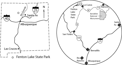
Fenton Lake State Park is located in the western Jemez Mountains and can be easily accessed from Albuquerque via U.S. Highway 550 at Bernalillo (Figure 1). Drive northwest on Highway 550 approximately 23 miles from the intersection of I-25 with Highway 550 in Bernalillo to San Ysidro. Turn north (right) off of Highway 550 at San Ysidro onto New Mexico State Road 4 and drive about 26 miles to La Cueva.. Turn west (left) onto New Mexico State Road 126 at the village of La Cueva and drive 4.9 miles along the winding highway to the top of Fenton Hill, then continue an additional 4.7 miles to Fenton Lake (total mileage from La Cueva = 9.6 miles). Fenton Lake can also be accessed from Los Alamos via New Mexico State Road 4.
Geology Within the Park
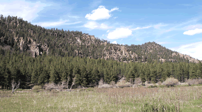
Fenton Lake State Park is on the west side of the Valles and Toledo calderas, large collapse features that formed during voluminous volcanic eruptions 1.6 and 1.25 million years ago. The landscape around Fenton Lake is characterized by broad, grass-covered valley bottoms that lie between dissected orange-brown to white mesas that are bound by imposing cliffs. The cliffs are formed by the 1.6 to 1.25 million year old outflow sheets of Bandelier Tuff that erupted from the calderas. The south-flowing Rio Cebolla (Spanish word for onion), which feeds Fenton Lake, cut one of the broad valleys after 1.25 million years ago.
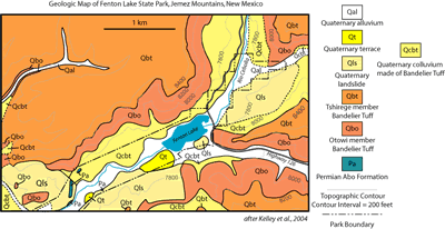
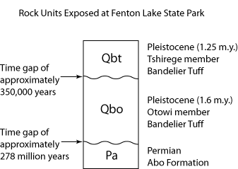
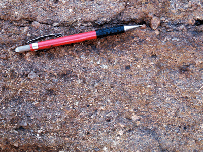
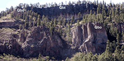
Three main rock units are exposed within the boundaries of the state park (Figure 2). The oldest unit is the Permian Abo Formation, a red to white, arkosic sandstone interbedded with red siltstone deposited by an ancient river approximately 280 million years ago. This sandstone contains angular pebbles of quartz, potassium feldspar, and granite (Figure 3), indicating that the sediment has not traveled far from the granitic source from which it was eroded. These pebbly sandstones were derived in part from the Peñasco uplift to the west of Fenton Lake, which roughly coincides with the present position of the Sierra Nacimiento. The Peñasco uplift formed during the Ancestral Rocky Mountain building event that occurred during late Pennsylvanian to early Permian time (Woodward, 1987). These Permian rocks, which are present at low elevation along both sides of the Rio Cebolla, can be seen along the main road along the west side of the lake near the south end of the park (Figure 2).
The Permian redbeds are overlain by the 1.6 million year old Otowi (Tewa word for “gap where the water sinks”; Martin, 1998) Member of the Bandelier Tuff (Figures 2 and 4). Mesozoic rocks are preserved on top of the Abo Formation elsewhere in the Jemez Mountains. These Mesozoic rocks, which represent hundreds of millions of years of Earth’s history, were eroded away prior to the deposition of the tuff in this particular area (Figure 2). This erosion probably occurred during the Laramide mountain building event that affected this part of New Mexico about 55 million years ago, forming the Sierra Nacimiento to the west (Woodward, 1987).
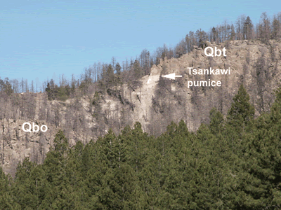
The Otowi Member tuff is made of pumice, ash, crystals of quartz and sanidine, and dark-colored (black to brown) rock fragments that were violently erupted from the Toledo caldera. The Otowi Member at Fenton Lake is unusually thick compared to other parts of the Jemez Mountains and it exhibits welding, which again is unusual for this unit. The Tshirege (pronounced shur-gay, Tewa word for “bird place”; Martin, 1998) Member of the Bandelier Tuff overlies the Otowi Member. The Tshirege Member is similar in overall composition, but contains fewer rock fragments. In this area, the two tuffs are separated by about 1-2 m (3-6 ft) of tephra belonging to the Tsankawi (Tewa word for “gap of the sharp, round cactus”, Martin, 1998) Pumice Bed, which was deposited during the beginning phase of the younger Tshirege eruption (Figure 5). The Tshirege Member fills in a rugged paleotopography that developed on the Otowi Member during the 350,000 years between eruptions (Figure 4).
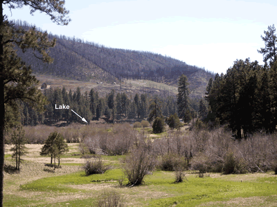
These rocks are overlain by much younger colluvium and landslide deposits, as well as old terrace deposits and modern alluvium deposited by the Rio Cebolla (Figure 1). Debris flows resulting from erosion of the hillsides denuded during the August, 2002 forest fire (Figure 6) near Fenton Lake periodically are deposited on Highway 126, temporarily blocking access to the lake. Shortly after the fire, some of these debris flows were deposited in the lake.
References
Kelley, S.A., G.R. Osburn, C.A. Ferguson, and M. Osburn, 2004, Geology of the Seven Springs 7.5’ quadrangle, Sandoval and Rio Arriba Counties, New Mexico, New Mexico Bureau of Geology and Mineral Resources OF-GM 88, 1:24,000 scale.
Martin, C., 1998, Los Alamos place names: Los Alamos Historical Society, Los Alamos, New Mexico, 126 pp.
Woodward, L.A., 1987, Geology and mineral resources of Sierra Nacimiento and vicinity, New Mexico: New Mexico Bureau of Mines and Mineral Resources, Memoir 42, 84 p.