


Oliver Lee Memorial State Park
We are a research and service division of:
modified from McLemore, V.T., 1996, Oliver Lee Memorial State Park, New Mexico Geology, v. 18, no. 1, p. 14-17.
Introduction
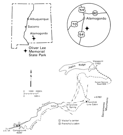
Oliver Lee Memorial State Park, at the mouth of Dog Canyon on the western escarpment of the Sacramento Mountains (Fig. 1), opened in 1980, but the area has attracted visitors for several thousands of years. The 180-acre state park has a flowing stream and forms an oasis on the edge of the harsh desert of the Tularosa (Spanish, "reddish willows") Valley. The park is named for Oliver Lee (1865-1941), a prominent rancher and state legislator who settled near the mouth of Dog Canyon in the late 1880s. Lee was active in developing water-control projects in the area. Oliver Lee's ranch is one of the many exhibits at the state park. The Visitor's Center houses displays of the geologic and cultural history of the canyon area. Approximately 30,000 people enjoy camping, hiking, and picnicking in the park each year. An interpretative trail along lower Dog Canyon allows visitors a glimpse of vegetation and wildlife in the oasis as well as several cultural sites. The Dog Canyon Trail starts at an elevation of about 4,500 ft in the state park and climbs the steep escarpment of the Sacramento Mountains to the Eyebrow Trail to Joplin Ridge at an elevation of 7,753 ft, for a total one-way distance of about six miles (Fig. 1).
Geology
Dog Canyon is one of several rugged box canyons that drain the western Sacramento Mountains (Fig. 2). The canyon floor is at an elevation of 4,500 ft and rises to 9,700 ft, forming the highest point on the Sacramento escarpment.
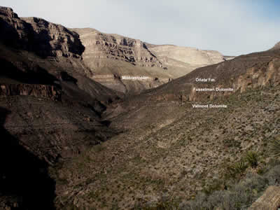
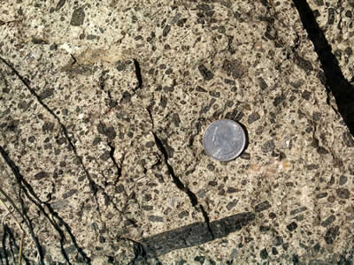
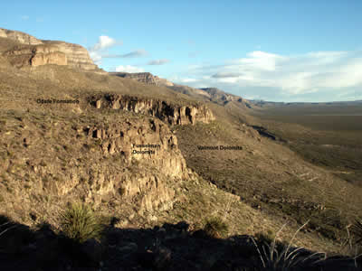
In the canyon and along the escarpment of the Sacramento Mountains, a section of sedimentary rocks ranging in age from Lower Ordovician to middle Permian is exposed (Figs. 3 and 4; Pray, 1961; Kottlowski, 1981; Austin et al.,1992). The oldest unit exposed at the bottom of the mountains is the El Paso Formation (Ordovician), which consists of approximately 430 ft of gray dolomite, dolomites quartz sandstone, and cherry nodules and lenses that were deposited near the shoreline of a shallow sea about 480 million years ago. Erosion occurred as the seas withdrew for a short time. Then the seas returned to deposit the 350 ft of dolomitic sandstones and dolomites of the Montoya Formation (Ordovician) that overlies the El Paso Formation. The Montoya Formation is divided into three units: the thin, basal Cable Canyon Sandstone, Upham Dolomite, and Aleman Dolomite (the youngest unit). The Valmont Dolomite (Ordovician), Fusselman Dolomite (Silurian), and Oñate and Sly Gap Formations (Devonian) overlie the Montoya Formation. The Valmont Dolomite consists of approximately 150 ft of light-gray, fine-grained dolomite with locally abundant chert nodules and thin dolomitic shale lenses; it is correlative with the Cutter Formation elsewhere in southeastern New Mexico (Pray, 1961; Austin et al., 1992). The Fusselman Dolomite, less than 85 ft thick, consists of a resistant, brownishgray ledge of finely crystalline dolomite with abundant chert layers and nodules. Rare fossils are found in the dolomite. It forms the upper ledge approximately 500 ft above the Visitor's Center. The seas began to withdraw once again as 60-100 ft of dolomitic siltstone, dolomite, quartz sandstone, limestone, and shale forming the Oñate and Sly Gap Formations were deposited on a shallow-marine floor and in local basins or lagoons. Two Tertiary camptonite porphyry sills have intruded the Devonian sedimentary rocks (Figs. 3, 4, and 5) and crop out along the Dog Canyon Trail.
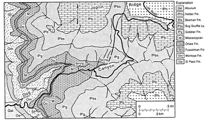
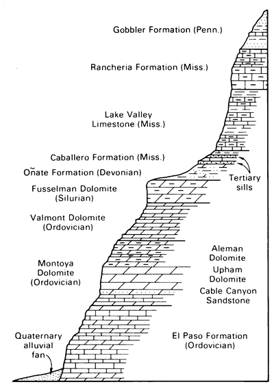
Seas once again migrated over the area about 345-320 million years ago as Mississippian rocks of the Caballero Formation, Lake Valley Limestone, and Rancheria Formation were deposited on top of the Ordovician-Devonian rocks. The Caballero Formation consists of 60 ft of interbedded gray limestone and calcareous shale. The Lake Valley Limestone is as thick as 400 ft and consists of crinoidal limestones and minor thin siltstones and shales deposited on top of a shallow-marine shelf. On the north slopes of Dog Canyon two large biohermal mounds crop out in the Lake Valley Limestone (Kottlowski, 1981). These bioherms are thick mounds of fossil crinoids, bryozoans, and dense limestone that formed near the edge of the continental shelf (Bowsher, 1986). Post-biohermal beds pinch out against these bioherms. The Rancheria Formation consists of thin-bedded argillaceous and silty limestones, approximately 250 ft thick.
The Gobbler Formation (Pennsylvanian) forms the uppermost slopes of the Sacramento escarpment visible from the Visitor's Center at Dog Canyon and is more than 1,200 ft thick. It consists of shallow-marine sandstones, shales, and limestones of Atokan age deposited about 308-312 million years ago (Algeo et al., 1991). The uppermost sheer cliffs visible from the Visitor's Center belong to the Bug Scuffle Limestone Member of the Gobbler Formation. Younger Pennsylvanian and Permian sedimentary rocks overlie the Gobbler Formation but are not visible from the state park. The uppermost Eyebrow Trail crosses these rocks.
Oliver Lee Memorial State Park lies on the edge of the Tularosa Valley, a closed basin of the Rio Grande rift, which covers an area of approximately 6,500 mi2. Basin and Range faulting began about 35 million years ago and resulted in the uplift of the bordering mountains, the San Andres, Organ, and Franklin Mountains to the west and the Sacramento Mountains and Sierra Blanca to the east. The basin fill is comprised of interbedded sand, silt, clay, and evaporites forming the middle Miocene to middle Pleistocene Santa Fe Group, about 35 to 1 million years old (Lozinsky and Bauer, 1991). Material shed from the steep escarpment (Fig. 6) during intense rainstorms and rapid snowmelt deepen and cut into the canyons, such as Dog Canyon, and form the Quaternary alluvial-fan deposits that form aprons along the foothills of the mountains.
During late Pleistocene time (1 million-10,000 years ago), a large, shallow lake, named Lake Otero, occupied much of the basin; the state park lies on the eastern shoreline (Herrick, 1904; Blair et al., 1990). Lake Otero was formed from melt water of glaciers in Sierra Blanca and began to dry up about 20,000 years ago as the climate became warmer and drier. Remnants of Lake Otero are present today as the gypsum dunes forming White Sands National Monument and as modern-day Lake Lucero and Alkali Flat playa.
The springs feeding Dog Canyon come from rain and snowmelt that make a way through cracks, fractures, and bedding planes in the mountains and come out along beds of the Montoya Formation and at Fairchild Canyon from Mississippian limestones. White to gray travertine coats the canyon walls in places and was formed by dissolution of the limestones and dolomites and precipitation of calcium carbonate from the flowing water.
On the steep north side of Dog Canyon, above the picnic area in the canyon bottom, a shallow shaft, 15 ft deep, cuts into the Montoya and upper El Paso rocks. The shaft was driven along an altered fracture zone in hopes of finding hidden mineral deposits. Yellowish-brown material forms a talus from the workings. Only calcite and iron oxides are found (Kottlowski, 1981).
References
- Algeo, T. J., Wilson, J. L., and Lohmann, K. C., 1991, Eustatic and tectonic controls on cyclic sediment accumulation patterns in Lower-Middle Pennsylvanian strata of the Orogrande Basin, New Mexico; in Barker, J. M., Kues, B. S, Austin, G. S., and Lucas, S. G. (eds.), Geology of the Sierra Blanca, Sacramento, and Capitan Ranges, New Mexico: New Mexico Geological Society, Guidebook 42, pp. 203-212.
- Austin, G. S., Barker, J. M., Bauer, P. W., Bowsher, A. L., Colpitts, R. M., Jr., Lucas, S.G., Cather, S. M., Hawley, J. W., Kottlowski, F. E., Kues, B. S., McLemore, V. T., Smith, C. T., and Toomey, D. F., 1991, Stratigraphic nomeclature chart; in Barker, J. M., Kues, B. S, Austin, G. S., and Lucas, S. G. (eds.), Geology of the Sierra Blanca, Sacramento, and Capitan Ranges, New Mexico: New Mexico Geological Society, Guidebook 42, back cover.
- Blair, T. C., Clark, J. S., and Wells, S. G., 1990, Quaternary continental stratigraphy, landscape evolution, and application to archeology: Jarilla piedmont and Tularosa graben floor, White Sands Missile Range, New Mexico: Geological Society of America, Bulletin, v. 102, pp. 749-759.
- Bowsher, A. L., 1986, Late Paleozoic reef complexes of the northern Sacramento Mountains, New Mexico; in Ahlen, J. L., Hanson, M. E., and Zidek, J. (eds.), Southwest section of AAPG Transactions and Guidebook of 1986 convention, Ruidoso, New Mexico: New Mexico Bureau of Mines and Mineral Resources, pp. 49-72.
- Clemons, R. E., 1996, A trip through space and time-Las Cruces and Cloudcroft: New Mexico Bureau of Mines and Mineral Resources, Scenic Trip 15, 194 pp.
- Herrick, C. L., 1904, Lake Otero, an ancient salt lake in southern New Mexico: American Geologist, v. 34, pp. 174-189.
- Kottlowski, F. E., 1981, Oliver Lee Memorial State Park: New Mexico Geology, v. 3, pp. 59-60,63.
- Lozinsky, R. P, and Bauer, P. W., 1991, Structure and basin-fill units of the Tularosa Basin; in Barker, J. M., Kues, B. S, Austin, G. S., and Lucas, S. G. (eds.), Geology of the Sierra Blanca, Sacramento, and Capitan Ranges, New Mexico: New Mexico Geological Society, Guidebook 42, pp. 7-9.
- McLemore, V. T., 1991, Oliver Lee Memorial State Park; in Barker, J. M., Kues, B. S, Austin, G. S., and Lucas, S. G. (eds.), Geology of the Sierra Blanca, Sacramento, and Capitan Ranges, New Mexico: New Mexico Geological Society, Guidebook 42, pp. 12-13.
- Pray, L. C., 1961, Geology of the Sacramento Mountains escarpment, Otero County, New Mexico: New Mexico Bureau of Mines and Mineral Resources, Bulletin 35, 144 pp.