
Gila Cliff Dwellings National Monument
Introduction
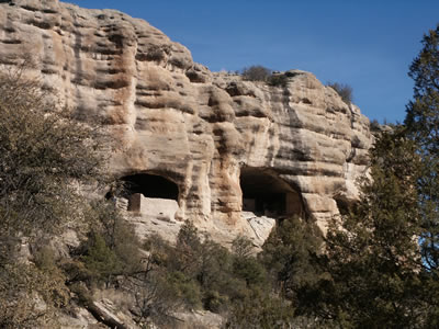
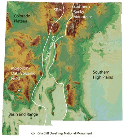
Gila Cliff Dwellings National Monument (Figure 1) is in the Mogollon Mountains approximately 44 miles north of Silver City, New Mexico. Gila Cliff Dwellings National Monument was established in 1907 and is one of the nation’s oldest monuments. The monument lies within the Mogollon-Datil volcanic field; volcanic eruptions from this field covered 40,000 km2 of southwestern New Mexico and southeastern Arizona with lava and ash flow tuffs 40 to 24 million years ago (Chapin et al., 2004a).
The Mogollon-Datil volcanic field (Figure 2) lies on the southeastern margin of the relatively undeformed Colorado Plateau. The volcanic field is bounded on the south by the Basin and Range province, a region of middle Miocene extension, and is broken on the east side by faulting associated with the Rio Grande rift, a northerly-trending zone of more profound crustal extension compared to the Basin and Range.
Regional Geologic History
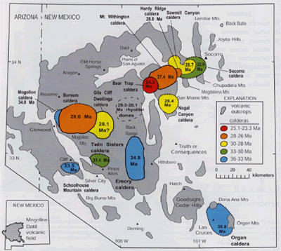
Volcanism began in this area about 40 million years ago, peaked 36 to 24 million years ago, and has been relatively minor since 24 million years ago (McIntosh et al., 1991; Chapin et al., 2004a and b). Early on, between 40 and 36 million years ago, andesite lavas were erupted from widely spaced shield and stratovolcanoes. Aprons of sediments derived from the erosion of the volcanoes filled the low spots between the volcanic edifices. Starting about 36 million years ago, explosive rhyolitic caldera eruptions occurred, leaving large circular depressions across the landscape. Calderas form when large volumes of pumice, ash, and fragmented rock are rapidly erupted. The eruption of so much material from a subsurface magma chamber so quickly (over a period of days to weeks) removes support from the chamber roof, causing collapse of the roof into the magma chamber. As a result, a depression or caldera that is hundreds of feet deep and tens of miles across is formed. Remnants of 13 calderas have been recognized in the Mogollon-Datil volcanic field, although more must be present (Figure 3; Chapin et al., 2004a). The type of rock that is deposited by such violent eruptions is called tuff, which is made of pumice, ash, crystals of quartz and sanidine, and rock fragments. At least 11 large eruptions occurred in the Mogollon-Datil volcanic field between 36.2 and 31.4 million years ago, releasing a total of about 3000 km3 of volcanic ash, tuff, and lava flows in 4.8 million years. Interestingly, volcanic activity waned between 31.5 and 29.0 million years ago. Vigorous volcanism returned 29.0 to 27.4 million years ago, resulting in ten large eruptions that released 6000 km3 of volcanic material in a mere 1.6 million years.
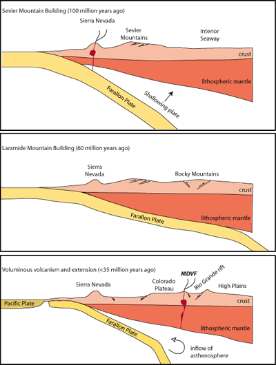
What triggered all this volcanic activity? The voluminous outpouring of lava and ash can be explained in terms of plate tectonics. According to one hypothesis (Atwater, 1970; Lipman et al., 1972; Elston, 1976), the story of the Mogollon-Datil volcanic field actually began nearly 100 million years ago and hundreds of miles to the west, when a plate, known as the Farallon Plate, was subducted eastward under the western edge of the North American Plate. This plate, which was between the Pacific and the North American plates, has largely been consumed by subduction during the last 100 million years; we now see only two small fragments of it on the ocean floor off the west coast today. Originally, the Farallon Plate was subducted beneath North America at a fairly steep angle, giving rise to the magmatism preserved in the roots of the Sierra Nevada in California and the coastal range batholiths of California and Baja California (Figure 4). Magmatism migrated eastward and arrived in southwestern New Mexico approximately 70 million years ago. This eastward migration is thought to have been caused by flattening of the subduction angle of the Farallon plate, initiated either by an increase in the rate of subduction or by subduction of a buoyant oceanic plateau. Between about 70 and 40 million years ago, the amount of magmatism dramatically decreased because the slab was subducting at such a shallow angle that little melting could occur; some magmatism did occur in southwestern New Mexico during this time (McMillan, 2004). A similar situation can be observed today off the west coast of South America (e.g., Allmendinger et al., 1997). Compression of the crust associated with low-angle subduction led to the formation of the Rocky Mountains.
Between 45 and 36 million years ago, the subduction of the Farallon Plate slowed and the angle of subduction started to increase. New Mexico was still under mild compression as the early andesites in the Mogollon-Datil volcanic field began to erupt (Cather, 1990). As the slab continued to roll back or sink down into the mantle, hot asthenosphere came in contact with lithospheric mantle that had been enriched by fluids during the subduction process. In addition, the crust began to extend. As a consequence, the conditions were right for abundant volcanism.
McIntosh and Bryan (2000) relate the waning of volcanism between 32 and 29 million years ago to the transition from compression and subduction-related volcanism to extension and mostly bimodal (rhyolite and basalt) volcanism. Tuffs that predate the hiatus were derived from subduction-related magmas enriched in fluids and gas, while the younger tuffs are from magmas that contain less fluids and gas (McIntosh and Bryan, 2000).
Geology of Cliff Dweller Canyon
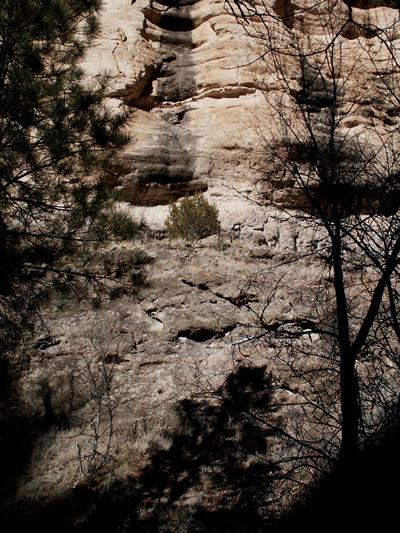
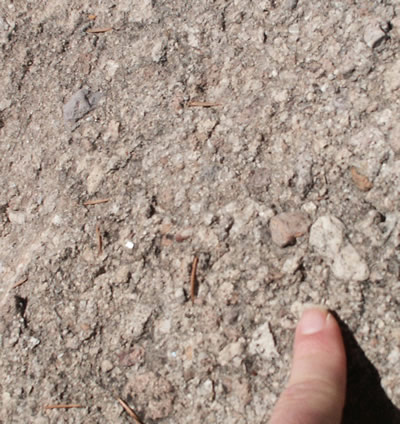
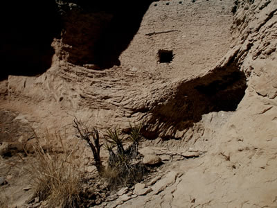
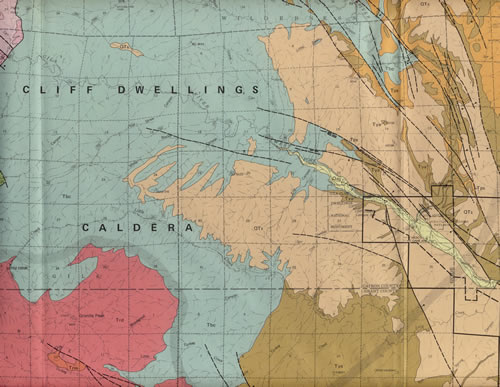
Two rock units can be observed along the hike up to the cliff dwellings (Figure 5) and a third unit is exposed in the parking lot. The oldest unit, which is exposed along the north side of the parking lot, is Bloodgood Canyon Tuff, which was erupted from the Gila Cliff Dwellings caldera (Figure 9) 28 million years ago. Gila Cliff Dwellings Nation Monument lies on the eastern margin of the caldera. The tuff is overlain by basaltic and andesitic lava flows at are estimated to be 25 to 26 million years old. The Gila Conglomerate, a sedimentary unit that contains pieces of older volcanic rocks, including the Bloodgood Canyon Tuff, caps the sequence (Figures 6 and 7). The cliff dwellings are built in shallow caves that formed at about the same stratigraphic level along weak (somewhat less cemented) zones within the Gila Conglomerate. Ratté (2000) speculates that the caves started to form about 500,000 years ago when Cliff Dweller Creek was flowing at the level of the caves. The creek carved alcoves into the conglomerate, particularly in places where the conglomerate is soft. Since that time, the creek has cut down 200 feet (65 m) to form the canyon that we see today. The alcoves, now stranded high and dry above the creek, continued to enlarge by roof collapse.
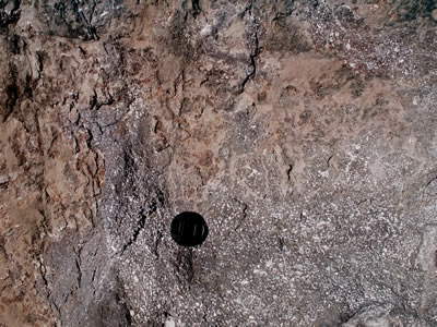
The Gila Conglomerate in the caves displays an unusual feature not typically seen in sedimentary rocks. Closely-spaced exfoliation fractures that cut across the bedding in the conglomerate are aligned roughly parallel the cliff face or the geometry of the cave openings (Figure 8). These exfoliation joints have contributed to the enlargement of the caves (Ratté, 2000). Exfoliation joints are commonly seen in granitic terrains and form during the unloading of deeply emplaced intrusive igneous rocks by erosion. Exfoliation joints in granites tend to parallel the topography, resulting in the formation of thick slabs of rock. The exfoliation joints in the conglomerate are smaller in scale, but are equally effective agents of mechanical erosion.
References
- Allmendinger, R. W., Jordan, T. E., Kay, S. M., and Isacks, B. L., 1997, The evolution of the Altiplano–Puna Plateau of the central Andes: Annual Reviews of Earth and Planetary Sciences, v. 25, pp. 139–174.
- Atwater, T., 1970, Implications of plate tectonics for the Cenozoic tectonic evolution of western North America: Geological Society of America Bulletin, v. 81, no. 12, pp. 3513–3536.
- Cather, S. M., 1990, Stress and volcanism in the northern Mogollon–Datil volcanic field, New Mexico—effects of the post-Laramide tectonic transition: Geological Society of America Bulletin, v. 102, no. 11, pp. 1447–1458.
- Chapin, C.E., McIntosh, W.C., and Chamberlin, R.M., 2004a, The Late Eocene—Oligocene peak of Cenozoic volcanism in southwestern New Mexico, in Mack, G.H., and Giles, K.A., The Geology of New Mexico, a Geologic History: New Mexico Geological Society Special Publication 11, 271-294
- Chapin, C.E., Wilks, M., and McIntosh, W.C., 2004b, Space-time patterns of Late Cretaceous to present magmatism in New Mexico—comparison with Andean volcanism and potential for future volcanism: New Mexico Bureau of Geology and Mineral Resources Bulletin 160, p. 13-40.
- Elston, W. E., 1976, Tectonic significance of mid-Tertiary volcanism in the Basin and Range province—a critical review with special reference to New Mexico; in Elston, W. E., and Northrop, S. A. (eds.), Cenozoic volcanism in southwestern New Mexico: New Mexico Geological Society, Special Publication 5, pp. 93–102.
- Humphreys, E., Hessler, E., Dueker, K., Farmer, C., Erslev, E., and Atwater, T., 2003, How Laramide-age hydration of North American lithosphere by the Farallon slab controlled subsequent activity in the western United States: International Geology Review, v. 45, p. 575–595.
- Lipman, P. W., Protska, J. J., and Christiansen, R. L., 1972, Cenozoic volcanism and plate tectonic evolution of the western United States, I, Early and middle Cenozoic: Royal Society of London, Philosophical Transactions, Series A, v. 271, no. 1213, pp. 217–248.
- McIntosh, W. C., and Bryan, C., 2000, Chronology and geochemistry of the Boot Heel volcanic field, New Mexico; in Lawton, T. F., McMillian, N. J, and McLemore, V. T. (eds.), Southwest passage— a trip through the Phanerozoic: New Mexico Geological Society, Guidebook 51, pp. 157–174.
- McIntosh, W.C., Kedzie, L.L., and Sutter, J.F., 1991, Paleomagnetism and 40Ar39Ar ages of ignimbrites, Mogollon-Datil volcanic field, southwestern New Mexico: New Mexico Bureau of Geology and Mineral Resources Bulletin 135, 79 pp.
- McMillan, N.J., 2004, Magmatic record of Laramide subduction and the transition to Tertiary extension: upper Cretaceous through Eocene igneous rocks of New Mexico, in Mack, G.H., and Giles, K.A., The Geology of New Mexico, a Geologic History: New Mexico Geological Society Special Publication 11, p. 249-270.
- Ratté, J.C., 2000, Origin and development of the caves at the Gila Cliff Dwellings National Monument, southwestern, New Mexico: New Mexico Geology, v. 22, p. 55.
- Ratté, J.C., and Gaskill, D.L, 1975, Reconnaissance geologic map of the Gila Wilderness Study Area, southwest New Mexico: U.S. Geological Survey Miscellaneous Investigation Series Map I–886, scale 1:62,500.


