
Introduction to the Geology of the Permian Reef Complex, Guadalupe and Delaware Mountains, New Mexico & West Texas
Outline:
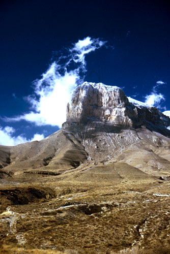
© Peter A. Scholle, 1999
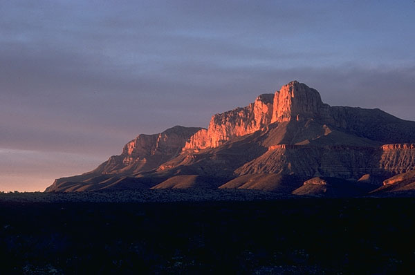
© Peter A. Scholle, 1999
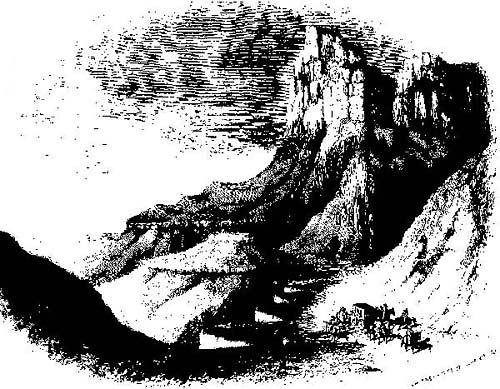
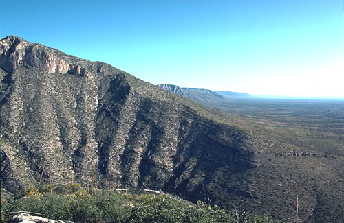
© Peter A. Scholle, 1999
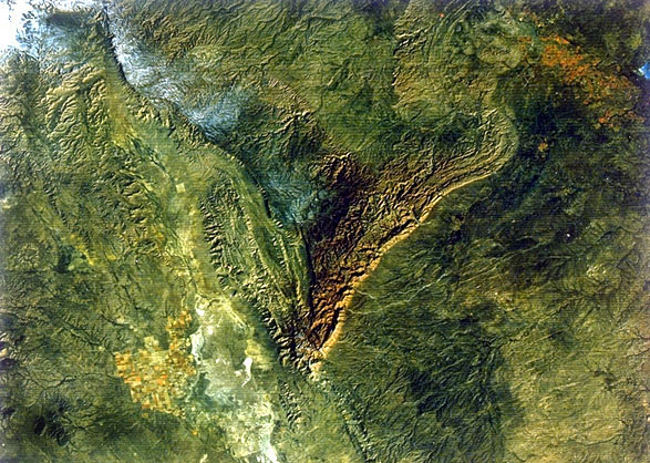
Overview
This site offers a virtual field trip to the classic Permian reef complex and other geologic features of the Guadalupe Mountains. It contains an introduction to the geology of the Permian reef complex (below) plus several roadlogs with diagrams and photographs, as well as an extensive bibliography in order to provide a balanced presentation for a geology student audience. Although the work is copyrighted, feel free to us any parts of it for teaching purposes as long as you acknowledge the source. To use portions for other purposes, please contact Peter Scholle.
General Setting
The Permian Basin region of New Mexico and west Texas provides an excellent opportunity to study the interrelationships of depositional facies, diagenetic alteration patterns, oil generation and migration, and ultimately, petroleum potential and production from carbonate reservoirs. The Guadalupe and Delaware Mountains, in particular, contain some of the finest outcrops of reef and reef-related rocks in the world. It is also a region of stark, yet often spectacular, beauty and of rich history, both for Native Americans and later arrivals.
The entire depositional spectrum from far-back-reef to deep basin can be observed in outcrops of the Guadalupe Mountains and adjacent areas, with little or no structural deformation and very slight vegetation or soil cover. The reef complex of this region is dissected by a series of deep canyons cut approximately at right angles to the regional facies strike. These canyons, especially McKittrick Canyon, provide exceptional cross-sectional views of the lateral and vertical relations of depositional environments through time.
Finally, the region is rather exceptional in that, at the end of Guadalupian time, the entire suite of facies was preserved (essentially pickled) by extremely rapid deposition of evaporites (gypsum/anhydrite, halite, sylvite, and more exotic salts). These Ochoan evaporites filled the Delaware basin remnants and even covered adjacent shelfal areas. Thus, original facies relations were preserved from extensive erosional modification, and late Tertiary uplift, coupled with dissolution of the very soluble evaporites, has led to resurrection of original (Permian) topography , greatly facilitating facies reconstruction.
In addition to the advantages provided by these outcrops, the Permian Basin has a wealth of subsurface data. More than 40,000 exploration wells and 200,000 development wells have been drilled in the Permian Basin region. All the outcrop facies of the Guadalupe, Delaware, and Glass Mountains are encountered in the subsurface Delaware basin, Northwest Shelf, Central Basin Platform, Midland basin, and to a lesser degree, the Marfa basin. Thus, the associations of oil and gas with specific depositional and diagenetic facies can be clearly established in this region.
Previous Studies
A number of classic studies have been completed on the "Permian reef complex" of New Mexico and Texas which have established an excellent stratigraphic and sedimentologic framework for the region. Three early studies (King, 1948; Adams and Frenzel, 1950; Newell et al., 1953), in particular, presented the overall outlines of our modern concept of reef-related depositional environments. Subsequent studies, including those of Dunham (1972), Esteban and Pray (1977), Harms (1974), Hayes (1964), Mazzullo and Cys (1977), Meissner (1972), Schmidt (1977), Tyrrell (1969), Sarg and Lehman (1986), Ward et al. (1986), and numerous University of Wisconsin graduate students under Lloyd Pray's direction (e.g., J. Babcock, 1977; Yurewicz, 1976, 1977; Sarg, 1981 and 1989; Crawford, 1981 and 1989; Rossen, 1985; Candelaria, 1982 and 1989; Franseen, 1985 and 1988; and others) have fleshed in the details of many of the depositional environments and have contributed to our understanding of the diagenetic history of the region. In recent years, stratigraphic studies have focused primarily on large-scale sequence stratigraphic interpretations (Kerans and Fitchen, 1995; Lindsay and Reed, 1992; Mutti and Simo, 1993; Osleger, 1998; Sarg, 1989; Tinker, 1998), bed-scale cyclicity (Borer and Harris, 1991; Gardner, 1991; Harris et al., 1993; Kerans and Nance, 1991; Lowenstein, 1988; Sonnenfeld, 1991), or chemostratigraphy (Colgan, 1990; Magaritz et al., 1983; Grossman, 1994; Scholle, 1995). Finally, studies of Holocene deposits in unusually arid modern settings have also contributed directly to our understanding of comparable deposits in the Permian (e.g., Kendall, 1969; Warren, 1983; Handford et al., 1984; Logan, 1987).
In spite of this, however, few areas have more unresolved geological controversies than the Permian reef complex. Every single one of the facies represented in the spectrum of basinal to far-back-reef settings has evoked a variety of opinions (discussed later) as to its origin or significance. Thus, although the overall environmental framework of facies is generally agreed upon, much work remains to be done on specific interpretations.
Structural History
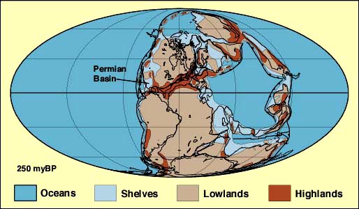
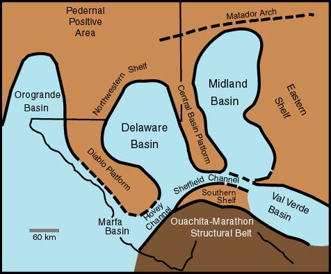
The Permian basin region was situated close to the western margin of Pangaea during Late Permian (Guadalupian to Ochoan or, in international teminology, Kazanian to Tatarian) time and lay about 10° north of the paleo-equator of that time (first figure below), although the latitudinal estimate varies depending on the plate reconstruction one uses (Smith et al., 1973; Scotese et al., 1979; Irving and Irving, 1982; Scotese and McKerrow, 1990; Scotese and Langford, 1995). The region was part of the southern flank of the North American craton, a zone of moderate subsidence and shelfal, mainly carbonate, sedimentation until Pennsylvanian time. During the late Paleozoic, the Permian basin region was subdivided into a series of smaller basins and platforms (second diagram below).
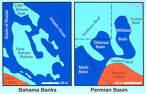
Some of these features formed well before the Permian; for example, there is some indication that the Central Basin Platform was already a positive topographic element during Early Mississippian time (Wuellner et al., 1986). However, full-scale initiation of the Delaware, Midland, Val Verde and Marfa basins (and associated shelfal areas) did not occur until the onset of the Pennsylvanian Ouachita-Marathon orogeny (Hills, 1984; Hills, 1985; King, 1948; Ross, 1979). This major continental collision event established a regional transpressional regime, generated a complex fore-deep trough in the Permian basin region, and caused the rejuvenation of older, north-south to northwest-southeast oriented basins and uplifts(first diagram below), including the Ancestral Rockies (Kluth and Coney, 1981; Ross, 1986; Goetz and Dickerson, 1985). The orogeny formed the underlying control for most Late Pennsylvanian to Permian sedimentation from Texas to Colorado and led to the eventual formation of a platform-basin geometry similar to that seen in the Bahamas today (Ball, 1967; Ball et al., 1969; see diagram). The major paleotopographic features of the region are bounded by complex sets of high-angle faults that generally formed along reactivated earlier Late Precambrian to Cambrian structural lineaments
(Hills, 1984; Oriel et al., 1967; Ross, 1986).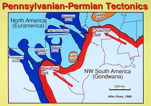
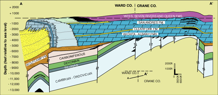
Such structures were further accentuated by differential sedimentation and regional subsidence during Permian time, resulting in the complex features shown in the cross-section of the Central Basin Platfrorm and adjacent areas (see diagram). In this scenario, original structural relief was significantly accentuated by higher rates of sedimentation of shallow water carbonate deposits on structural "highs" compared with lower rates on structural "lows." Thus, basins which may have been only a few tens of meters deep at the start of Permian time eventually had water depths in excess of 500 m (1,600 ft) by the close of Guadalupian time. These paleo-water-depths are reasonably well established because large-scale continuity of outcrop has allowed the physical measurement (after correction for compaction) of elevation differences between age-equivalent shelf and basin deposits.
Although these local variations in sedimentary facies and sedimentation
rates existed, the Permian basin was also subjected to broadly regional subsidence,
resulting in the accumulation of between 2,100 and 4,200 m (7,000 and 14,000
ft) of Permian clastic terrigenous, carbonate, and evaporite strata (McKee et al., 1967). Specifically, about 3.5 km (12,000 ft) of Permian strata have
been measured in outcrops from the Guadalupe Mountains, on the western side
of the Permian basin (King, 1948). In that
area, the early Late Permian (Guadalupian) section, the main focus of this field
trip, contains about 1 km (3,500 ft) of sediment and the overlying Ochoan sequence
is even thicker where it is preserved in the Delaware basin. Considering that
most current geologic time-scales accord approximately 10 million years or less
to the combined Guadalupian-Ochoan interval (Harland et al., 1990; Menning, 1995; Palmer,
1983), Permian average rates of basin subsidence and sedimentation were quite
high (>200 m/my).
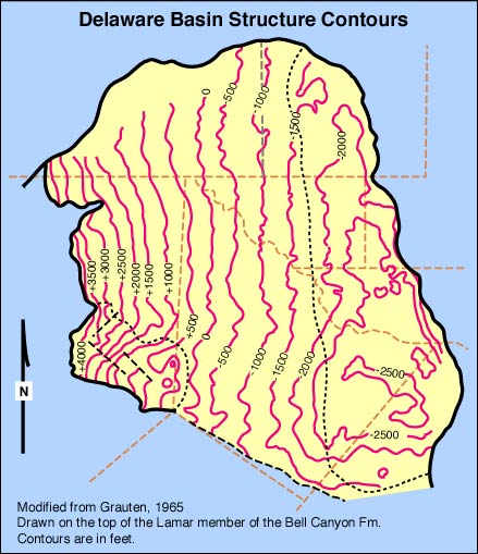
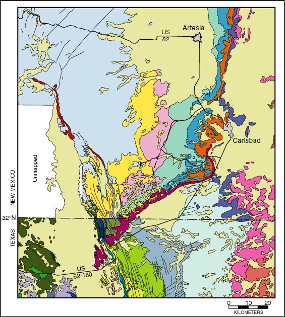
The Permian basin region was part of a stable, largely non-depositional province during Mesozoic time. Minor tectonic movements during the Laramide period, coupled with extensive uplift of the western part of the region during middle to late Tertiary Basin and Range block faulting, produced a significant (approximately 5-10°) regional eastward dip of pre-Tertiary strata (see diagram below; Grauten, 1965). This deformation led to erosional exhumation of original Permian topography on the western margin of the region, widespread influx of meteoric waters with renewal of deep ground-water circulation, dissolution and/or replacement of Permian evaporites, and widespread cavern formation in limestones of the Guadalupe Mountains. Tertiary uplift is directly responsible for the extensive, but scattered, exposures of middle to Late Permian shelf-to-basin facies along the western and southern margins of the former Delaware basin in the Guadalupe Mountains, Apache Mountains, and Glass Mountains of west Texas and New Mexico (see Permian basin physiographic diagram above). It is also responsible for the superimposition of numerous high-angle faults and fractures on the Permian rocks of the Guadalupe Mountains, especially along the western escarpment (King, 1948) these faults greatly complicate stratigraphic studies.
Stratigraphic Setting and Nomenclature
The Permian reef complex is characterized by three sections of time-equivalent but lithologically very dissimilar rocks. The first facies consists of thick masses of finely laminated siltstones and sandstones with thinner, interbedded, gray to black limestones. The second facies contains massive, light-gray limestones overlying steeply bedded, partially dolomitized, blocky limestone rubble. The third zone contains tan, fine-grained, medium-bedded dolomites with interbedded evaporites and red to brown sandstone and siltstone units.
As early as the late 1920's, it was recognized that these three rock packages represent strata deposited, respectively, in basinal, shelf-margin, and shelf-interior settings (Lloyd, 1929; Crandall, 1929; Blanchard and Davis, 1929). These conclusions were drawn largely on lithologic and structural criteria, but subsequent work (e.g., King, 1948; Newell et al., 1953; Babcock, 1977) on faunal, floral, sedimentologic, and stratigraphic aspects of these units has confirmed the initial conclusions.
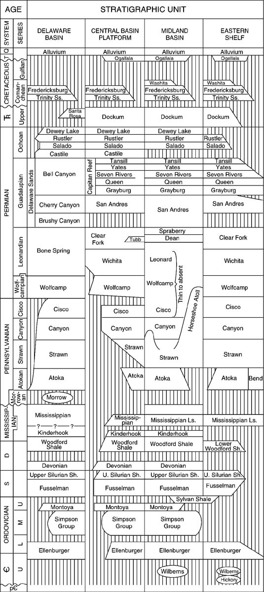
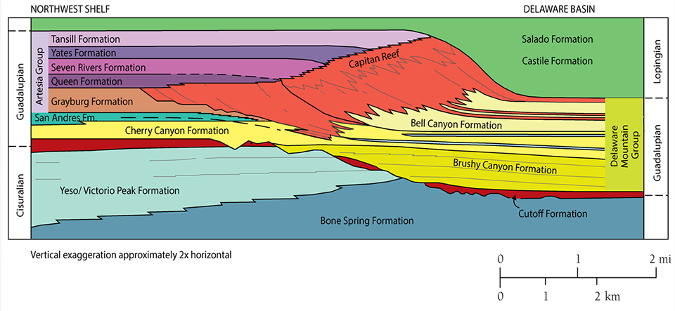
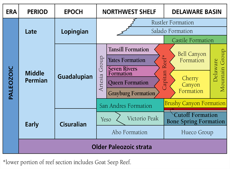
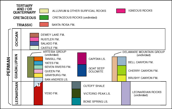
The stratigraphic nomenclature used in this guide largely follows the standard terminology of King (1948), Newell et al. (1953), Hayes (1964), and Tyrrell (1969), as are shown in the figures below; thus, the nomenclature will not be discussed in much detail. Table 1 shows the regional stratigraphic terminology for the entire Phanerozoic section; the second provides the terminology for the Guadalupian of the entire area; the third shows the detailed nomenclature used for basin and basin-margin strata only. The terminology for the Leonardian to Ochoan interval reflects the structurally-influenced depositional settings in the area shelf, shelf margin, and basin. For example, strata of the upper Guadalupian Goat Seep and Capitan Formations were formed in shelf margin settings as barrier reef boundstones and associated fore-reef debris aprons. The Queen, Seven Rivers, Yates, and Tansill Formations are the shelfal redbed, evaporite, and dolomite units which are age-equivalent to the Goat Seep-Capitan section. Likewise, the Bell Canyon Formation (which, along with the Brushy Canyon and Cherry Canyon formations, is part of the Delaware Mountain Group) represents the correlative, dominantly terrigenous, basinal section. Leonardian and early Guadalupian strata show similar shelf-to basin sequences but without reefal shelf margins. Ochoan strata are dominantly evaporites which fill remnant topography enhanced by differential Guadalupian shelf-to-basin carbonate sedimentation.
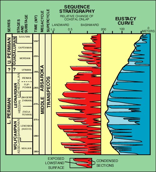
Numerous authors have pointed out that cyclic sedimentation of one sort or another is widespread in the Permian Basin in Pennsylvanian as well as Permian strata (e.g. Meissner, 1972; Silver and Todd, 1969; Wilson, 1972 ). Cyclic sedimentation operated at a number of scales, from fractions of a meter to hundreds of meters of sediment, and were superimposed on an apparently long-term drop in sea level throughout Late Permian time. Modern sequence stratigraphic studies have indicated that the large-scale cycles (diagram below) may be world-wide in extent (Ross and Ross, 1985b; Ross and Ross, 1987; Ross and Ross, 1988), and known Late Pennsylvanian to Early Permian glacial advances and retreats may have contributed to the generation of such cycles by creating periodic eustatic sea level changes (Crowell, 1978; Crowell, 1982).
Although dating of these southern hemisphere glacial events is far from exact due to the provinciality and endemism of the floras and faunas present, recent work indicates that the late stages of continental glaciation extend into the Late Permian. Glaciations, thus, may explain several large cycles within the Guadalupian, although probably not the major regression at the close of Guadalupian time (Caputo and Crowell, 1985; Frakes and Francis, 1988; Veevers and Powell, 1987). Epeirogenic events, late orogenic deformation in Appalachian and Hercynian regions, and variations in sea floor spreading may account for other Late Permian cycles. Moreover, regional basin subsidence patterns may have been episodic and could also have contributed to the cyclicity of sedimentation.
© Peter A. Scholle, 1999
© Peter A. Scholle, 1999
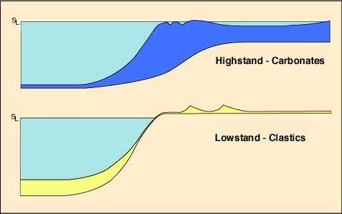
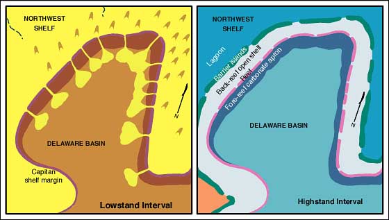
The concept of reciprocal sedimentation also helps to decipher a significant problem in Permian basin stratigraphy namely, the fact that the shelf margin sequences which ring the Delaware Basin are largely carbonate (generated in-situ), yet the basinal section is composed overwhelmingly of detrital terrigenous sandstone and siltstone. How did sands move into the basin while leaving so little record in the surrounding shelf-margin facies? In the reciprocal sedimentation (sequence stratigraphic) scenario illustrated below, carbonate sedimentation dominated during high sea level stands; reefs and/or grainstone shoals flourished, acting as carbonate "factories" on the platform margins; broad carbonate-evaporite lagoons occupied much of the shelf area, and thin but widespread carbonate turbidite units were deposited in the basins. Clastic terrigenous strata were either trapped in vegetated dunes or interdune flats, on sabkhas, or in shoreline deposits well up on the shelf. During lowered sea levels, on the other hand, fluvial (ephemeral stream) and eolian terrigenous sands and silts spread across the shelf areas, accumulated on their margins and eventually were transported into the basins to form thick sandstone sequences. In this concept, intervals of rapid shelf sedimentation correspond with times of slow basinal deposition and vice versa. Thus, although the basin, shelf-margin, and shelf-interior rock packages mentioned above are lateral time-equivalents of each other and have approximately the same overall thickness, this equivalence does not necessarily extend to smaller scale units. Laminated sandstones, which are tens to hundreds of meters thick in the basin facies, apparently have either very thin or no equivalents in the reef or back-reef sections. Likewise, reef and back-reef limestone and dolomite sequences which, again, may be tens to hundreds of meters thick on the shelf and slope, will commonly thin to less than a meter toward the basin center.
Alternatively, it is possible that some terrigenous material moved through channels or tidal passes in the barrier reef contemporaneous with carbonate sedimentation, for some lenticular sandstone beds and disseminated terrigenous sand grains have been found in shelf edge and upper slope carbonate units. Nevertheless, the cyclic distribution of both shelfal and basinal carbonate/clastic packages indicates that some degree of reciprocal sedimentation is required to explain overall sediment distribution.
A clearly defined seismic sequence stratigraphy has been developed recently for the Permian Basin region (eg. Sarg, 1985 and 1986), and it supports the concept of repeated relative sea level variations, probably related to eustatic cyclicity on a time scale of roughly a million years or less. In addition, field mapping of seismically-defined sequences (Sarg, 1985 ; Sarg, 1986; Ross and Ross, 1987) has led to the recognition of major erosion surfaces, low-stand depositional wedges, onlapping units, and other depositional features indicative of significant temporal changes in sea levels (see Fig. 8).
Depositional patterns are also controlled by long-term changes in subsidence versus sedimentation rates. When subsidence rates were high, or when sea levels were rising rapidly, facies tended to build vertically, as during the time of Goat Seep reef deposition. Conversely, with high rates of sedimentation and slow subsidence or minor sea level rise, facies progradation was predominant. This is nicely illustrated by the Capitan reef on the stable western margin of the Delaware basin (the Guadalupe Mountains) where the reef prograded nearly 10 km (6 mi) during Capitan sedimentation. On the more rapidly subsiding eastern margin of the same basin (the western edge of the Central Basin Platform) less than 3 km (2 mi) of progradation took place during the same interval (Ward et al., 1986). Perhaps even more dramatically, both the Midland and Delaware basins were completely filled by extremely high rates of deposition of clastic terrigenous, carbonate, and evaporite strata. The Midland basin ceased to be a marine sedimentation site at about the time that the Capitan reef started growing around the Delaware basin, and the Delaware basin itself was entirely filled by very rapidly deposited (>4 km/my) evaporites during early Ochoan time.
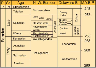
Interbasinal and intercontinental correlations of Permian strata are difficult, largely because faunas in the major depositional areas are largely endemic. Furthermore, the Permian type sections in the Soviet Union are, at least partly, in non-marine strata. Fusulinid and conodont biostratigraphic studies have, to date, been most successful in tying together the widely dispersed Pangean Permian (Babcock, 1974; Rasmussen et al., 1990; Ross, 1987; Ross and Ross, 1985a; Wardlaw and Collinson, 1986; Wilde, 1988; Wilde, 1975), but recent advances in both isotopic stratigraphy and sequence stratigraphy have also proved useful (Burke et al., 1982; Ross and Ross, 1988). While far too complex a problem to summarize in this guide, the mid-Permian (mainly Guadalupian) strata of west Texas and New Mexico are considered to be generally correlative with the Phosphoria-Park City-Goose Egg deposits of Idaho and Wyoming, as well as the extensive Zechstein deposits in Europe (see correlation chart).
Depositional Patterns
© Peter A. Scholle, 1999
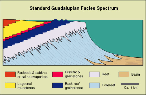
Because this discussion will examine the full suite of shelf-interior, shelf-margin, and slope to basinal strata in the Guadalupe Mountains (see Table 2), it is appropriate to describe the general characteristics of deposits in each of those settings. More detailed descriptions of individual microfacies are also found in the roadlog section under the descriptions for specific outcrop stops.
Shelf interior facies - The farthest shelfward units to be considered here are redbeds which are interpreted to have been deposited on broad, sabkha-like plains (Kendall, 1969). Clastic terrigenous detritus was derived from the north, northeast, and perhaps also the northwest, largely from remnant basement uplifts in the Ancestral Rockies and other areas. Transportation of the subarkosic sediment was probably partially accomplished through fluvial (especially ephemeral stream) processes but was more likely dominated by eolian (dune/dust storm) reworking.
© Peter A. Scholle, 1980 and 1992

© Peter A. Scholle, 1999

© Peter A. Scholle, 1999

© Peter A. Scholle, 1999
The massive redbeds, as well as thinner sandstone units interbedded in the shelf sequences, display few sedimentary structures. Evaporite nodules are common, and faint traces of horizontal lamination, adhesion ripples, low-angle cross-bed sets and similar structures can be seen locally; trace fossils are virtually absent. This is consistent with deposition on an evaporitic plain across which large dunes may have migrated, yet in which the only sediments trapped were those held by a capillary fringe above the water table (e.g., Glennie, 1970).
Beds of gypsum (or anhydrite in the subsurface) are complexly interstratified with the redbeds on their seaward margin. The evaporites typically have nodular fabrics but also are found as rosettes or radiating bursts of crystals. Deposition of evaporites has been interpreted to have taken place by direct precipitation in shallow pools or lakes (salinas) as well as through displacive nodular growth in sabkha flats (Kendall, 1969; Sarg, 1981).
Extensive dissolution of shelf evaporite beds has led to widespread solution-collapse brecciation. Although it is possible that much of this dissolution is a result of near-surface weathering during Tertiary uplift, the presence of solution breccias in age-equivalent strata in the deep subsurface makes it likely that at least some of this brecciation is of Permian age. Probably pluvial-interpluvial climatic cycles existed in association with Permian glaciations just as they did during the Pleistocene (e.g. Benson and Thompson, 1987); this may have led to alternating phases of evaporite formation and dissolution.

© Peter A. Scholle, 1999

© Peter A. Scholle, 1999
Seaward of the main evaporite deposits, and again complexly interstratified with the evaporites and redbeds, are fine-grained, thin-bedded dolomicrites (dolomudstones). These too were probably deposited in a shallow subtidal or lacustrine setting a coastal salina or a hypersaline marine lagoon (Sarg, 1981). Constituents include irregular pellets or peloids, some oncoids, calcispheres, and foraminifers, plus local algal stromatolite boundstones. Other fossils are generally scarce to absent. The micrite matrix and allochems have been replaced, presumably penecontemporaneously, by very finely crystalline dolomite which preserved primary fabrics. Although some of these strata have considerable moldic and fenestral porosity on outcrop, equivalent units in the subsurface generally are completely plugged with evaporite minerals, especially anhydrite. Such minerals rarely survive outcrop weathering, but crystal molds or calcitized evaporites are commonly found in outcropping strata on the landward side of this facies belt. This supports the idea that outcrop and subsurface strata both shared a high original percentage of evaporitic constituents.

© Peter A. Scholle, 1999

© Peter A. Scholle, 1999

© Peter A. Scholle, 1999

© Peter A. Scholle, 1999
Interbedded with these dolomicrites are numerous thin (20 cm to 2 m) beds of clastic terrigenous sand. These terrigenous units contain material very similar to that which predominates in the redbed facies very fine sandstone and coarse siltstone with a subarkosic composition, few sedimentary structures and essentially no fossils or trace fossils. Such beds probably represent small progradational advances of sabkha-type sedimentation across the back-reef lagoonal area as a consequence of cyclic changes in climate, sediment supply or sea level. Some of the individual sandstone beds extend seaward for several kilometers but thin and eventually pinch out before reaching the shelf-margin reef facies (Candelaria, 1982). Despite their thinness and lack of continuity in a seaward direction, however, some of the more prominent sands have considerable extent parallel to the shelf edge. These form excellent marker units which have been mapped over many tens of thousands of square kilometers in the subsurface as well as in surface sections.

© Peter A. Scholle, 1999

© Peter A. Scholle, 1999

© Peter A. Scholle, 1999
Immediately seaward of the dolomitized carbonate mudstones lies what is probably the most controversial facies in the Permian of the Texas-New Mexico area. The "pisolite facies" is a tract, a kilometer or more wide, which persists throughout the Grayburg to Tansill section (ie. about a kilometer of sedimentary buildup). It consists of irregularly bedded deposits of laminated, fenestral carbonate, beds of skeletal debris, and most importantly, abundant lenticular zones of pisolitic dolomite. The pisoids range in size from a few millimeters to greater than 5 cm; they commonly have a reversely graded structure, with finer pisoids at the base and coarsening upward (Dunham, 1969). However, cross-bedded and unsorted pisolitic deposits are also present. Pisolitic strata typically contain some marine fossils, especially on the seaward side of the facies. Pisolitic nuclei include some marine fossils but are dominantly fragments of older pisoids. In their later stages, pisoids grow "in place", developing fitted fabrics, common or shared coatings, and passing into botryoidal crusts of former aragonite "marine" cements (Dunham, 1969; Loucks and Folk, 1976; Scholle and Kinsman, 1974). The pisolite facies has been extensively replaced by very early (penecontemporaneous), aphanocrystalline dolomite crystals which clearly mimic primary fabrics. Although very porous on outcrop, this facies again shows extensive filling by evaporite minerals in most subsurface sections.

© Peter A. Scholle, 1999

© Peter A. Scholle, 1999
The pisolitic deposits are found in association with large (1-3 m/3-10 ft high; 10-25 m/30-80 ft diameter) polygonal features termed "tepee structures" (Dunham, 1969; Kendall, 1969). These are polygonal expansion features which are marked by buckled and deformed sediments, crusts of precipitated, originally aragonitic cement , and pockets of pisolitic sediment beneath and between the polygonal upwarps. Tepee structures are usually stacked; that is, they build up through a series of successive beds until they are truncated or otherwise terminated by a thin sandstone or carbonate grainstone bed.
The pisolite facies is always found as a transitional zone between fossiliferous marine grainstones, packstones, and wackestones on the seaward side and the largely barren, evaporitic dolomicrites on the landward side. As such, it must represent or be associated with a long-lived barrier to water movement between open shelf and lagoonal settings. The detailed interpretation of the environment of deposition of this unit has, however, been the subject of very diverse speculation over the years. Pisolite formation was originally attributed to marine growth of algal nodules but has been reinterpreted as a product of marine inorganic precipitation in a subtidal setting (Esteban and Pray, 1977); caliche formation in continental or coastal spray-zone settings (Dunham, 1969; Scholle and Kinsman, 1974); and back-barrier, marine seepage or groundwater springs (Handford et al., 1984).
This last hypothesis appears to be a very viable interpretation and is based on a number of studies of modern coastal salinas, lakes and sabkhas in southern and western Australia (eg. Warren, 1982, 1983, 1985; Logan, 1987; Handford et al., 1984; Kendall and Warren, 1985). In the more arid settings, evaporative drawdown of lakes and lagoons which lie behind marine or eolian grainstone barrier ridges allows the constant seepage of marine waters through the barriers. This results in the formation of pisolitic, aragonite cemented crusts around the spring-like inflow areas. Continued growth of aragonite crystals leads to development of fractured, tepee-like crusts which can build up through several meters of section. In more humid or seasonally wet areas, focusing of discharge areas of rainwater seepage by a variety of features also leads to similar spring formation with equivalent aragonitic tepee-pisolite deposits (Lock and Burne, 1986). The seep-spring hypothesis, based on its modern Australian analogs, closely matches many of the observed features in the Permian pisolite belt:
- The Permian pisolitic units are associated with a significant and persistent barrier between normal marine and hypersaline or otherwise restricted settings.
- Pisolitic beds are associated with tepees which remain in relatively fixed positions through significant periods of time.
- The pisoids are distributed in small pockets or patches which could represent localized seepage areas.
- Permian sandstone units do not thin over the pisolite facies so that it is unlikely that this facies was itself an elevated barrier as required by caliche hypotheses thus a back-barrier seepage area fits the topographic constraints.
- The Permian pisolitic units contain "marine" (formerly aragonitic) cements but are largely dolomitized. This is common in modern salina settings where marine pore fluid seeping into the basin yield aragonitic and high-Mg calcite cements and where subsequently evaporated brines produce dolomitization.
- Cross-bedded, reworked or fossiliferous deposits should be common in a back-barrier setting which may frequently be breached by storms. Such deposits, containing rounded molluscan or fusulinid grains, are common in the Permian strata.
© Peter A. Scholle, 1999
© Peter A. Scholle, 1999
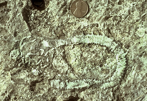
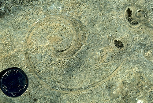
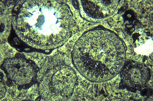
Shelf margin facies - The deposits which lie seaward of the pisolite zone (see facies spectrum diagram above) contain a wide variety of lithologies. Generally, these strata show signs of open marine circulation, with normal or only slightly hypersaline conditions. The rocks are typically rich in marine fossils, especially fusulinids and other foraminifers, gastropods, pelecypods, green algae (especially Mizzia and Macroporella), blue green algal boundstones, oncoids, and other skeletal grains. Bedding is indistinct on the seaward side of the facies but becomes well defined and medium-scale on the shelfward side. Grainstones and packstones predominate but some wackestones and algal boundstones are also present in localized areas.

© Peter A. Scholle, 1999
© Peter A. Scholle, 1999

© Peter A. Scholle, 1999
Sedimentary structures vary greatly on a small scale and include several types of cross bedding; trough sets, bi-directional or herring-bone units, and seaward-dipping, low-angle planar sets all are commonly observed. Fenestral fabrics, slightly pisolitic teepee structures, channels, and crudely graded storm beds also are encountered. In general, shallowing-upward (subtidal to supratidal) sequences are very abundant and occur on small as well as large scales (meters to hundreds of meters).
If, as concluded previously, the pisolite barrier does not represent a topographically elevated area, then this facies, its seaward neighbor, must be such a region. The combination of varied, small-scale facies, shallowing upward sequences, marine fauna, thinning of associated sandstones and other features all indicate that the seaward area of this facies was a zone of small, coalescing sand waves and islands, perhaps with intervening tidal passes. Quite possibly, the landward third of the facies, in which storm beds, tepees, and possible soil crusts are common, represents a more continuous and more permanent low-relief barrier island facies. However, whether through the presence of a single continuous marine-eolian barrier or through a series of coalescing, shifting islands, this facies acted as an overall deterrent to water movement farther landward.
The grainstone-island facies is as complex and varied from a diagenetic point of view as it is from a depositional perspective. Locally, massive marine cements occlude all porosity (especially on the seaward margin). In other cases, minor marine cement is accompanied by vadose and/or phreatic fabrics, leaching of unstable (originally aragonitic and high-Mg calcite) grains, and development of moldic porosity. This is not surprising in an area of shifting islands where small fresh-water lenses may penetrate sections which were formerly in marine pore fluid settings. Unlike any of the shelf interior facies, however, the island belt underwent only partial dolomite replacement and relatively minor evaporite pore-filling cementation (both probably related to subsequent progradation of more shelfward units over this facies). Thus, rocks of this facies are prolific reservoirs in the subsurface both because to their inherent porosity and because of their close proximity to updip and overlying evaporite-plugged seals.
Just seaward of the grainstone-island belt lies the main carbonate-producing facies of the area, the reef. This microfacies forms a sharply defined, largely continuous, shelf-margin zone which surrounds the Delaware basin. Although the reef shows broad bends and embayments on a scale of kilometers, massive bedding and weathered or inaccessible outcrops have precluded mapping of smaller-scale reef structures such as channels or spur-and-groove morphology.
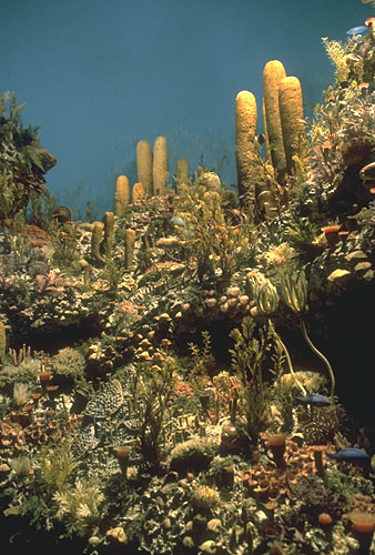
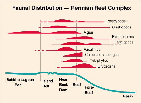
The Capitan reef is a zone of maximum faunal diversity (figure below). The major framework organisms in the reef complex include calcareous sponges plus Tubiphytes (a possible hydrocoralline); phylloid algae locally form a subsidiary framework. These organisms, commonly still found in living position, are encrusted by possible red or blue-green algae (Archaeolithoporella, Solenopora, Collenella, and others) and are arranged in a consistent pattern of subfacies which probably reflect changing environmental conditions passing up the slope and onto the shelf (J. Babcock, 1977; Toomey and Cys, 1977). In addition to framework and encrusting organisms, the reefs contain a wide range of ancillary organisms echinoderms (including crinoids and echinoids), bryozoans, brachiopods, mollusks, ostracods, scarce solitary corals and trilobites, and others. On the shelfward side of the reef, sponge-algal rubble passes into Tubiphytes thickets, and Mizzia and Macroporella green algal grainstones with scattered belerophont gastropods. This is very reminiscent of the sequence of microfacies across a modern Caribbean reef (e.g. Ginsburg, 1964 ; Multer, 1969), with coral rubble passing into sandy flats dominated by Halimeda green algal grainstone with grazing belerophontid gastropods (conchs) and echinoderms.
© Peter A. Scholle, 1999

© Peter A. Scholle, 1999
© Peter A. Scholle, 1999
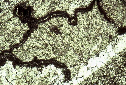
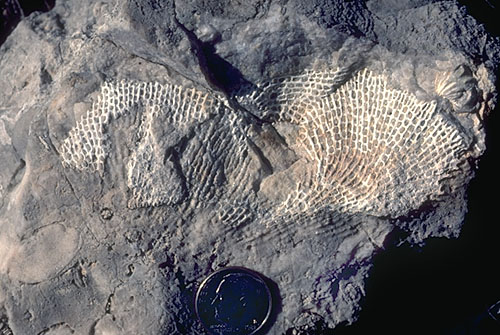
A major factor in the formation of these late Guadalupian reefs was the massive amount of penecontemporaneous marine cementation which took place at or near the shelf margin (Mazzullo and Cys, 1977). Large and small cavities alike were rapidly filled with massive, botryoidal crusts of radial-fibrous cement . The cement is partly intergrown with Archaeolithoporella encrustations, internal sediment, and even sessile macrofossils, all of which attest to the syndepositional nature of the cementation by originally aragonitic and/or high-Mg calcite cements. Massive marine cementation is largely confined to the reef facies and the immediate near-back-reef grainstones and in most cases has reduced porosity to such a degree that these units are not significant hydrocarbon reservoirs despite the fact that locally extensive fracturing has given some of these zones high permeability.
© Peter A. Scholle, 1999
As with many ancient reefs, there has been considerable discussion over the past few decades as to whether this was a "true" ecologic reef, whether it was a continuous or discontinuous barrier, and whether it developed at the topographic crest of the shelf or in deeper water on the upper slope (Achauer, 1969; Dunham, 1970 and 1972; Schmidt, 1977; Hurley, 1979; Saller, 1996). Various workers have considered the Capitan to represent an unconsolidated shelf margin skeletal bank or mound (Lang, 1937; Achauer, 1969), a true barrier reef (Newell et al., 1953; Kirkland and Moore, 1990 and 1996), or an uninterrupted slope facies (King, 1948). Others have felt that the abundance of penecontemporaneous marine cement indicated that the wave-resistant nature of the Capitan "reef" was a result of primarily inorganic rather than biological processes making this a "cement reef" rather than an "organic or ecologic reef" (Schmidt and Klement, 1971). Some have even interpreted much of the observed reef fauna as having lived within carvities of a cement reef (Wood et al., 1994 and 1996).
Overall, the high biological diversity of this environment (see Table 2 and and faunal distribution diagram above); the abundance of framework calcareous sponges, bryozoans, and hydrocorallines; the ubiquitous presence of encrusting organisms (Tubiphytes, Archaeolithoporella, Girvanella, and others); the remarkably high productivity of organisms generating vast masses of reef and fore-reef skeletal debris); the distinct internal faunal zonation (see microfacies distribution diagram below); the presence of abundant inorganic, radial-fibrous, originally aragonitic cements; and the large-scale fragmentation and disruption of fabrics by wave and current activity are all features of the Permian reef complex which are highly analogous to modern reefs.
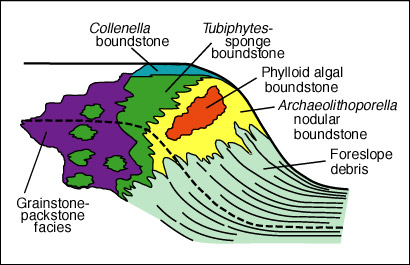
Indeed, much of the semantic confusion over the reefal nature of the Capitan Formation revolves around the presence or absence of in-situ biological growth fabrics. That confusion is a result of trying to transfer the common definition of modern reefs as "stable, wave-resistant, frameworks" into the geologic record. The wave-resistance concept, however, is largely a misconception produced by the "fair-weather" examination of modern reefs. On a clear, calm day, when most geologists venture forth, the modern reef is truly wave-resistant, consisting of abundant, in-situ framework organisms. The day after a hurricane, however, much of this "wave resistant framework" has been smashed into rubble which accumulates within the reef or is transported into deeper water settings. Indeed, quarries in Pleistocene or older reefs show only a small percentage (typically 10-25 percent) of in-place framework organisms (e.g. Stanley, 1966).
© Peter A. Scholle, 1999
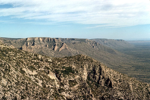
The work of Newell et al. (1953), Babcock (1977), and Babcock and Yurewicz (1989) has established the existence of consistent faunal zonation within the Capitan reef (Fig. 14) and has demonstrated that much of the fauna is still in living position, at least in the few areas of exceptional exposure which were studied. To a considerable degree, this has demonstrated that the Capitan contains at least local "true reef" limestones, but it has also stimulated further questions about the environmental setting of the reef growth. Some have argued that the preservation of delicate, branching or plate like organisms, the presence of roll-over bedding at the shelf margin, plus other factors all indicate that reef growth took place in deeper water on the upper slope below the reef crest (Hurley, 1979; Pray, 1985). One can see considerable evidence, however, of wave reworking of the most shelfward parts of the reef, with transport and rounding of blocks up to a meter across. In addition, it seems unlikely that in an enclosed basin, with less than 160 km (100 mi) maximum fetch, generation of waves of sufficient size to destroy cemented reef fabrics would be a common occurrence, even if the reef grew in shallow, unprotected waters.

© Peter A. Scholle, 1999
© Peter A. Scholle, 1999
Regardless of semantic questions, the rapid rate of marine cementation of the reef facies, coupled with the very high rate of biological productivity, meant that during much of Guadalupian time more material was generated in the reef margin zone than could be accommodated there given limited rates of subsidence. This excess material was transported into back-reef and, more importantly, fore-reef environments. Thus, the Capitan reef of the Guadalupe Mountains prograded seaward between five and ten kilometers (3-6 mi) despite sitting at the margin of a nearly 600 meter (1,800 ft) deep basin. This clearly required a very large volume (and a high rate) of sediment production.
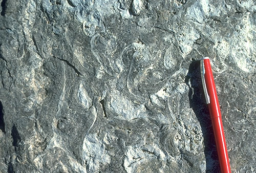
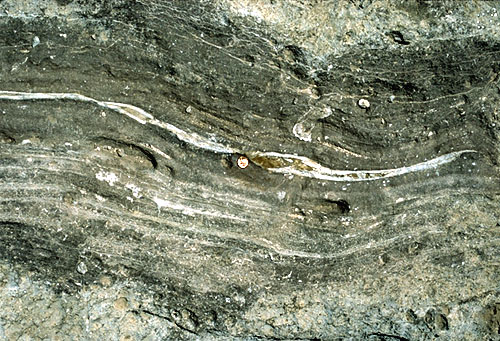
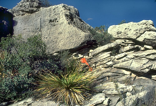
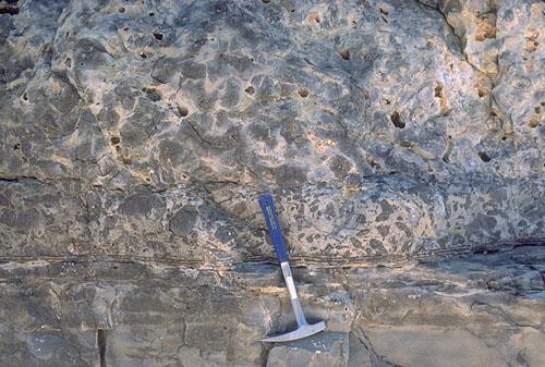
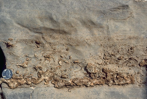
The intense penecontemporaneous cementation of the Capitan reef, coupled with the fact that it prograded rapidly over 500 or more meters (1,600+ ft) of largely unconsolidated and compactible debris, led to extensive syndepositional fracturing of the cemented reef slab (King, 1948). As bedding is largely absent in the massive reef facies, weathering has exposed these shelf-edge-parallel fractures which were filled with internal sediment, encrusting organisms, and, most commonly, by paired zones of marine cements on the fracture walls. Clastic terrigenous sand grains are also found in some of the late-stage fillings of these fracture sets, giving evidence that terrigenous sands indeed passed over the Capitan shelf margins. The fractures, which weather in sharp relief relative to the surrounding rock, also form the easiest way of recognizing the reef zone in the field. The pictures nearby show the cementation of the reef and the orientation of the fractures.
© Peter A. Scholle, 1999
© Peter A. Scholle, 1999
© Peter A. Scholle, 1999
© Peter A. Scholle, 1999
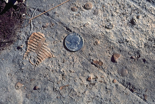
Slope and basin facies - One of the most volumetrically important carbonate facies in the Permian reef complex is the fore-reef talus apron. These deposits consist of steeply dipping rubble of reef, near-back-reef, and upper slope origin combined with sediment formed in-situ on the middle and lower slope. Brachiopods, fenestrate and ramose bryozoans, and echinoderms were the most common organisms to have lived on the slope; siliceous sponges added significantly to the biomass only in base-of-slope settings. Slope sedimentation, however, was overwhelmingly dominated by allochthonous material transported by rock fall, grain flow, debris flow, and turbidity current processes. The slope facies thus consists of innumerable individual, small, allochthonous deposits which have coalesced to form a relatively uniform apron of debris (see Bebout and Kerans, 1993; Brown and Loucks, 1993a; Brown and Loucks, 1993b).
Bedding generally is distinctly visible in canyon exposures which dissect the shelf margin. Bedding angles exceed 35 degrees on the upper slope and flatten gradually to only a few degrees as one approaches the basin floor. Individual beds vary in thickness from a few tens of centimeters to several meters and typically wedge out laterally. Much of the sedimentation was controlled by small canyons, channels or slump scars on the slope. These sites acted as sediment conduits until they were plugged by massive debris or grain flows and new channels became active. Grain-flow deposits typically contain fusulinid foraminifers and other near-back-reef material which may have passed through tidal gaps in the Capitan reef. The bulk of the sediment, however, consists of poorly sorted or unsorted reef detritus either small fragments and individual constituent grains or larger blocks of lithified (encrusted and cemented) reef framework. The size of the blocks, the massive bedding, the interstitial matrix of reefal material, and the degree of diagenetic alteration commonly make it difficult to impossible to consistently differentiate Capitan reef and fore-reef strata either in the field or the subsurface where the geometric relationships of the entire shelf margin cannot be seen.
Clastic terrigenous material is scarce in middle and upper slope strata. In some horizons, well-rounded terrigenous sand grains and more angular silt grains are disseminated among the predominant carbonate constituents. Isolated terrigenous sand-filled channels are found in other sites; these channels can be up to 10 m (30 ft) thick. The lowest part of the slope, on the other hand, shows extensive interfingering of carbonate debris beds, which thin basinward, with sandstone beds which show the opposite relationship.
The slope area is just as complex from a diagenetic perspective as it is from a depositional viewpoint. Fluids from basinal and shelf sources likely passed through and mixed in this environment (Scholle et al., 1992). Compaction is extensive below the marine cemented zone at the very top of the slope. Post-depositional, moderately coarsely crystalline, selective dolomitization is very widespread and, in places, completely alters the slope strata (Melim and Scholle, 1992; Melim, 1991). Late diagenetic porosity filling by gypsum, anhydrite, kaolinite, and other minerals is commonly seen in the subsurface although on outcrop most of the evaporite minerals have been converted to coarsely-crystalline calcite. Directly precipitated calcite cements also are present in upper slope strata where fresh-water input has occurred (Given and Lohmann, 1986; Mruk, 1985 and 1989; Scholle et al., 1992; Wiggins et al., 1993). Slope strata, either despite or because of these varied diagenetic events, form producing reservoirs in some of the older (mainly Wolfcampian and Leonardian) sections along the edges of the Delaware and Midland basins (Wiggins and Harris, 1985; Hobson et al., 1985; Mazzullo and Reid, 1987).
© Peter A. Scholle, 1999
Toward the base of the slope, the character of the fore-reef deposits changes significantly. Bedding becomes thinner and more graded beds are present; furthermore, the sediment is finer grained, darker colored, more stylolitic, and contains more siliceous biota than do strata from upper or middle slope settings. Dolomite is largely lacking in these beds but compaction, stylo-nodular bedding, silica replacement of calcitic fossils, and chert nodule formation are important factors in the virtually complete destruction of porosity in this part of the slope.

© Peter A. Scholle, 1999
The lower slope beds thin rapidly as they pass smoothly into the basinal carbonate sections. The Lamar Limestone (the youngest of the Guadalupian basinal carbonates), for example, thins from nearly 40 m (130 ft) at the base of the slope to about 1 m (3 ft) within 15 km (10 mi) basinward. Basinal carbonates are typically very fine grained, have only traces of grading (although they probably are distal turbidites), and are generally finely laminated and dark-colored. Organic carbon contents, however, rarely exceed one percent. These strata are mostly devoid of fauna although a few radiolarians have been described. Burrowers and other benthic organisms are present along the basin margins but are generally lacking in the basin center areas. This provides evidence that the basin centers may have been occupied by oxygen depleted waters, perhaps dense, saline brines from the shelf (L. Babcock, 1977).
As was noted earlier, the thin, detrital carbonate beds do not form a volumetrically important part of the Guadalupian fill of the Delaware and Midland basins. Clastic terrigenous sandstones and siltstones, transported from the shelves either through penecontemporaneous channels in the reef or during episodic events of sea level lowering, provide greater than 90 percent of the fill. These strata consist of subarkosic, very fine-grained sandstones and coarse siltstones which are compositionally very similar to the thin clastic terrigenous units found on the shelf. The coarser sand grains are generally well rounded and frosted. Carbonate grains of shelfal origin, especially fusulinid foraminifers, were entrained in the sandstone deposits and ultimately also contributed to the generation of widespread carbonate cement in the clastic units.

© Peter A. Scholle, 1999
Large-scale sedimentary structures in the basinal sandstones are dominated by the sinuous channels, levees and overbank deposits typical of submarine fan complexes (Williamson, 1977). Elongate channels can be seen in outcrop where they are filled with amalgamated, generally clean and well sorted sands. Slumps, flame structures, and sand-injection structures are commonly associated with these channel and overbank deposits. Submarine channels have also been mapped in the subsurface, especially in the Bell Canyon Formation, where they are major exploration targets. The channels sands have porosities as high as 27 percent (Williamson, 1977), although the small average grain size results in low permeabilities and low oil recovery factors. In the Bell Canyon Formation, sandstones were mainly derived from the northern and northeastern sides of the basin; data are poorer for Cherry Canyon and Brushy Canyon intervals but sediment transport there appears to have been dominantly from the north and northwest.
Smaller-scale sedimentary structures are dominated by horizontal lamination, although some rare small-scale channels, starved ripples, cross-bedding, flute casts and related structures also have been observed. The scarcity of structures produced by bottom currents and the predominance of horizontal lamination led Harms (1974 and 1988) to propose a "density overflow" hypothesis. In this scenario, unstable, unconsolidated sands delivered to shelf settings by unspecified (presumably ephemeral stream and eolian) processes were carried into the basin by salinity currents generated in evaporitic lagoons which may have been shifted close to the edge of the shelf during relative lowstands of sea level. These comparatively low-density currents transported very fine-grained sands and silts into a basin which already had dense, high-salinity brines at the base of the water column. A significant number of the saline, sand- and silt-laden currents were unable to displace the existing bottom waters and therefore flowed out across the interface between the basal brines and the less dense overlying fluids. As these "density overflows" (really interflows) slowed, entrained sediment was rained down producing a laminated deposit devoid of traction structures.
Alternatively, direct eolian input by major dust storms could have contributed laminated silts and very fine sands to much of the area of these small basins on an episodic basis (Fischer and Sarnthein, 1988). Furthermore, it is possible that some terrigenous sands passed across the shelf margins even during relative sea level highstands, probably by transport through channels or tidal passes in the reef barrier. Discrete, errigenous sand-filled channels are abundant in outcrop and subsurface sections of the Capitan fore-reef talus facies. These channels have not been tied to subaerial exposure horizons on the shelf and have not been shown to occur in any cyclical pattern on the slope. Thus, they may mark sites of clastic terrigenous sediment bypass through a dominantly carbonate system even during relative highstands of sea level.

© Peter A. Scholle, 1999
Mapping of the distribution patterns of sandstones in the Delaware basin has been undertaken in order to answer the question of episodic or continuous sand transport into the basin as well as to delineate changes in terrigenous sources through time (Geisen and Scholle, 1990). The results to date have supported the concept of highly cyclical input of sands rather than continuous bypass supply. During most intervals examined, the preponderant terrigenous influx has been from the north and east of the Delaware basin and entered through ten or more major conduits (probably accompanied by dozens of smaller supply passages) rather than through a single channel.

© Peter A. Scholle, 1999
Within the basinal sandstones one also occasionally finds coarse debris-flow deposits which represent catastrophic failures of parts of the shelf margin. Such deposits contain huge blocks of carbonate slope debris and apparently travelled as far as 10 km (16 mi) into the basin without significant disruption of underlying unconsolidated sands. The largest of these deposits form elongate tongues of debris with volumes comparable to large modern landslides (Newell et al., 1953; Rigby, 1957).
Post-Capitan sedimentation - Deposition of carbonate reefs and associated carbonate shelf sedimentation was largely terminated at the end of Guadalupian time, presumably as a consequence of increased restriction of circulation and elevated salinities in the Delaware basin. The remnant basin was then rapidly filled by massive evaporites during Ochoan time. The first phase of filling was the Castile Formation, an unusual deposit of millimeter-scale interbedded laminae of gypsum (anhydrite in the subsurface) and organic matter plus calcite. The laminae are planar and highly continuous they have, in fact, been correlated over much of the Delaware basin (Anderson et al., 1972). Approximately 260,000 lamination cycles have been counted and these have been interpreted as varves, with the gypsum representing evaporative summer-fall layers and the organic matter plus calcite reflecting more normal salinity winter-spring conditions. The laminae also have been shown to reflect Milankovitch-scale climatic variability including precession (circa 20,000 year) and eccentricity (100,000 year) cycles (Anderson, 1984). This combination of characteristics suggests that the Castile evaporites were deposited in water depths of tens to hundreds of meters (at least below wave base).
The Castile sediments filled the Delaware basin and evaporite sedimentation then spread across the surrounding shelfal regions. Water depths were undoubtedly much shallower at this stage and conditions became even more hypersaline with deposition of the anhydrite, halite, sylvite, and other bittern minerals of the Salado Formation. Commercial deposits of potash minerals have been exploited in these thick, last-stage fillings of the Delaware basin and its marginal areas. Water depths during this phase were probably quite shallow, perhaps of the order of a few meters or less (Lowenstein, 1983 and 1988).
Subsequent to formation of the Salado evaporites, sedimentation in the area was dominated by nonmarine redbed deposition which extended into the Triassic Period, completing the cycle of progressive desiccation and filling of the Permian basin region. These evaporites preserved the geometry of the basin and provided the excellent seals needed to trap a high percentage of the oil generated from the rather sparse basinal source rocks. Finally, the removal of some of these evaporites during the Tertiary has given us the spectacular present-day outcrops of the Guadalupe Mountains and its surrounding areas.
General relations - The nature of, and the interrelationships between, the shelf-interior, shelf-margin, and basin facies are governed by a number of factors. Eustatic sea level stands and(or) relative rates of subsidence versus sedimentation, as mentioned earlier, can lead to "reciprocal" sedimentation patterns. Ecological conditions, such as water temperature, salinity, turbidity, or other factors, can affect reef formation and, thus, overall facies patterns. Indeed, just within the Permian facies of the Guadalupe Mountains region, one can see remarkable variations in microfacies patterns, especially in shelf-margin settings. Bank margins of non-reefal bioclastic calcarenite are present in some intervals (Victorio Peak and Getaway units); reefs which prograde largely horizontally out over reef talus are dominant at other times (upper Capitan unit). Yet other reefs which build up almost vertically in the section form the bank margin in the Goat Seep unit. Finally, terrigenous sand sheets cover the entire region from back-reef to basin at other times. So the discussion of facies patterns in the Permian basin region must take into account these major variations in modifying factors.

The climatic setting of the Permian reef complex also had a major influence on both depositional and diagenetic processes. The region lay at the western margin of a broad alluvial plain to the west of the Appalachian mountain area. The basin was presumably connected to a major western and southern ocean by narrow channels (see Permian basin physiographic diagram nearby). The entire region clearly had a hot and very arid climate, as evidenced by the extensive back-reef evaporite deposits.
During Guadalupian and earlier time, water circulation in the Delaware basin apparently was adequate to maintain normal marine salinity of the surface water along the bank margins. Waters penetrating deeper onto the banks were evaporatively concentrated to high salinities. Generation of heavy brines on the banks, which periodically flowed into the basin, may have contributed to euxinic, stratified water masses in the deeper parts of the Delaware and Midland Basins. Progressive restriction of the passageways between the Delaware basin and the "open oceanic" areas to the south and west led to apparent salinity increases and extinction of reef growth in the region at the close of the Guadalupian and continued aridity, coupled with restricted influx of marine waters led to the completely filling the topographic depression left after Guadalupian time with evaporites. The extreme aridity of the region also had other influences. Transportation of clastic terrigenous debris was dominated by eolian processes. Equilibrium eolian deflation surfaces (sabkhas) are present in back-reef areas and dune migration may have been responsible for transport of a significant volume of sand to the shelf edge from where it could be moved into the basin, especially during low stands of sea level. Although few dunes are preserved in the Permian basin, large Permian dune fields have been described from areas to the north and west in Colorado, northern New Mexico, Arizona and Utah (Reiche, 1938; McKee et al., 1967).
Aridity also presumably prevented the formation of extensive karstification during sea level drops, allowed the development of widespread "coastal caliche," and led to the formation of hypersaline brines which may have contributed to the extensive dolomitization of back-reef carbonate sediments.
The question of relative sea level changes, mentioned previously as part of the model of "reciprocal sedimentation," should also be examined further. Regional subsidence, local tectonic effects, eustatic sea level stands, and epeirogenic movements all can play a role in relative sea level stands. Other factors, such as variations in sedimentation rate, also can yield apparent changes due to progradation or retrogression of shorelines. Recent work (Franseen et al., 1989; Melim and Scholle, 1989b; Sarg, 1985) has indicated that a number of important, if subtle, discontinuity surfaces can be traced across the region and the next decade will undoubtedly see further exploration of the influences of such "events" on both depositional and diagenetic patterns. Older ideas of "all wet" shelf sedimentation (Pray, 1977) no longer are tenable in light of these recent studies.
Diagenetic Patterns
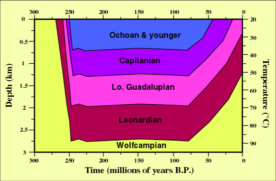
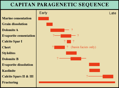
Diagenetic features have already been discussed to some degree under the individual environments, but more generalized patterns of diagenesis in the Guadalupian section are outlined in Table 2 and in the diagram below. This is a region with a relatively simple burial history consisting of rapid burial during the Permian, stability during the Mesozoic and part of the early Cenozoic, and then tectonic tilting and uplift during the later Cenozoic. Thus, most diagenetic alteration occurred either during the Permian (close to the surface at or near the time of sedimentation or during initial burial) or during the late Cenozoic.
© Peter A. Scholle, 1999
The back reef province is characterized by the highest average porosities. The areas which were topographically highest (such as island facies) were frequently subjected to subaerial exposure and freshwater diagenesis. Evaporitic conditions in restricted lagoons and sabkhas led to the formation of evaporite minerals (gypsum and anhydrite). The withdrawal of these calcium sulfate minerals from the shelfal waters led to elevated Mg/Ca ratios and perhaps also to the formation of dolomitizing brines as in the modern Persian Gulf. Alternatively, but less probably, freshwater input and mixing with marine pore fluids may have led to dolomitization through "brine mixing" ("Dorag" dolomite). Thus, the back reef areas of the Permian reef complex are typified by calcareous grainstones and mudstones with a mixture of preserved primary porosity and secondary porosity related to such factors as early freshwater cementation and leaching, early dolomitization, or late (mesogenetic) dissolution of evaporite minerals.
The reef facies has very low average porosities. Small-scale permeability is very low but large-scale permeability is quite high as a result of synsedimentary fracturing. Porosity in this facies was completely obliterated by submarine cements probably within a few tens to hundreds of years after the time of reef deposition (Mazzullo and Cys, 1977; Schmidt and Klement, 1971). Relatively coarse, radial, fibrous crusts of originally aragonitic(?) cement, as well as more finely-fibrous crusts of probable high-Mg calcite, formed within open pores in these Permian reefs just as in many modern reefs (Aïssaoui, 1985; Ginsburg and James, 1976; Schroeder, 1972). Similar cements have also been described from Pennsylvanian-Permian reefs in other parts of the world (Davies, 1977; Davies and Krouse, 1975; Halley and Scholle, 1985; Hurst et al., 1988; Wendt, 1977). Further porosity destruction was accomplished by the infiltration of muddy, pelletal, internal sediment into remnant pores.
This type of cementation affected not just the reef-crust sediments but extended for several hundred feet down the fore-reef slope (a feature also seen in modern reefs). Thus, the upper fore-reef slope also has very low porosities. The lower half of the fore-reef talus facies has more complex diagenetic relations. Lesser amounts of submarine cementation are seen here. However, medium-crystalline, relatively late, very strongly fabric-selective dolomitization is present within this environment and has resulted in the replacement of about 1/2 of the original carbonate material in this facies. Such dolomitization has not led to significant secondary porosity in this facies, however.
The source of dolomitizing fluids may be either from the overlying back-reef facies or from the hypersaline basin waters of Castile and Salado time. Recent work (Melim and Scholle, 1989a) has shown that multiple phases of relatively early dolomitization took place and that dolomitizing fluids moved downward mainly through solution-enlarged fractures and karstic pipes. When these fluids reached permeable fore-reef grainstones they spread laterally, selectively replacing fine-grained carbonate intraclasts, internal sediments, and fossils as well as forming dolomitic cements. At least one of these dolomite generations may have been produced by Mg-rich fluids derived from the exposure horizon between the Capitan and the Salado because the uppermost Capitan has been shown to have been extensively replaced by magnesite (Garber et al., 1990).
The toe of the fore-reef slope is characterized by compaction and silicification. Calcitic fossil fragments, especially brachiopods, bryozoans, and echinoderms, were selectively and delicately silicified by chert, chalcedony, and megaquartz. In some cases, silicification extends to aragonitic fossils or formed non-fabric-selective chert nodules which cross-cut primary textures and constituents. The source of silica most likely is from siliceous sponges and radiolarians which lived in lower slope and (or) basinal settings.
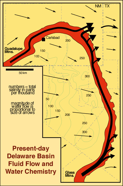
© Peter A. Scholle, 1999
The basin facies is typified by calcite and very subordinate quartz cementation of sandstones as well as compaction of sandstone, siltstone, shale, and carbonate beds. Porosity in the finer-grained basinal sandstones can be quite high (up to 27 percent; Williamson, 1977, p. 414) with corresponding permeabilities in the tens to hundreds of millidarcies.
Telogenetic (uplift-stage) alteration has substantially affected the region. Evaporite minerals that formed as primary precipitates or diagenetic phases were extensively hydrated, replaced, or leached during uplift, both at substantial depth and at the surface (Scholle et al., 1992). Thus, calcite and silica cements found in many environments are actually evaporite replacements and much of what one sees as porosity in surface outcrops may once have been evaporite-plugged in the subsurface.
Recent Models
The Permian depositional and diagenetic patterns described here can be matched quite closely in some modern settings. The basinal oceanographic conditions and the topographic configurations can be modeled in the Mediterranean, the Black Sea, and the Bahamas-Florida area. The restricted circulation and partially euxinic conditions can be found, to some degree, in the Red Sea, Mediterranean, and Black Sea during the Tertiary or Quaternary. The deep, relatively elongate, structurally controlled basins surrounded by steep, reefal escarpments bordering isolated platform areas, which are seen throughout the Permian basin, are best modeled in the Bahamas (Ball et al., 1969). Likewise, the Permian facies suite of fore-reef debris, reef, back-reef rubble, near-back-reef skeletal sands and muds, islands, restricted lagoons, and finally supratidal deposits is remarkably similar to the general facies spectrum found in the Florida Keys-Florida Bay area (Ginsburg, 1964; Purdy, 1963). Yet climatically and paleogeographically, the Permian of west Texas and New Mexico was much more like the arid, continent-interior southwestern margin of the Persian Gulf than the high-rainfall, ocean-margin region of south Florida. Thus, the lagoons and sabkhas of the Trucial Coast of the Persian Gulf provide an excellent analog for the far-back-reef areas of the Permian during highstand intervals (Kendall, 1969; Shinn, 1983).
It is clear, then, that no single area today provides a full analog for the Permian basin. Yet if we combine the climatic factors of the Persian Gulf with the tectonic-sedimentologic patterns of the Florida-Bahamas region and the hydrographic factors of the Mediterranean-Black-Sea-Red Sea area we can very closely approximate the patterns seen in the Permian.
Oil & Gas Production
The Permian basin has had hydrocarbon production for nearly 60 years and is one of the most prolific petroleum provinces in North America. To date, "approximately 91.6 billion barrels of oil-in-place and about 3 trillion cu m (106.2 trillion cu ft) of dissolved/associated and non-associated gas-in-place have been discovered in the Permian basin" (Dolton et al., 1979, p. 1). Production from the Permian basin extends from the Cambrian (Wilberns Fm.) to the Cretaceous (thin carbonate units) although production from units younger than Permian is negligible. Paleozoic reservoirs produce oil from depths of less than 150 m (500 ft) to greater than 4,250 m (14,000 ft) and also produce gas from depths of less than 150 m (500 ft) to greater than 6,400 m (21,000 ft) (Dolton et al., 1979). The Permian section is mainly oil productive with greater than 65 billion barrels of oil-in-place (71 percent of the total discovered in the Permian basin) having been discovered to date (in 2,188 pools). Non-associated gas production, on the other hand, comes predominantly from pre-Mississippian strata. Permian units contain only about 0.18 trillion cu m (6.3 trillion cu ft) of non-associated gas-in-place (about 13 percent of the total for the Permian basin). However, Permian units contain 0.93 trillion cu m (32.7 trillion cu ft) of associated/dissolved gas-in-place (54 percent of the Permian basin total) (Dolton et al., 1979).
The predominance of oil production from Permian units is clearly related to their relatively shallow burial in this region where virtually all Permian strata are found at present-day burial depths of less than 4,600 m (15,000 ft). Furthermore, virtually all production from Permian rocks comes from units at less than 3,000 m (10,000 ft) burial depths; most of it from less than 1,500 m (5,000 ft) depths (Dolton et al., 1979).
"The four provincial series of the Permian do not contain hydrocarbons in equal amounts. The largely evaporitic Ochoan rocks have accounted for only about 6 million bbls of discovered oil in-place, less than 0.01 percent of the Permian's 65 billion bbls" — (Dolton, et al., 1979, p. 24).
By contrast, the Guadalupian has accounted for 67 percent of all Permian oil found and 62 percent of all Permian gas. The Leonardian follows with 28 percent of the oil and 32 percent of the gas. The Wolfcampian contains 5 percent of the oil and 10 percent of the total Permian gas. These amounts are directly related to the progressive development of reefs and back-reef lagoons beginning in the Wolfcampian, increasing in the Leonardian, and culminating in the development of the Capitan reef complex in the Guadalupian.
Hydrocarbon traps in Permian rocks are largely a combination of stratigraphic and structural types, although each type does occur alone. The intricate stratigraphic interfingering of lithologies responsible for trapping much of the Permian oil has resulted largely from the constantly shifting sedimentary environments. In particular, the filling of the Midland basin during the early Guadalupian (by Grayburg time) meant that oil fields on the Midland basin side of the Central Basin Platform produce mainly from San Andres-Grayburg or older reservoirs (Ward et al., 1986). Continued carbonate sedimentation in the Delaware basin through the end of the Guadalupian resulted in the fact that oil fields on the west side of the Central Basin Platform produce largely from post-San Andres reservoirs (Figs. below).
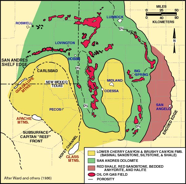
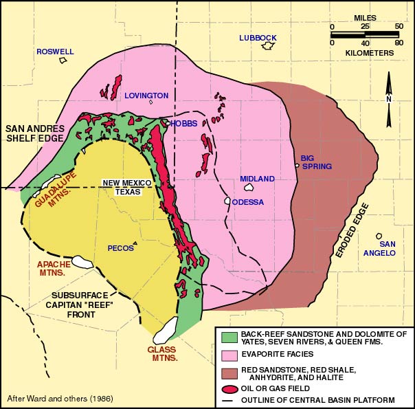
Primary sealing mechanisms in all units are porosity and permeability barriers of carbonate, evaporite or shale, particularly up-dip transitions from porous limestones or dolomites to anhydrite plugged dolomites (Ward et al., 1986). Thus, maps showing facies distribution versus known oil fields (Figs. 15 and 16) show a remarkably close correlation between them (Ward et al., 1986). Production is typically maximized in the near-back-reef or grainstone margin facies which underwent neither the marine cementation of the reefs nor the evaporite plugging of the farther back-reef strata. A roughly 10 km wide porosity-permeability fairway thus exists which contains most of the oil fields and closely parallels the outlines of basin configurations. About 40 percent of these (Permian) reservoirs are limestone, 29 percent are dolomite and 29 percent are sandstone. Porosities range from 1.5 to 25 percent and reservoir permeabilities from 0.02 to 200 millidarcies.
Recovery factors range from a low of 7.6 percent to a high of 47.5 percent. The fractured siltstone Spraberry reservoir of the Midland basin has a very low recovery factor, although the volume of oil in-place is the largest of any single Permian pool. The average recovery factor for the Permian System is 25 percent." (Dolton et al., 1979, p. 24).
Production totals for each producing stratigraphic unit are given in Table 3, along with a grand total for all these strata in the Permian basin region. Only units which will be seen on this field trip have been included in the table. Extensive production from age-equivalent but differently named units from the Central Basin Platform, Midland basin, and Eastern Shelf have not been listed. Data for this table was supplied by the Petroleum Data System, University of Oklahoma, Norman, Oklahoma.
Even a cursory examination of Table 3 will show that there is no production from the Capitan, Victorio Peak, or Goat Seep reef or fore-reef facies which were tightly cemented at the sea floor shortly after deposition. The vast bulk of production (greater than 90 percent) is from primary or early diagenetic secondary porosity in back reef dolomites, limestones and sandstones of the Tansill, Yates, Seven Rivers, Queen, and Grayburg Formations or the open shelf facies of the San Andres Limestone. A second, much smaller, peak of production comes from channel sandstones of the Delaware Mountain Group (particularly in the Bell Canyon Fm.) and basinal limestones of the Bell Canyon Fm. or Bone Spring Limestone. More significant oil reserves in basinal sandstones are found in the Midland basin. There, the Spraberry Fm. has more than 8 billion barrels of oil-in-place. However, recovery factors of less than 10 percent indicate ultimately recoverable reserves of about 534,000,000 barrels of oil.
Individual channels in the "Ramsey Interval" near the top of the Bell Canyon Fm. are up to 30 m (100 ft) thick, 0.4 to 6.5 km (1/4 to 4 mi) wide, and 80 km (50 mi) in length (Williamson, 1977; Williamson, 1979). These channels have a very pronounced regional trend (NE-SW for the "Ramsey") which strongly controls the shape and distribution of basinal oil fields.
In this setting, then, back-reef environments account for greater than 90 percent of all hydrocarbon production with basinal sediments accounting for the rest. Reef and fore-reef facies are totally non-productive. Clearly, penecontemporaneous and early burial diagenesis played a major role in controlling the distribution of reservoirs. Evaporite formation and dissolution, synsedimentary dolomitization, early vadose and phreatic leaching and cementation, coupled with probable early oil migration from rapidly deposited and buried, overpressured source rocks in the basins, led to outstanding reservoir characteristics on the shelf. Early submarine cementation obliterated reservoirs on the shelf edge and slope long before oil migration. Finally, some basinal reservoirs may have been preserved from compactional porosity loss by overpressuring beneath 200-1,200 m (2,000-4,000 ft) of rapidly deposited evaporites.
The source for most of this Permian oil is presumably from the euxinic, relatively organic carbon-rich, basinal sediments such as the Bone Spring Limestone and some intervals within the Delaware Mountain Group. Although these units generally have present-day organic carbon contents of less than 1 percent (King, 1948; Gawloski, 1987; Barker and Pawlewicz, 1987; Palacas, oral commun., 1978), their carbonate composition, great thickness, and intervening sandy, permeable zones may have meant that they could act as very efficient source rocks. Oil reservoired in the basinal facies, then, has probably migrated only a short distance from source to reservoir. Much of the oil in the back-reef sections, however, presumably moved up-section or laterally through fractured reef sediments to get from source to reservoir. The fracturing of the reef was essentially contemporaneous with deposition (because of compaction of the thick, underlying reef talus) and thus, even syndepositional reef cementation probably did not significantly retard fluid movement. Indeed, even today, the tightly cemented reef zone has the highest permeability of any of the Guadalupian bank-to-basin facies (Motts, 1968).
The abundant up-dip and overlying evaporite seals help to explain why, although the Permian basin is a source-rock-poor, it has one of the highest retention rates for generated hydrocarbons of any basin in the world. Although it is the largest petroleum province in North America, present-day oil seeps are quite scarce in this region.
Detailed discussion of individual oil fields is beyond the scope of this guide, but the "Atlas of Major Texas Oil Reservoirs" (Galloway et al., 1983) provides a wealth of information on area fields. Informative oil field summaries are also provided in Anonymous (1982) and Bebout and Harris (1986)
Current estimates of the volume of undiscovered hydrocarbons in-place for Permian rocks of the Permian basin are that "at the 95 and 5 percent probabilities, 1.0 to 6.0 billion bbls of oil in-place (1.5 to 9.2 percent of the discovered Permian crude oil) remain undiscovered, while 0.7 to 4.1 trillion cu ft of dissolved/associated gas in-place (2.2 to 12.4 percent of the discovered dissolved/associated gas) remain undiscovered. Finally, 0.2 to 0.6 trillion cu ft of non-associated gas in-place (3 to 21 percent of the discovered non-associated gas) remain undiscovered. Most of these undiscovered in-place hydrocarbons occur above 10,000 ft (Dolton et al., 1979, p. 47).
"These undiscovered amounts will probably occur in circumstances similar to known fields and pools with respect to reservoir characteristics, seals, source beds, and nature of the hydrocarbons. Traps will probably be predominantly stratigraphic. The undiscovered deposits are likely to be distributed in undrilled areas surrounded by or flanking known production. Such flanking areas are in the western part of the Northwestern Shelf, the western areas of the Delaware basin, and the southern and western parts of the Val Verde basin." (Dolton et al., 1979, p. 47).
Studies have shown that "undiscovered pool sizes are small; only at the 5 percent probability is there a chance of occurrence of an oil pool of 16 million bbls or larger, or a non-associated gas pool of 24 billion cu ft or larger." (Dolton et al., 1979, p. 47).
Concluding Notes
For further general discussions of Permian basin depositional and diagenetic facies patterns the papers by King (1948), Newell et al. (1953), Hayes (1964), Cys et al. (1977), and Ward et al., (1986) are recommended. Other, more specific papers, can be found in the provided extensive bibliography on the Permian basin region. Discussions of the specific details of facies patterns and diagenesis are also presented in the roadlog sections.


