


Virtual Geologic Field Trips to the Permian Reef Complex, Guadalupe and Delaware Mountains, New Mexico & West Texas
We are a research and service division of:
Overview
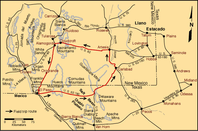
The roadlogs in this guide owe much to previous guidebooks (Nelson and Haigh, 1958; Anonymous, 1960, 1962, 1964, and 1969; Dunham, 1972; Pray, 1975; and Pray and Esteban, 1977). However, this guide has extensive additional commentary on many localities and is organized differently from previous guidebooks. All roadlogs are based on continuous routes with side trips being presented as separate, supplementary logs. Thus, the trip from El Paso to Carlsbad is logged as a continuous route with the excursions to McKittrick Canyon, Walnut Canyon, and Dark Canyon-Rocky Arroyo being listed as separately logged routes. This adds complexity to a bus tour but makes the logs much easier to use on car trips.
© Peter A. Scholle, 1999
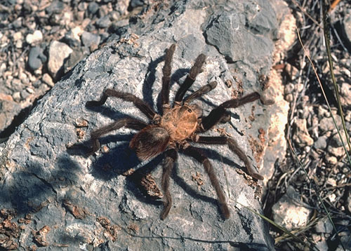
Please make SAFETY! your number one priority. We are going to be driving on back roads and will be a long way from medical attention. There are hospitals, emergency rooms and doctors in El Paso, Carlsbad and Alamogordo but we may be hours away from these facilities when we visit remote outcrops. This area has many hazards in addition to the "normal" geologic problems of loose boulders and sharp rocks. Cactus of many types, scorpions, and rattlesnakes are all common to the region and you must remain cautious and aware of these dangers at all times. We do carry a small first aid kit with us and thus can help, at least with minor "emergencies."
© Peter A. Scholle, 1999
Much of the trip is in national parks so in addition to watching out for wildlife, you must not harm it. A wide detour around hazards will prove to be the best strategy in almost all cases. Sample collection requires a research permit, so leave your hammers in the car while in national parks, but do bring your camera.
Index of Available Detailed Field Trip Locality Descriptions
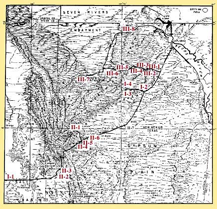
Day 1 - El Paso to Carlsbad
- Stop I-1 (View of western Escarpment)
- Optional Stop I-1a (Salt Flat salina)
- Optional Stop I-1b (South end of Guadalupe Mountains)
- Stop I-2 (Capitan reef, mouth of Walnut Canyon)
- Stop I-3 (Carlsbad Caverns)
- Stop I-4 (Yates-Tansill tepee/pisolite facies)
Day 2 - Carlsbad to southern Guadalupes
- Stop II-1 (Capitan forereef, McKittrick Canyon)
- Stop II-2 (Bone Spring Ls.)
- Stop II-3 (Brushy Canyon Fm. channel)
- Optional Stop II-3a (Brushy Canyon/Cherry Canyon contact)
- Optional Stop II-3b (Lower Cherry Canyon sandstone)
- Stop II-4 (Rader slide, Bell Canyon Fm.)
- Stop II-5 (Bell Canyon sandstone/siltstone)
- Stop II-6 (Lamar Limestone, Bell Canyon Fm.)
- Stop II-7 (Castile evaporites)
Day 3 - Carlsbad-Sitting Bull Falls-Rocky Arroyo
- Stop III-1 (Capitan/Tansill Mouth of Dark Canyon)
- Stop III-2 (Tansill grainstone/island facies, Dark Canyon)
- Stop III-3 (Tansill-Yates contact, Dark Canyon)
- Optional Stop III-3a (Yates tepees, Dark Canyon)
- Stop III-4 (Yates-Seven Rivers evaporitic mudstones, Dark Canyon)
- Optional Stop III-5 (Seven Rivers redbeds/dolomites, Dark Canyon)
- Stop III-6 (Seven Rivers bedded evaporites, Dark Canyon)
- Stop III-7 (Last Chance Canyon)
- Stop III-8 (Sitting Bull Falls)
- Optional Stop III-8a (Seven Rivers evaporites/red beds, Rocky Arroyo)
- Stop III-9 (Queen/Seven Rivers contact, Rocky Arroyo)
- Optional Stop III-9a (Seven Rivers dolomite cycles, Rocky Arroyo)