


GM-1 — Geologic map of Hillsboro Peak Thirty-minute Quadrangle, New Mexico
We are a research and service division of:
By Frederick J. Kuellmer, 1959, scale 1:126,720.
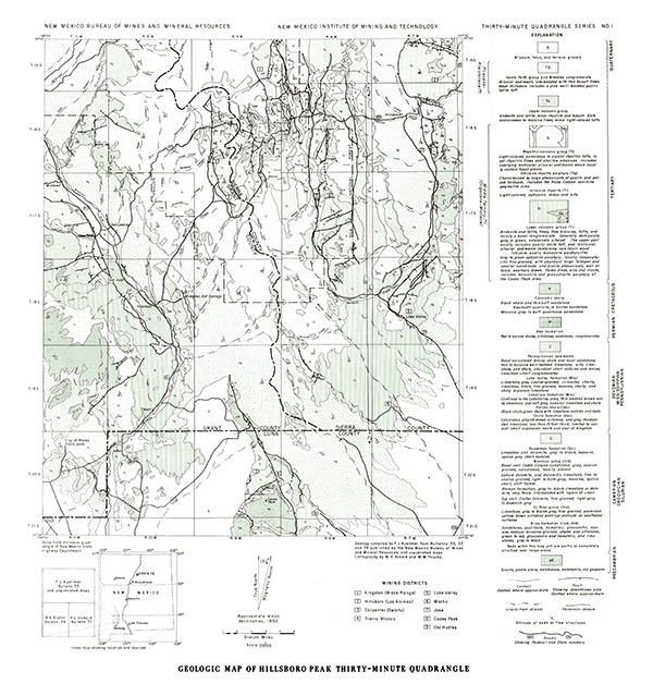
This map extends from City of Rocks State Park to northeast of Hillboro, New Mexico. The rocks exposed in this area include Precambrian basement, a significant Paleozoic section, Cretaceous sediments, and extensive Tertiary volcanic an intrusive rocks. The region surrounding the towns of Hillsboro, Kingston, and Lake Valley has a long history of mining and mineral exploration. Source data for this map include Bulletins 33, 37, and 38.
Related 30-minute geologic maps of this region include:
- GM-2 — Luera Spring
- GM-3 — Piñonville
- GM-5 — Datil
- GM-6 — Cañon Largo
- GM-10 — Mogollon
- GM-12 — Reserve
- GM-13 — Alum Mountain
- GM-14 — Las Cruces
- GM-15 — Virden
- GM-23 — Pelona
$10.00
Buy
Now
Also available as a free download.
Download
| File Name | Size | Last Modified |
|---|---|---|
| GM-1_map.pdf | 4.13 MB | 02/05/2021 02:47:01 PM |
| TIFF: | ||
| GM-1_map-pal.tif | 3.94 MB | 09/20/2018 01:04:36 PM |
| GM-1_map.tif | 28.03 MB | 09/20/2018 01:03:16 PM |