


GM-5 — Reconnaissance Geologic Map of Datil Thirty-minute Quadrangle
We are a research and service division of:
By Max E. Willard and David B. Givens, 1958, scale 1:126,720.
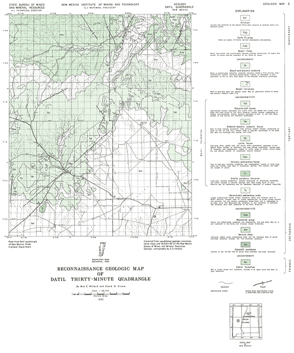
The southern portion of this map covers the San Agustin Plains with the rest covering the higlands in the vicinity of Datil New Mexico and farther north. The oldest rocks exposed are Triassic Chinle Formation (now Group), which is overlain by Cretaceous sediments, Tertiary sediments, volcaniclastics, and volcanic rocks and intruded by a Tertiary porphyry. The youngest volcanic rocks are Tertairy and Quaternary basalts.
Related 30-minute geologic maps of this region include:
- GM-1 — Hillsboro Peak
- GM-2 — Luera Spring
- GM-3 — Piñonville
- GM-6 — Cañon Largo
- GM-10 — Mogollon
- GM-12 — Reserve
- GM-13 — Alum Mountain
- GM-14 — Las Cruces
- GM-15 — Virden
- GM-23 — Pelona
$3.00
Buy
Now
Also available as a free download.
Download
| File Name | Size | Last Modified |
|---|---|---|
| GM-5_map.pdf | 4.97 MB | 02/05/2021 02:47:51 PM |
| TIFF: | ||
| GM-5_map-pal.tif | 4.79 MB | 09/20/2018 10:16:23 AM |
| GM-5_map.tif | 34.53 MB | 09/20/2018 10:14:46 AM |