


Geothermal Development Program — Technical Capabilities
We are a research and service division of:
Temperature gradient studies
Temperatures measured as a function of depth in a well are used to calculate geothermal gradient, which in turn is used to compute heat flow. Heat flow is a measure of the geothermal potential of an area. In addition, temperature-depth data are used to determine fluid entry, exit, and movement within a wellbore. This information can be used to identify multiple aquifers encountered by the wellbore. Furthermore, the temperature-depth data can be used to estimate the relative hydrologic head of the encountered aquifers.
Our temperature-logging equipment uses a thermistor attached to a wireline cable to measure resistance as a function of depth. Resistance is translated to temperature using a laboratory calibration. Resistance is recorded at 1-m depth intervals using a digital multimeter and a computer. We have two sensors: one is designed for fast response in air and the other is designed to measure resistance in water. The reproducibility of temperature measurements in the vadose zone below 25 m is 0.01°C. The sensor can measure temperatures up to 100°C and the cable is 1000 m long.
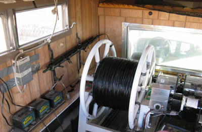
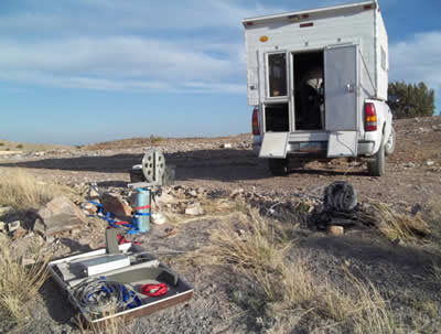
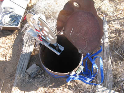
Spools of wireline cable are mounted in a camper on a pickup truck. The truck is driven to the well site and is backed up to within 20 to 40 feet of the well. A reel is attached to the well standpipe using straps and the cable is lowered down the well using a motor. Logging rate varies from 1 to 4 m/minute.
We have collected thermal gradient data in the Lake Valley-Hillsboro area, Truth or Consequences, Santa Fe, Taos, near Socorro, and near Hatch during the last two years. Our group was in charge of the geologic mapping and seismic data interpretation components of the Jemez Pueblo geothermal project. We also assisted with the installation and maintenance of a seismic network at the Pueblo.
Geothermal database
Temperature-depth, thermal conductivity, bottom-hole temperature, drill-stem test, porosity, permeability, lithologic log, and water chemistry data have been compiled and entered into an Access database. Requests for geothermal data from a specific area can be sent to our Geothermal Program manager, Shari Kelley.