


Overview of Fresh and Brackish Water Quality - Albuquerque Basin
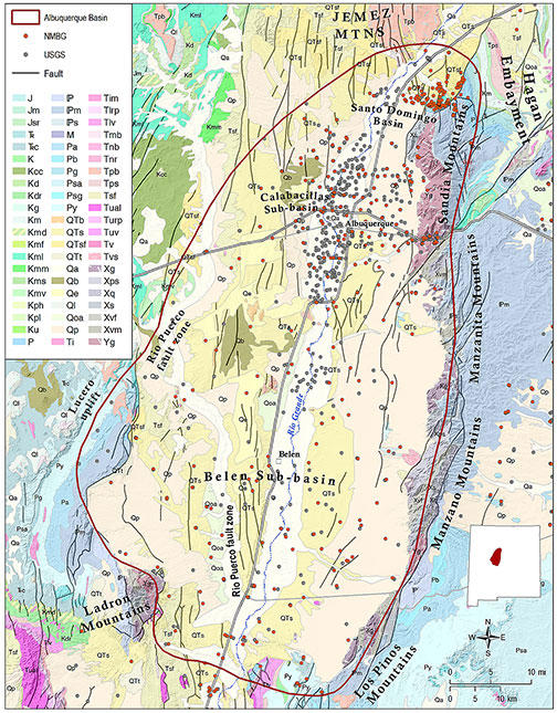
The Albuquerque Basin, also known as the Middle Rio Grande Basin (MRGB; Plummer et al., 2004), is defined by Thorn et al. (1993) to include the Santo Domingo Basin to the north, the Calabacillas and Belen Sub-Basins to the south, and the Hagan Embayment to the northeast. The Albuquerque Basin as thus defined is the second largest basin in the Rio Grande Rift, extending over more than 3000 square miles and containing over 14,000 feet of basin-fill deposits. The basin is bounded to the north by the Jemez Mountains, and to the east by the Sandia, Manzanita, Manzano and Los Piños Mountains. The western margin of the basin is defined by the Ladron Mountains, the Lucero and Nacimiento uplifts, and the Rio Puerco fault zone, a northeast-trending fault belt that separates the Albuquerque Basin from the Colorado Plateau (Plummer et al., 2004).
The hydrology, structure, and character of the basin fill in the Albuquerque Basin have been the subject of extensive previous investigations, including Kelley, 1977; Heywood, 1992; Hawley and Haase, 1992; Thorn et al., 1993; Connell et al., 1998; Grauch, 2001; Grauch et al., 2001; and Plummer et al., 2004. The conceptual model of the hydrogeologic framework of the Albuquerque Basin was substantially revised in the early 1990s based on investigations sponsored by the City of Albuquerque Public Works Department. Those investigations indicated that the zone of highly productive aquifer in the basin is much thinner and less extensive than had been previously reported (Hawley and Haase, 1992; Thorn et al., 1993).
The Santa Fe Group aquifer system is the principal source of water supply in the Albuquerque Basin. The system is made up of poorly-cemented sands and gravels of the Tertiary-Quaternary Santa Fe Group and overlying alluvial deposits associated with the Rio Grande and its tributaries. Mountain front recharge is one of the most important sources of recharge to the basin (Anderholm, 2001). Regional groundwater flow is to the south from the Albuquerque Basin to the Socorro Basin near San Acacia (Plummer et al., 2004).
The Santa Fe Group has been subdivided into lower, middle and upper hydrostratigraphic units and ranges in thickness from 2,400 feet near the basin margins to ~14,000 feet in the center of the basin. The most productive lithologies are axial channel deposits of the ancestral Rio Grande. Basin floor playa lake deposits of the lower part of the Santa Fe Group do not yield large quantities of water (Hawley and Haase, 1992; Thorn et al., 1993), and that water is assumed to be of poor quality. For this reason, only about the upper 2000 feet of the aquifer system is used for groundwater withdrawals (Bartolino and Cole, 2002).
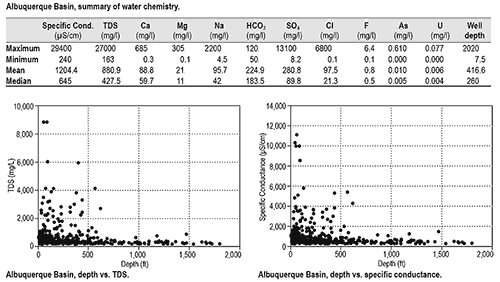
Water chemistry in the Albuquerque Basin has been extensively studied and is highly variable. Some chemical constituents have been shown to vary by several factors of ten, making it difficult to generalize about basin-wide water quality parameters (Bartolino and Cole, 2002). Plummer et al. (2004) identified 13 different hydrochemical zones based on analyses of water samples collected from 275 different wells and springs. However, because these samples were collected from existing production wells, they are not applicable to deeper zones within the Santa Fe Group aquifer system.
The data set for the Albuquerque Basin is exceptionally large, with 987 total records. Water quality in the basin is generally good, with mean and median values of TDS well below 1,000 mg/l. A small number of wells display unusually high mineral content. Those wells are for the most part located near the extreme southern and western margins of the basin. Plots of TDS and specific conductance vs. depth do not indicate the presence of deep sources of brackish water. As discussed above, these results in part reflect sampling bias because our data set relies on existing water supply wells that are not typically screened in brackish water intervals. Maximum well depth in our records is only 2,020 feet, indicating that the deeper portions of the Albuquerque Basin aquifer system remain unexplored.
Naturally-occurring arsenic is the constituent of greatest concern in groundwater of the Albuquerque Basin (Bartolino and Cole, 2002). Our records indicate mean values of arsenic in groundwater of 0.01 mg/l, which is the maximum contaminant level recommended by the EPA. The highest arsenic concentration was 0.61 mg/l, more than 60 times the recommended MCL, measured in a sample collected ~20 miles west of the Albuquerque South Valley.
This project is funded by the New Mexico Environment Department, Drinking Water Bureau, under Source Water Protection.
For more information:
see: Overview of Regional Brackish Water Assessments
or contact:
Lewis Land — Hydrogeologist, lland@nckri.org
References
- Land, Lewis, 2016, Overview of Fresh and Brackish Water Quality in New Mexico - Albuquerque Basin, Project Summary Sheet.
- Land, Lewis, 2016, Overview of Fresh and Brackish Water Quality in New Mexico, New Mexico Bureau of Geology Mineral Resources, Open-file Report, v. 0583, pp. 55.