


Permian Reef Complex Virtual Field Trip
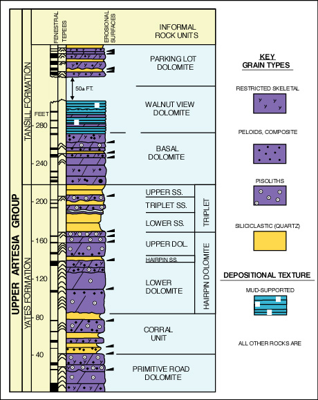
Stop I-4: Pisolite Facies at Top of Yates Fm.
We are a research and service division of:
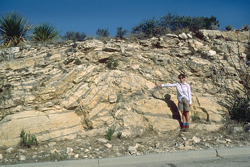
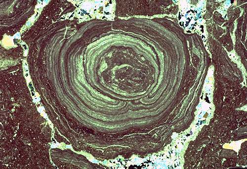
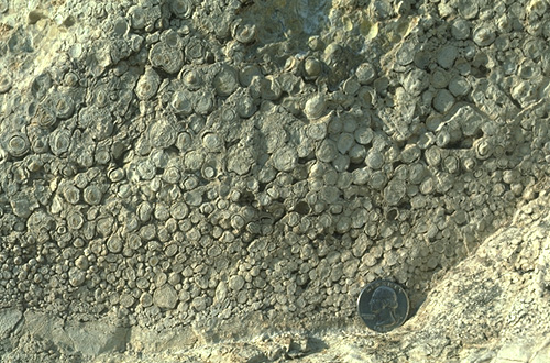
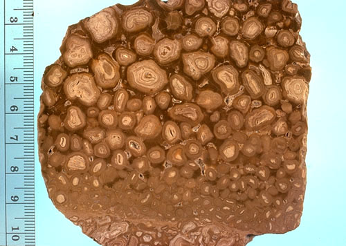
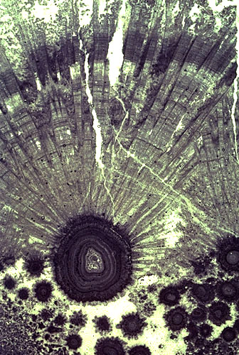
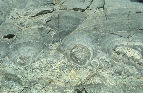
Outstanding exposures of pisolitic dolomites of the upper Yates Fm. (see Pray and Esteban, 1977; Dunham, 1972; Esteban and Pray, 1977). This locality illustrates numerous cycles of pisolitic, tepee-bearing sediments (termed "Walnutite cycles" by Pray and Esteban, 1977; see diagram below). Tepee structures can be seen both in this outcrop and in the distant canyon wall to the north (see photo). The main small-scale features to be seen at this outcrop are the abundant pisoliths which range from B-B-size to golf ball-size. They have concentric laminations of thin carbonate coatings around nuclei of fractured pisoliths or, rarely, marine fossils (see photo). The pisoliths, which have been completely replaced by aphanocrystalline dolomite, occur in cyclic beds, commonly with reverse grading (see photo). In some (but not most) cases, pisoliths have intergrown or interlocking textures (see photo).
© Peter A. Scholle, 1999
© Peter A. Scholle, 1999
© Peter A. Scholle, 1999
© Peter A. Scholle, 1999
There is considerable evidence to show that these pisoliths had original aragonite composition, now replaced by dolomite (see photo). They are associated with sheet cracks —broad bands of displacive, fibrous carbonate, presumably also originally aragonite (Loucks and Folk, 1976) but now dolomite or calcite (see photo). These displacive crusts are related to the origin of the tepee structures of this area for the tepees are expansion polygons formed by a volume increase of the associated sediments. This was most likely accomplished by in situ, near surface, displacive growth of aragonite and (or) evaporite minerals.
© Peter A. Scholle, 1999
© Peter A. Scholle, 1999
The origin of pisoliths and tepee structures in these sediments has been the subject of numerous studies and considerable controversy. Extensive discussions of these problems have been presented by Dunham (1972), Esteban and Pray (1977), Pray and Esteban (1977), and Handford et al. (1984) and so will be only briefly outlined here.
Basically there are three hypotheses: 1) the "all wet" model which proposes that the pisoliths were formed by organic (algal) or inorganic coating of grains in a shallow-water shelf setting with each grain acting as a free, clastic particle; 2) the "caliche" hypothesis which suggests that pisoliths formed in situ as part of cyclic, reverse graded, caliche profiles which formed by alteration of carbonate sediment brought into the area by storms or other episodic processes; and 3) salina "seepage" model which proposes that ocean water seepage through permeable barriers into sub-sealevel salinas can produce tepees and pisoliths by evaporation and precipitation. Advocates of any of these models can point to modern analogs (mainly from Persian Gulf, Red Sea, or Australian areas) with scattered, small-scale accumulations of aragonitic pisoliths in marginal marine, hypersaline settings. Yet nowhere have we discovered an analog which comes close to modeling the breadth and abundance of pisoliths that one sees in the Permian.
The differences of interpretation of these deposits, although important from the point of view of fully understanding the rocks, are not of great significance to the explorationist. There can be little argument that this facies must have stood close to a paleotopographic high-point in Guadalupian time. The persistence of this facies in space and time (it is present in Grayburg, Queen, Seven Rivers, Yates, and Tansill rocks), its consistent geometry (an elongate facies, parallel to the reef trend), and its equally consistent juxtaposition between open marine (grainstones with a high faunal diversity) and restricted (hypersaline mudstones and evaporites) environments indicate that the pisolite facies must either itself have been a major hydrographic barrier or it must have formed just landward of such a barrier. Nowhere in the world today are evaporitic mudstones and open marine, faunally diverse sediments in such close proximity without having an intervening barrier. It seems likely that to act as such a barrier, at least a narrow strip of land would have had to be subaerially exposed (except for tidal channels). This scenario would favor either the caliche or salina seep interpretations. Further support for the salina model may come from isopach studies of the thin sandstone/siltstone beds which are interspersed with the tepee-pisolith beds. Candelaria (1989) showed that these beds did not thin over the pisolite facies but did thin rapidly over the marine grainstones which lay just seaward of the pisolite facies. Although such a relationship may be due to reworking of shelf-margin sands by transgressive seas, it may also indicate depositional thinning over a topographic high in that area.
At this time, then, it seems most likely that the facies just seaward of the pisolites formed an elongate, irregular ridge of low-relief islands, tidal flats, and dunes (Fig.12) which allowed marine water seepage into the back barrier lagoon. Such seepage zones saw massive precipitation of aragonite cements and formation of pisoliths and in the modern Lake McLeod and Yorke Peninsula examples (Handford et al., 1984; Lock and Burne, 1986; Logan, 1987)
Finally, it is possible that a combination of processes could have been involved in the formation of pisoliths. A number of different types of pisoliths can be seen in the Permian strata. These range from the small, irregularly coated grains seen at Stop III-2 (and which almost certainly formed in a marine setting) to the larger, smoother, and more extensively encrusted grains present at this locality. Thus, a number of different origins can be envisioned for the various pisolith types.
The tepee structures and sheet cracks found in association with pisolitic sediments can also be interpreted as either marine or nonmarine. Displacive aragonite crusts and tepees have been noted in submarine cemented areas within the Persian Gulf itself as well as in coastal caliches and sabkha surfaces of the surrounding, subaerially-exposed coastlines (Kendall, 1969; Shinn, 1969; Warren, 1983).
ROADLOG ENDS. Return down-canyon to main El Paso-Carlsbad highway (U.S. 62-180).
Return to the Walnut Canyon Roadlog or the El Paso-Carlsbad Roadlog