Virtual Geologic Field Trips to the Permian Reef Complex, Guadalupe and Delaware Mountains, New Mexico & West Texas
— Geologic Road Log: El Paso TX – Carslbad, NM
Stops:
Introduction
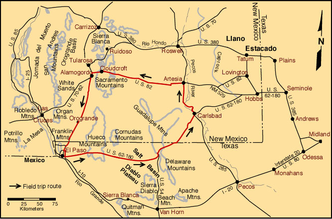
This guide to the geology along U.S. Highway 62-180 was put together for AAPG Field Seminars run from the 1980's through the mid-1990's. Some elements have been revised since then; others are in the process of being revised. So please accept the fact that not all parts of this log are fully up-to-date. The roadlog is written for a trip from El Paso to Carlsbad , but mileages are also provided for a trip in the other direction. The descriptions of the main field trip localities are in separate files but are easily accessed by clicking on the locality name. Likewise, side trips off U.S. 62-180 to McKittrick Canyon, Walnut Canyon-Carlsbad Caverns, and Dark Canyon-Sitting Bull Falls-Rocky Arroyo are in separate files (click on the names to go to those road logs). Citations to other publications are linked to two lists of references — one on Permian Basin literature and one dealing with other literature. Clicking on the citation name will take you to the appropriate listing. In the Permian Basin bibliography it will take you to the first listed citation of the primary author; you then need to scroll down to the desired reference. If the citation is in the more general (and much shorter) bibliography, clicking on the citation will take you to the list and you will have to scroll to both the author and the citation.
| Mileage | Location Description | ||
|---|---|---|---|
| Last Stop | From El Paso |
From Carlsbad | |
| 0.0 | 0.0 | 159.4 | Leave El Paso Airport on Airway Rd.; turn left (heading east on U. S. Highway 62 and 180 (Montana Avenue). Behind us (to the northwest) are the Franklin Mountains, a block faulted section of Precambrian through Paleozoic strata (Fig. 19) steeply tilted to the west. The sections there have been summarized in a number of articles and guidebooks (Cunningham and Cromwell, 1989; LeMone, 1988; LeMone and Lovejoy, 1976; Nelson and Haigh, 1958). Also see the description of the El Paso area and its geology at the end of the Alamogordo to El Paso roadlog in this guidebook. |
| 7.1 | 7.1 | 152.3 | Stabilized (vegetated) dunes of clastic terrigenous debris blown from the floor of the Hueco Bolson, the flat, intermontane basin we have been and are continuing to cross. The Hueco Bolson is one of the southernmost grabens of the Basin and Range Province and is bounded on the west by the Franklin Mountains and on the east by the Hueco and Sacramento ranges. To the north, near Orogrande (north of the Texas-New Mexico border), the Hueco Bolson is separated from the Tularosa basin (which has completely internal drainage) by a low ridge. The Hueco Bolson has external drainage along its southeastern side through the Rio Grande River valley. The average elevation of the Hueco Bolson is approximately 1,200 m (4,000 ft), and the basin averages 40 km (25 mi) in width and 130 km (80 mi) in length. "A recent (1967) U.S.G.S. seismic and gravity profile across the Hueco Bolson from the base of the Franklin Mountains to the base of the Hueco Mountains indicates a deep structural trough bounded on the west by a large normal fault. The maximum thickness of the Hueco Bolson fill in the center of this trough is calculated to be about 9,000 feet [2,750 m]." (McGlasson and Seewald, 1968). Details of the seismic line and supplementary gravity work were published by Mattick (1967). The bolson fill ranges in age from Miocene to Holocene; the Pleistocene deposits are particularly thick, with local accumulations of as much as 1,500 m (5,000 ft) of Pleistocene alluvial and lacustrine sediment (Strain, 1969). Surface sediments in the bolson belong mainly to the Pleistocene Fort Hancock and Camp Rice Fms. which are best exposed along the Rio Grande River. The bolson forms the main aquifer for the El Paso-Juarez area. This trapped water is mainly from Pleistocene pluvial cycles and is being depleted rapidly. |
| 1.5 | 8.6 | 150.8 | El Paso city limit. |
| 3.1 | 11.7 | 147.7 |
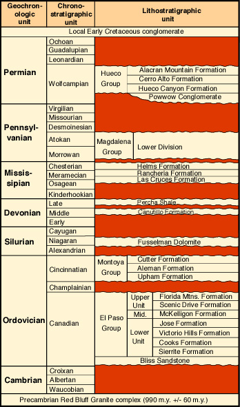
Junction with Texas FM Road 659 to Ysleta (to right) and start of two-lane section of U. S. Highway 62 and 180; continue straight ahead. The intensely block-faulted, low-relief (ca. 300-460 m; 1,000-1,500 ft) Hueco Mountains can be seen directly ahead. Precambrian to Tertiary igneous, metamorphic and sedimentary rocks are exposed in this range (see stratigraphic diagram). Cerro Alto, the highest peak, is a Tertiary syenite porphyry intrusive. The Permian (Wolfcampian to early Leonardian) section of the Hueco Mountains contains nearly 600 m (2,000 ft) of limestone and very subordinate shale. The pre-Permian sedimentary section consists of a lower interval of Cambrian to Mississippian strata (mainly limestones and dolomites) and an upper interval of Pennsylvanian limestones, shales, and subordinate sandstones. The upper and lower intervals each contain up to 600-1,200 m (2,000-4,000 ft) of section. The lower interval shows disconformable contacts typical of stable shelf sections, whereas the upper interval contains angular unconformities indicative of the increased tectonic activity and bank-to-basin differentiation of that time period. 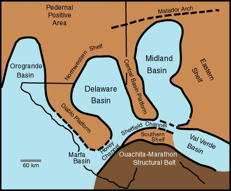
Throughout this trip, the bank-to-basin facies sequences we see will be related in one way or another to the initial, structurally controlled topographic variations generated during Pennsylvanian and Permian deformation. The folding and faulting of this period, part of the Ancestral Rockies movements, generally trends northwest-southeast. The Diablo Platform, Orogrande basin, Pedernal High, Northwest Shelf, and Delaware basin were among the many major physiographic features (see diagram) formed during this time interval. This primary structural relief was, in most cases, strongly modified by subsequent differential sedimentation. |
| 4.4 | 16.1 | 143.3 | Loose (unvegetated) dunes deposited by winds from the northwest which lose velocity and drop sand near the base of the Hueco Mountains. The hills on the right (largely covered by dunes) are made of Wolfcampian limestones of the Hueco Group. |
| 2.5 | 18.6 | 140.8 | Quarry in Hueco Group limestone on the right. The limestone here is about 97 percent pure CaCO3 and the quarry exposes a single, thin, fusulinid-rich bed about 3/4 of the distance up the rock face. The quarried carbonate is calcined and is sold as quick lime. |
| 0.4 | 19.0 | 140.4 | Lower part of Hueco Group is exposed in hill on right. The unconformable contact between the Hueco limestone and the underlying lower part of the Pennsylvanian Magdalena Limestone is exposed in the low knob at the base of the eastern slope of the hill. This unconformity is an indication of pre-Permian uplift and erosion on the Powwow anticline. |
| 0.8 | 19.8 | 139.6 | Exposures of the Mississippian Helms and Pennsylvanian Magdalena Formations in hills on left. |
| 0.6 | 20.4 | 139.0 | Quarry at 2:00 o'clock in Magdalena Limestone. The very pure (99.8 percent CaCO3) limestones in this quarry, as well as those from the quarry at mile 18.6, were formerly transported to El Paso where they were calcined to CaO (quick lime). |
| 0.3 | 20.7 | 138.7 | Junction with Texas SF Road 2775 to Hueco Tanks State Park; continue straight ahead. Mounds visible in the upper parts of nearby hills are phylloid algal and fusulinid buildups in Virgilian limestones (Pol, 1988a). These are smaller than, but otherwise similar to, buildups we will examine in the Sacramento Mountains. |
| 0.3 | 21.0 | 138.4 | Hills on left are capped by Magdalena Limestone. The southeast dips visible here are on the flank of the Powwow anticline. The Jones No. 1 Sorley well, drilled a few miles west on the crest of the Powwow anticline, encountered Precambrian granites at 662 m (2,172 ft) depth. Helms Peak (elevation 1,649 m; 5,409 ft) at 2:00 o'clock is capped by limestones of the Hueco Canyon Formation unconformably overlying middle Magdalena Limestone. |
| 0.7 | 21.7 | 137.7 | Entering Powwow Canyon. |
| 1.9 | 23.6 | 135.8 | Roadcut in middle Magdalena Limestone. |
| 0.5 | 24.1 | 135.3 | Roadcut in middle Magdalena Limestone. |
| 0.8 | 24.9 | 134.5 | Roadside park on left. The unconformity at the base of the Permian is clearly visible directly ahead. On the western side of the Hueco Mountains this unconformity cuts down to the Ordovician El Paso Limestone. In the outcrop directly ahead, the unconformity is between the Pennsylvanian Magdalena Limestone and the basal Hueco Group. |
| 0.4 | 25.3 | 134.1 | Roadcut in upper 40 m (130 ft) of Magdalena Limestone. |
| 0.3 | 25.6 | 133.8 |
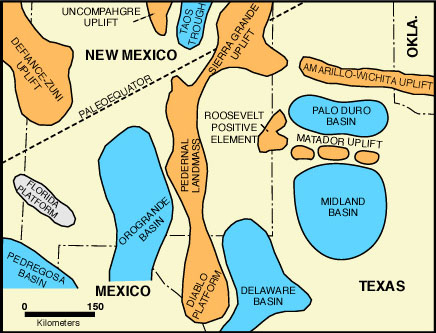
Early Permian time. Adapted from Pol (1982) and Candelaria (1988b). Roadcut in the basal part of the Permian Hueco Group (including the poorly exposed Powwow Conglomerate and the overlying upper member of the Hueco Canyon Formation). The Powwow Conglomerate varies locally in thickness but is about 10 m (30 ft) thick in this area. It contains red shales, siltstones, and chert- and limestone-pebble conglomerates. Another redbed interval (the Deer Mountain Shale) occurs near the top of the Hueco Group. These redbeds are considered to be the southern tongues of the thick, predominantly redbed Abo Formation and the clastic units of the Laborcita Formation which are seen in the Sacramento Mountains (Candelaria, 1988; Pol, 1988b). The Lower Permian paleogeography of the region is shown in the nearby diagram — this locality (as well as the ones we will examine in the Sacramento Mountains) lay just to the west of the Pedernal-Orogrande positive element and thus had extensive terrigenous influx. The uplift was greater to the north so that the non-marine, terrigenous components of the Lower Permian section increases significantly toward the north. Detailed field guides to the geology of the Hueco Mountains have been published recently (Meader-Roberts, 1983; Robichaud and Gallick, 1988) and should be consulted for further information. |
| 0.2 | 25.8 | 133.6 | Roadcut in Hueco Canyon Formation, mainly shelfal limestones containing scattered phylloid algal plates, fusulinid foraminifers, mollusks, and other shallow marine fauna with considerable micritic matrix. |
| 1.2 | 27.0 | 132.4 | Hueco Inn on left. Continued Hueco Group outcrops for next twelve miles. |
| 8.7 | 35.7 | 123.7 | Forty Mile Hill (elevation 1,654 m; 5,427 ft). Leaving Hueco Mountains; emerging onto Diablo Plateau. |
| 3.1 | 38.8 | 120.6 | Roadside rest area on left with view of numerous extrusive and intrusive igneous features to the north and northeast in the Cornudas Mountains. The central, high volcanic cone is San Antonio Peak (2,140 m; 7,020 ft). |
| 13.3 | 52.1 | 107.3 | Limestones of Hueco Group in roadcut. |
| 4.7 | 56.8 | 102.6 | Road on Lower Cretaceous Campagrande Formation. |
| 0.5 | 57.3 | 102.1 | Junction with Texas Ranch Road 2317; continue straight ahead. Molesworth Mesa, which lies to the south, is composed of Cretaceous Trinity and Fredricksburg sediments. |
| 1.9 | 59.2 | 100.2 | Mountains at 9:00 o'clock are the Sierra Tinaja Pinta, a breached laccolith. The anticlinal structure in the center is composed of Bone Spring Limestone and is flanked by sediments of the Yeso Formation. |
| 5.0 | 64.2 | 95.2 | Junction with Texas Ranch Road 1111; continue straight ahead. |
| 6.1 | 70.3 | 89.1 | The Antelope Hills, containing basal Cretaceous sandstones cut by a Tertiary sill, are visible at 3:00 o'clock. |
| 2.7 | 73.0 | 86.4 | Road is on Bone Spring Limestone. |
| 1.5 | 74.5 | 84.9 | Junction with Texas Farm Road 1437 to Dell City on left; continue straight ahead. Dell City is a farming community in the Salt Flat Bolson which has grown up as a consequence of the development of wells drawing Pleistocene(?) ground water from the bolson-fill. Rapid depletion of the water supply (use greatly exceeds recharge) and increasing soil salinities indicate a short or very expensive continued existence for agriculture in this region. For more details on the hydrology of the basin, see Nielson and Sharp (1985). |
| 0.1 | 74.6 | 84.8 | Road crosses basal Cretaceous sandstones and passes into Bone Spring Limestone. |
| 6.5 | 81.1 | 78.3 | Los Alamos Hills can be seen to the south of the highway in foreground. Leonardian to basal Guadalupian rocks are exposed here. |
| 1.0 | 82.1 | 77.3 | Junction with Texas FM Road 1576 to Dell City. Turn left for view stop. |
| 0.25 | 82.35 | 77.05 | STOP I-1. West face of Guadalupe and Delaware Mountains. Click on stop name to see locality description. When viewing is completed, turn around and return to U. S. Highway 62 and 180. |
| 0.25 | 82.6 | 76.8 | Turn left on U. S. Highway 62 and 180 to go towards Carlsbad or rigt is floowing log to El Paso. |
| 0.8 | 83.4 | 76.0 | Crossing northern extension of East Diablo fault with the Salt Flat basin down-thrown on the eastern side. |
| 2.7 | 86.1 | 73.3 | Historical marker near site of former spring-fed oasis (Crow Springs) and a relay station of the Butterfield Overland Stage. The Butterfield Mail route (see cover illustration) was established in 1858 and passed through the area of Guadalupe Pass (Pine Springs). This was part of a trail which extended from Memphis and St. Louis to San Francisco (Adams, 1988). This particular part of the route lasted only about one year, however, before the route was shifted southward to the approximate track of the present Interstate 10 through the Davis Mountains. The entire operation of the Butterfield Overland Mail was halted by confederate action in the Civil War. While it operated, however, it provided remarkably fast (25 day) and reliable service over its nearly 4,500 km (2,800 mi) route (Adams, 1988). The 180 km/day (120 miles/day) travel rate was especially remarkable considering the hostile, rugged country traversed and the fact that only 3 cities (El Paso, Tucson, and Los Angeles) lay on the route. Fares were rather high ($200 westbound; $100 eastbound) but the service was fully booked throughout its short history. |
| 1.5 | 87.6 | 71.8 | OPTIONAL STOP I-1a. Center of Salt Flat graben and playa (see photo). 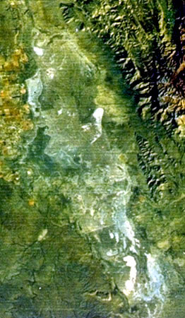
This major graben, the easternmost of the Basin and Range province, formed in middle to late Tertiary time. The basin is about 100 km (60 mi) long and 16 km (10 mi) wide and has been the site of continuous alluvial, fluvial, and lacustrine sedimentation since the middle Tertiary. The sediment thickness in the basin is probably a few thousand meters. Basin margin sediments include coarse gravels and sands alternating with clays derived from the weathering of the adjacent mountains (especially the Guadalupe and Sierra Diablo ranges). Because there is no natural outlet for the basin, all drainage is internal and sediments become finer-grained toward the basin center. Several important aquifers are present within the basin fill and these are currently being exploited for irrigation in areas such as Dell City to the northwest. Modern saline playas occur in the Salt Flat area of Texas and the Crow Flat area of New Mexico and Texas, in the topographically lowest parts of the basin (elevations about 1,100 m; 3,630 ft). These playas form in a region of low rainfall (about 23 or 25 cm/yr average; 9 or 10 in/yr) and high evaporation (about 200 cm/yr; 80 in/yr)(Dunham, 1972). Thus, groundwater, which stands at a level near the playa surface, is drawn upward and is evaporated. These groundwaters have percolated through nearby evaporite-bearing Permian strata and thus are already charged with considerable dissolved solids which are further evaporatively concentrated, leading to very elevated salinities (exceeding 250-300 ppt). These high salinities greatly restrict vegetation and allow eolian deflation of the rather fine-grained playa precipitates. Pits excavated in the playa sediments reveal firm but not hard, fine-grained, laminated, non-fossiliferous lacustrine materials. Modern gypsum and halite are the dominant evaporite minerals but calcite, aragonite, and dolomite have also been found in the playa sediments either as primary or secondary minerals (see Friedman, 1966; and Dunham, 1972, for further details). C14 age dating and geological mapping of basinal units indicates that much of the sediment found at the surface today may be relict from a larger Pleistocene pluvial lake (King, 1948; Dunham, 1972). Dark layers in the sediment are extremely organic-rich, averaging 51 percent organic matter (Hussain, et al., 1988; Hussain and Warren, 1985). Eolian deflation has piled up some of the primary and secondary minerals from this sediment (mainly gypsum) as dunes along the margins of the playa area. Halite has been mined from the surface of the playa in areas to the south of the road although halite is not preserved to any extensive degree in buried sediments. This salt was a most highly valued commodity in the 1880's and was used for food preservation, final curing of hides, and other purposes. It was such a valuable substance that it was hauled by mule- and ox-drawn vehicles for many hundreds of miles over the southwest trail to Fort Quitman, then to San Elizaro, Franklin (now El Paso), Paso del Norte (now Juarez), and on to Chihuahua City. Disputes between Mexican and American mining interests in the area led to the El Paso Salt War of 1877. The conflict culminated in the battle of San Elizaro (then the county seat of El Paso County). Improved(?) food preservation techniques and more economical sources of salt have eliminated the relatively small-scale mining in this area although some salt was still "mined" into the 1950's. On the south side of the road the Paso-Tex oil pipeline can be seen sitting on trestles; on the north side of the road the El Paso Natural Gas pipeline to the Pacific Coast is buried beneath playa sediments. |
| 0.8 | 88.4 | 71.0 | Gypsum-bearing dunes are derived from deflation of the nearby playa surface. These gypsum dunes extend for long distances north and south of the road and constitute one of the larger accumulations of reworked gypsum in the U.S. |
| 2.2 | 90.6 | 68.8 | Eastern edge of the Salt Flat basin. |
| 0.8 | 91.4 | 68.0 | Folded and downfaulted blocks of Upper Permian on the left. |
| 1.2 | 92.6 | 66.8 | Beacon Hill on the left is composed of Capitan Limestone with Rader Limestone at the base of the hill. This is the southern end of the Patterson Hills which consist of complexly faulted and folded Upper Permian limestones. Farther north are the Brokeoff Mountains. |
| 0.5 | 93.1 | 66.3 | El Paso Natural Gas Co. Guadalupe Compressor station on the left. |
| 0.3 | 93.4 | 66.0 | Roadcut in Bell Canyon Formation. |
| 0.4 | 93.8 | 65.6 | Roadcut in Bell Canyon Formation. |
| 0.3 | 94.1 | 65.0 | Roadcut in Cherry Canyon Formation; note greenish bentonite beds. |
| 1.0 | 95.1 | 64.3 | Roadcut in downfaulted Bell Canyon Formation. |
| 0.8 | 95.9 | 63.5 | Roadcut in Cherry Canyon Formation. The Patterson Hills to the left are capped by Capitan-age limestone. |
| 0.6 | 96.5 | 62.9 | Roadcut in Cherry Canyon Formation exposing contact with Brushy Canyon Formation at east end of outcrop. |
| 0.5 | 97.0 | 62.4 | Junction with Texas Highway 54 to Van Horn on right. Keep left for Carlsbad. |
| 0.3 | 97.3 | 62.1 | OPTIONAL STOP I-1b. Southern tip of the Guadalupe Mountains. 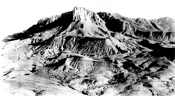
The excellent view of the south end of the Guadalupe Mountains here shows the clear relations between reef, fore-reef, and basinal facies (see diagram below and photograph). Ahead and to the right, is the escarpment of the Delaware Mountains composed of Brushy Canyon and Cherry Canyon basinal sediments mainly sandstones and siltstones). The Delaware Mountain ridge is capped by the resistant Getaway Limestone which is exposed near the radar station visible at the top of the cliff. The Getaway Limestone Member occurs at a level about 30-60 m (100-200 ft) above the base of the Cherry Canyon Formation and, in this area, is a very fossiliferous, gray to black, turbiditic limestone (Harris and Wiggins, 1985). Note the abundance of lenticular, channelized bedding in the Brushy Canyon and basal Cherry Canyon sections exposed in the Delaware Mountains escarpment. This entire sequence was apparently deposited in water depths of at least a few hundred meters by a combination of density currents, mass flows, localized slumps, and perhaps even contour currents. Much of the darker material visible in the cliff face represents relatively fine-grained overbank or non-channelized flows. The lighter-colored, lenticular sediments are coarser-grained, massive, channel-fill sandstones. Finally, at the very base of the escarpment, a dark ledge of the basinal Bone Spring Limestone is exposed. 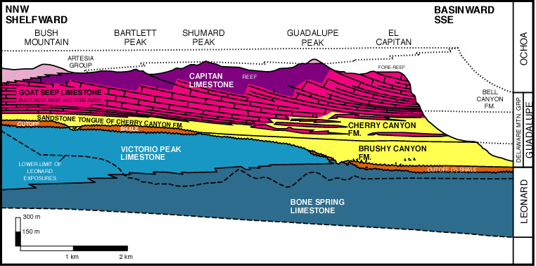
To the left we can see the great mass of Capitan Fm. carbonate which forms the upper part of El Capitan. The Capitan strata in this face are virtually completely dolomitized (which accounts for this prominent erosional remnant) and represent a forereef rubble facies which is time equivalent to the Hegler, Pinery, and Rader Members of the Bell Canyon Formation. Below the massive (300-460 m; 1,000-1,500 ft thick) carbonate, gently sloping deposits of the Cherry Canyon Formation are evident. "The three distinctly visible ledges represent in ascending order the three basinal limestone tongues of this formation named Getaway, South Wells, and Manzanita" (K. W. Klement, in Anonymous, 1969, p. 18). The rest of the lower slopes of El Capitan are composed of Brushy Canyon Formation. The lateral flattening of dips from El Capitan to the Delaware Mountains is not a result of deformation, but rather represents a primary facies transition from reef to basin. The thick, steeply dipping, rubbly limestones of the fore-reef facies thin rapidly toward the basin so that 30 or more meters (100+ feet) of reef limestone may be time equivalent to a 0.3-2 m (1-6 ft) thick limestone in the center of the Delaware basin. The color change from the light colored, largely oxidized beds of the reef and fore-reef to the dark colored, organic carbon-rich, dysoxic to anoxic basinal facies can also be seen in these exposures. It should be pointed out, again, that the great thicknesses of basinal sandstones (about 1,070 m or 3,500 ft of Delaware Mountain Group), although derived from the shelf, have only thin equivalents in the back-reef facies and are virtually absent in the reef itself. In part, this may reflect the fact that much of the basinal sandstone was apparently transported from the north and northeast. The sands moved across the Northwest Shelf as well as the Central Basin Platform (the Midland basin was filled by then) from sources in the Pedernal Massif and the Arbuckle and Wichita uplifts (Berg, 1979; Bozanich, 1979; Hull, 1957; Watson, 1979). Thus, much of the sand influx may have been funneled through gaps in the reef in areas not currently exposed in outcrop. There is evidence, however, from submarine channel orientations, other current direction indicators, stratigraphic relations of basinal sandstones and fore-reef carbonate rocks, and the presence in outcrop of numerous, if thin, back-reef and fore-reef sandstone beds, that some sand also moved across the northwestern part of the basin margin along which we are now standing. Thus, in all probability, another explanation must be sought for the inverse relationship of thick carbonate and thin sandstone units on the shelf and thin carbonate and thick sandstone units in the basin. As discussed in the introduction, Silver and Todd (1969) and Meissner (1972) proposed concepts of reciprocal sedimentation to explain these observations. This model suggests that the carbonate sediments were deposited during high eustatic sea level stands. During these times , the shelf areas had massive carbonate buildups which maintained the shelf edge at or near sea level and terrigenous sands were largely trapped in back-reef lagoons or in continental basins and dune fields. The evaporitic conditions led to the formation of saline bottom-waters and a density-stratified basinal water column. This, in turn, led to largely euxinic, sediment starved conditions on the floor of the basin. During lowered sea level stands, on the other hand, eolian and fluvial(?) transport of large volumes of well-sorted arkosic sand to the shelf edge provided a massive supply of unconsolidated material on the upper slope. From there the sands were reworked into the basin by a variety of gravitationally driven current mechanisms. Subsequent transgression in the next cycle removed virtually all traces of sand from the tightly cemented shelf-edge limestones. |
| 0.7 | 98.0 | 61.4 | Dirt road with locked gate on north side of highway leads to west face of Guadalupe Mountains (Williams Ranch). For field guides to this area, see Pray (1988b). Keys must be obtained from the National Park Headquarters and this unimproved road requires high clearance, preferably four-wheel drive vehicles. |
| 0.7 | 98.7 | 60.7 | STOP II-2. Bone Spring Limestone outcrop. Click on stop name to see locality description. |
| 0.4 | 99.1 | 60.3 |
Roadcut in Brushy Canyon sandstone. |
| 0.5 | 99.6 | 59.8 |

© Peter A. Scholle, 1999
Well exposed, lenticular, sandstone channel deposits of the Brushy Canyon Formation are visible in the distance on both the left and right sides (see photo). |
| 1.6 | 101.2 | 58.2 | STOP II-3. Brushy Canyon Formation basinal channel sandstone outcrop. Click on stop name to see locality description. BE CAREFUL TRAFFIC IS ESPECIALLY HAZARDOUS AT THIS OUTCROP! |
| 0.5 | 101.7 | 57.7 | 
© Peter A. Scholle, 1999
Roadside rest areas on left and right. Excellent views of El Capitan (see photo) and the Delaware Mountain escarpment. Again, the bank-to-basin transitions of the Capitan Limestone and its equivalents are well shown. |
| 0.7 | 102.4 | 57.0 | Roadcuts in sandstones and siltstones of the Brushy Canyon Formation. |
| 0.4 | 102.8 | 56.6 | OPTIONAL STOP II-3a. View along the Delaware Mountains escarpment on the right. Outcrops on the left consist of upper Brushy Canyon Formation sandstones with oriented fusulinid Foraminifera that were reworked into the Delaware basin from the adjacent Northwest Shelf. Several of the beds in this interval show distinct grading and well-defined flute casts on their bases, both evidence of probable turbidity current transportation. In thin section one sees compaction of the sandstones, some quartz overgrowth cement (minor), calcite cementation (very extensive), numerous fine-grained carbonate clasts mixed with well-rounded and well-sorted quartz and feldspar grains. The detrital carbonate grains show intense pressure solution embayment, especially where they are in direct contact with the less soluble quartz or feldspar grains. |
| 0.3 | 103.1 | 56.3 |

© Peter A. Scholle, 1999
An enigmatic Brushy Canyon-Cherry Canyon contact is exposed in this outcrop. The contact strikes N 30°E and dips at about 17 degrees to the southeast. This relationship has been variously explained as a fault contact, the erosion surface of a large submarine channel, or a large and coherent slide mass (see photo). Note the abundant high-angle faults in the outcrops in this area. They generally have only minor offsets (although a few have 30 m (100 ft) or greater throw) and are part of the Tertiary block fault system which marks the western boundary of the Guadalupe and Delaware Mountains. |
| 0.3 | 103.4 | 56.0 |

© Peter A. Scholle, 1999
OPTIONAL STOP II-3b. Shales, siltstones, and sandstones of the Cherry Canyon Formation are seen here. They show a number of interesting sedimentary features including a large channel, graded beds, flame structures, ripple marks (see photo), slump folds, and abundant horizontal lamination. Again, as for the Brushy Canyon section, evidence is present for the involvement of both traction and suspension processes in the deposition of these units. The Cherry Canyon Formation is about 300 m (1,000 ft) thick in this area and thickens to about 400 m (1,300 ft) in the subsurface sections measured to the east. Organic carbon-rich shales and limestones within the Cherry Canyon Formation may have acted as source rocks for a significant part of the oil in the Permian strata of the Delaware basin although most workers consider that these strata have never been heated to the threshold of oil generation (that is, they are thermally immature to submature). |
| 0.4 | 103.8 | 55.6 | Roadcut in Tertiary-Quaternary alluvium. |
| 0.4 | 104.2 | 55.2 | 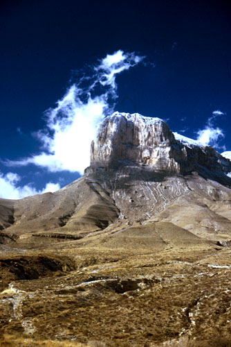
© Peter A. Scholle, 1999
Thin-bedded Cherry Canyon Formation exposed on right. Excellent views of El Capitan from this area. |
| 1.0 | 105.2 | 54.2 | Rest area on left. |
| 0.4 | 105.6 | 53.8 | Fault zone. Graded carbonate beds are present in the Cherry Canyon Formation at this locality. |
| 0.7 | 106.3 | 53.1 | Crest of Guadalupe Pass (elevation 1,736m; 5,695 ft). Pine Springs Canyon and the new Guadalupe Mountains National Park Visitor's Center are visible to the left -- excellent trails lead from here to the top of Guadalupe Peak, El Capitan, and other scenic and geologically interesting sites. The former site of the Pine Springs camp and gas station is just ahead on the right, along with the remarkably unattractive National Park Service housing tract. The Guadalupe Mountains National Park opened in 1972. In 1978 approximately 60 percent of the park was designated as wilderness area, precluding any large-scale development. The establishment of the park resulted, in large part, from the concern and generosity of Wallace Pratt, one of the first geologists of the original Humble Oil and Refining Co. (later Exxon), who lived for many years in the McKittrick Canyon area. Pratt first saw the area in 1921 and by 1937 had amassed a 16,000 acre ranch. Pratt's gift to the government of 5,632 acres of land, mainly in and around McKittrick Canyon, was the first concrete step toward the formation of this park. He also donated his home ("Ship on the Desert") and a stone cabin in McKittrick Canyon. Additional land was purchased from J. C. Hunter and other ranchers, so that the park currently includes 86,416 acres. The cliffs to the left (10:00 o'clock) are composed of Guadalupian basinal facies from the base to the middle of the slope; that is overlain by a thick zone of fore-reef rubble which, in turn, is capped by a thin zone of preserved reef limestone. The Getaway Limestone is visible in hills on the right and overlying sediments of the Cherry Canyon Formation are present in the slopes ahead and to the left. The greenish outcrops in these slopes (for example on Nipple Hill, directly ahead) are intercalated bentonite beds (volcanic ash) and silty shales in the Manzanita Limestone Member of the Cherry Canyon Formation. U. S. Highway 62-180 is still cut through the extensively faulted zone on the western side of the Guadalupe and Delaware Mountains. Numerous small faults are present here, as they have been in most of the outcrops we have passed in the last 15 to 25 km (10 to 15 mi). The remaining of a way-station of short-lived Butterfield Overland Mail route are located behind the Texas Highway Department garage on the left. As with other parts of this route, the station was abandoned in 1859, but not before supplying some exciting stagecoach rides through Guadalupe Pass. Route engineers built a rough, unpaved road down the pass, using a route close to the one followed by the later U. S. Highway 62-180. Waystations such as this one provided changes of horses (or mules in this area) as well as very brief (20 minute) meal stops for drivers and passengers (Adams, 1988). |
| 1.3 | 107.6 | 51.8 | Guadalupe Mountains National Park Frijole Station on the left. |
| 1.3 | 108.9 | 50.5 | Exposures of Cherry Canyon Formation sandstone; this section is just below the South Wells Limestone Member. |
| 0.8 | 109.7 | 49.7 | Quaternary fanglomerates in roadcuts. |
| 0.5 | 110.2 | 49.2 | Roadcuts in Cherry Canyon Formation. The South Wells Limestone Member is present at the top of this exposure and consists of thin-bedded sandstone and thin, lenticular, brachiopod-bearing limestones. The limestone beds range in thickness from 10 centimeters to a meter (4 in to 3 ft) and are generally micritic. The intercalation of thin limestones and sandstones tends to lower the erosional resistance of this unit and therefore it does not form a prominent scarp. This is not true of the other limestone members of the Cherry Canyon Formation, however. |
| 1.0 | 111.2 | 48.2 | We are descending off the Rader Ridge. The ridge is capped by the Rader Limestone Member of the Bell Canyon Formation (the third named member up from the base of the formation). We are now, once again, passing through the upper part of the Cherry Canyon Formation. |
| 0.2 | 111.4 | 48.0 | Nickle Creek Exxon Station on the left. The pale greenish, bentonitic beds of the Manzanita Limestone Member are visible at 11:00 o'clock, about half way up the hill. Overlying limestones are the Hegler and Pinery members of the Bell Canyon Fm. |
| 0.8 | 112.2 | 47.2 | Roadcut in Manzanita Limestone. The Manzanita is between 30 and 45 m (100 and 150 ft) thick in this area. This unit, part of the Cherry Canyon Fm., predates formation of the Capitan reef and thus passes under most of the mountain section to the west. The unit probably correlates with the upper part of the Queen Fm. on the shelf and the Goat Seep reef at the shelf margin. Manzanita, by the way, means "little apple" in Spanish and the unit was named for a red-barked tree we will see at a number of stops on the trip. Unfortunately the tree was misidentified and really is a Texas madrone (Arbutus texana, a heath which is related to the manzanitas (Reid et al., 1988). |
| 0.3 | 112.5 | 46.9 | STOP II-4. Rader submarine slide. Click on stop name to see locality description. BE CAREFUL TRAFFIC IS ESPECIALLY HAZARDOUS AT THIS OUTCROP! |
| 0.1 | 112.6 | 46.8 | Roadcuts in Rader Limestone. |
| 0.5 | 113.1 | 46.3 | STOP II-5. Bell Canyon Formation sandstones. Click on stop name to see locality description. |
| 0.7 | 113.8 | 45.6 | Entrance to McKittrick Canyon day-use area of the Guadalupe Mountains National Park on the left. See McKittrick Canyon supplementary roadlog and the associated Stop II-1 (McKittrick Canyon Permian Reef trail) description for information about this area. |
| 0.1 | 113.9 | 45.5 | The escarpment ahead is formed by the Lamar Limestone Member of the Bell Canyon Formation. |
| 1.0 | 114.9 | 44.5 | STOP II-6. Lamar Limestone Member basinal carbonates. Click on stop name to see locality description. |
| 1.2 | 116.1 | 143.0 | Roadside rest area on right. Excellent exposures of reef and fore-reef deposits can be seen to the southwest. The exposed part of the reef becomes progressively older toward the south. The crest of the reef at the southern end of its outcrop (near Guadalupe Peak) is approximately 300 m (1,000 ft) lower stratigraphically than the reef exposed at Walnut Canyon, about 40 km (25 mi) to the north of this location. This implies that the face of the reef has been eroded back by at least 0.8 km (1/2 mi) in the southern Guadalupe Mountains region. There is still some scientific dispute about the nature of the transition from shelf to basin along the Guadalupe Mountain front. Hayes and Gale (1957) and Hayes (1964) mapped the mountain front zone without any faulting. Kelley (1971; 1972), on the other hand, placed a fault with an estimated 60-120 m (200-400 ft) displacement along the front. |
| 7.9 | 124.0 | 35.4 | Straight ahead lies the solution escarpment of the Castile evaporites. We are driving on a surface of Quaternary gravels which lie on the basal limestone and shale unit of the Castile and on the Lamar Limestone. |
| 1.4 | 125.4 | 34.0 | Junction with Texas Ranch Road 652 on the right. Continue straight ahead. |
| 0.1 | 125.5 | 33.9 | Texas-New Mexico state line. Welcome to New Mexico. |
| 1.6 | 127.1 | 32.3 | Notice the difference in vegetation on the gravel surface on which we are now driving versus that on the hills of Castile gypsum and anhydrite directly ahead. |
| 0.5 | 127.6 | 31.8 | STOP II-7. Castile Formation Ochoan evaporites. Click on stop name to see locality description. |
| 1.9 | 129.5 | 29.9 | Note hummocky, solution-generated topography on top of the Castile evaporite. These are the Yeso Hills. |
| 1.1 | 130.6 | 28.8 | White's City visible directly ahead in the distance. The valley to the left is developed on the uppermost Bell Canyon strata (Lamar and post-Lamar beds). The Capitan reef escarpment can be seen plunging to the north beneath Ochoan and younger sediments as a consequence of structural tilting. To the south, the reef rises higher and higher on the skyline to the point where it has been removed by erosion. The buildings at the entrance to Carlsbad Caverns can be seen on the ridge top at about 11:00 o'clock. |
| 0.2 | 130.8 | 28.6 | Dirt road on right leads to a small quarry in the Castile evaporite — here, the gypsum has been very coarsely recrystallized and yields beautiful crystals, many over a foot across. |
| 1.0 | 131.8 | 27.6 | Zone of Quaternary rubble probably derived from dissolution of upper Castile or Salado evaporites. Several thin, weathered, basaltic igneous dikes cut the evaporite section in this area. |
| 1.4 | 133.2 | 26.2 | Roadside rest area on left. |
| 1.2 | 134.4 | 25.0 | At a point approximately 90 m (300 ft) east of the highway, loose boulders of Lower Cretaceous (Commanchean) limestone have been described by W. B. Lang (1937) who interpreted them as fragments of widespread Cretaceous cover down-dropped and preserved in solution pipes cut into the Ochoan evaporites. |
| 1.5 | 135.9 | 23.5 | Entrance road to Slaughter and Rattlesnake Canyons and New Cave on left. Both Rattlesnake and Slaughter Canyon have excellent exposures of the late Guadalupian Capitan fore-reef, reef, and back-reef facies (see Pray and Esteban, 1977). The view from the south wall of Slaughter Canyon (where the entrance to New Cave is located) to the north wall provides an excellent view of the progradation (and up-building) of reef and back-reef facies in the upper Capitan. Continue straight ahead. |
| 0.3 | 136.2 | 23.2 | Highway is still on Castile Formation. The mouth of Slaughter Canyon is visible at about 8:00 o'clock; the mouth of Rattlesnake Canyon can be seen at about 9:00 o'clock. The northwest-southeast trending Huapache Monocline crosses the Capitan reef front between these two canyons. |
| 1.8 | 138.0 | 21.4 | Quaternary gravel in roadcut. |
| 3.3 | 141.3 | 18.1 | Beautiful downtown White's City. Junction with New Mexico Highway 7 to Walnut Canyon and Carlsbad Caverns on left. See separate Walnut Canyon supplementary road log for information on reef and back-reef localities in this canyon that leads up to Carlsbad Caverns. Continue on U.S. Highway 62-180 to Carlsbad, New Mexico. |
| 5.0 | 146.3 | 13.1 | Bridge over Jurnigan Draw. Rustler Formation red beds can be seen in middle distance on right. |
| 0.2 | 146.5 | 12.9 | Junction with New Mexico Highway 396 on right. The Black River oil field is located to the right; the field produces 42 API gravity oil from sandstones and siltstones just beneath the Lamar Limestone member of the Bell Canyon Formation at about 600 m (1,950 ft) depth. The hills to the left are composed of Capitan reef limestone. Most production in this area that is nearer to the highway, however, is from Pennsylvanian units. |
| 1.5 | 148.0 | 11.4 | Roadcut in Rustler Formation. |
| 0.7 | 148.7 | 10.7 | Roadcut in Rustler Formation. |
| 2.6 | 151.3 | 8.1 | Junction with Dark Canyon Road on left near the Dark Canyon Antiques and General Store building. The hills to the west are composed of Tansill Formation near-back-reef limestones and dolomites. The one well Dark Canyon oil field lies about 0.8 km (1/2 mi) to the west. Completed in 1952, the field produced from a 3.3 m (11 ft) pay zone in Delaware Mountain sandstone at 572 m (1,876 ft) depth. The well continued to produce for many years at 10 to 12 BOPD. Continue straight ahead for Carlsbad. See supplementary Dark Canyon-Sitting Bull Falls-Rocky Arroyo roadlog for route to left. |
| 1.0 | 152.3 | 7.1 | In the foreground to the left are the Frontier Hills composed of Ochoan Rustler Formation sediments which dip southeastward into the Delaware basin. The Rustler Formation in this area consists of dolomite, red beds, fine-grained sandstones, and minor gypsum. The Rustler overlies the Salado Formation in the Delaware basin but lies directly on the Capitan Limestone in the ridge west of the Frontier Hills. |
| 1.8 | 154.1 | 5.3 | Carlsbad city limit. The town was started in 1888 (originally named Eddy after its founder, it was renamed Carlsbad in 1899). Charles Eddy, by the way, also founded Cloudcroft and Alamogordo, towns in or near the Sacramento Mountains to the northwest. The town of Eddy was sited here because of the Pecos river and the agricultural potential along its flood plain, although the mineral springs along the river eventually also led to a significant tourist industry. The town has since become an important county seat, a center for the regional potash mining industry, a significant tourist area (due to its proximity to Carlsbad Caverns), and a base for WIPP site operations (an experimental facility for disposal of low-level, government-generated, radioactive wastes). |
| 1.3 | 155.4 | 4.0 | Quaternary caliche exposed in pits on right. |
| 0.4 | 155.8 | 3.6 | Caverns City Air Terminal (Carlsbad municipal airport) entrance on left. The Hackberry Hills to the west are composed mainly of Tansill dolomites and upper Yates dolomites and sandstone both back-reef facies equivalents of the upper part of the Capitan reef. The reef itself is completely buried beneath younger sediments in this area. The back-reef equivalents are exposed only because of the gentle (approximately 5 degree) eastward dip of the Guadalupian strata in this area. |
| 2.5 | 158.3 | 1.1 | Roadway Inn on right. |
| 0.3 | 158.7 | 0.7 | Ocotillo Hills located to the northeast. |
| 0.7 | 159.4 | 0.0 | Junction with U.S. Highway 285 to Pecos, Texas on the right. Road log ends. |


