


Permian Reef Complex Virtual Field Trip
Stop III-1: Capitan/Tansill Reef to Back Reef Transition
We are a research and service division of:
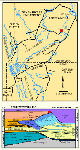
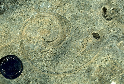
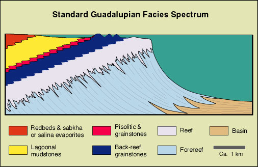
We will examine the reef to near-back-reef transition in the uppermost part of the Capitan and lower Tansill Formations. These sediments have been mapped as reefal Capitan limestones by Motts (1962a) and as back-reef limestones of the Tansill Formation by Kelley (1971). Tyrrell (1969) and Toomey and Cys (1977) presented extensive evidence to show that this locality provides an exposure of the transition beds between the Capitan and Tansill carbonates. Clearly, the major part of the reef front is buried beneath basinal sediments in this area but some reefal or patch reef deposits are still visible. You should be able to see a wide variety of fossils (or at least you could before the outcrop was vandalized, reportedly by University of Nebraska graduate students). Among other features, calcareous sponges, Archaeolithoporella (a possible red algal encruster), Tubiphytes "thickets" and encrustations, Collenella (a possible hydrocoral or stromatoporoid) mounds or clusters, marine cements andmarine-cemented fractures are present in the reef zone. More shelfal or intermound deposits are also exposed, and you should be able to examine near-back-reef skeletal grainstones containing ooids and algally coated grains, dasycladacean green algae (particularly Mizzia and Macroporella), articulate crinoids (including stems, holdfasts, calyxes, and cirri; see photo), calcitic belerophontid gastropods (see photo), aragonitic (moldic) gastropods and pelecypods, fusulinid Foraminifera, localized Tubiphytes-Archaeolithoporella colonies, and sponges (see diagram below). These rocks are similar in many ways to the sediments seen at the up-canyon end of the first stop in Walnut Canyon ( Stop I-2) which would indicate that we are probably at, or only a short distance shelfward, of the main reef facies. Note the consistent change in bedding character as we walk in a shelfward direction.

© Peter A. Scholle, 1999
© Peter A. Scholle, 1999
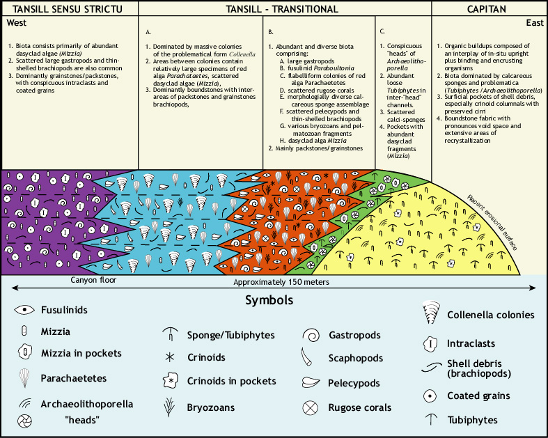
The abruptness of the facies transition seen here and in Walnut Canyon in the near-back reef setting is very similar to modern facies transitions in areas such as Florida or the Bahamas. There, as here, reefal debris tends to move primarily into fore-reef talus; back-reef sands are dominated by grains of green algal origin (Halimeda in modern sediments; Mizzia in the Permian) ooids or coated grains, and other particles of shelf origin. Submarine shoals, channels, islands, and patch reefs have local distribution and complex, virtually unpredictable, patterns. Such modern setting appear to be excellent analogs for these older environments.
© Peter A. Scholle, 1999
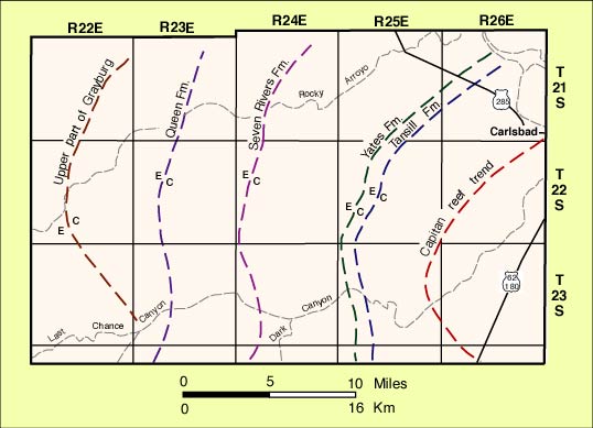
We will not be able to stay within the Tansill Formation in our entire traverse through the Capitan-equivalent shelf strata because erosion has removed much of the far-back-reef Tansill. We will see facies equivalents in older (but still Capitan-equivalent) strata of the Yates and Seven Rivers Formations. Evidence from remaining outcrops and subsurface data indicate that similar shelfward facies transitions occurred in all three back-reef units (see diagram). The general sequence of facies from the shelf-edge landward (see diagram) tends to be reef; massive skeletal (mainly green algal) grainstones; bedded and cross-bedded oolitic grainstones; dolomitized, fenestral grainstones and pisolitic mudstones; coarse, pisolitic, dolomitized grainstones with tepee structures; stromatolitic or peloidal dolomitized mudstones; pure, calcisphere-bearing, dolomitic mudstones; with evaporite crystal casts and (or) collapse breccias; nodular gypsum or anhydrite units; and finally red siltstones.
Throughout this facies suite, thin but laterally persistent, fine-grained sandstone and siltstone beds are found. These sandstone-siltstone units, especially common in the Yates Formation, generally pinch out before reaching the reef facies; in several areas these sandstones approach within a few hundred meters of the reef. In the Yates (and the older Queen) strata, these terrigenous beds make up at least 1/3 of the formation thickness, are excellent regional correlation markers, and can act as reservoir units.
Because there was extensive (3-5 km; 2-3 mi) basinward progradation of facies during the Capitan deposition, the facies previously described as being lateral equivalents can also be seen to some degree in vertical sequence, a fact which has significant influence on the early diagenetic history of much of the sediment package. The progressive basinward shift of the evaporite-carbonate transition zones in successively younger, Capitan-equivalent, back-reef units is clear from the diagram shown earlier (see diagram above). Thus, the progradation of shallow-water, subaerial, or restricted environments over more normal marine sections may have allowed very early input of freshwater or hypersaline brines into unconsolidated and geochemically unstable sediments. Indeed, sediments from the shelfward edge of this outcrop to the platform interior show extensive signs of vadose as well as phreatic leaching and cementation combined with virtually complete, very finely crystalline dolomite replacement. The approximate thickness of back reef units of the Artesia Group in this region are (in ascending order): Grayburg Fm., 120-150 m (400-500 ft); Queen Fm., 60-150 m (200-400 ft); Seven Rivers Fm., 135-180 m (450-600 ft); Yates Fm., 90-150 m (300-400 ft); and Tansill Fm., 30-100 m (100-325 ft )(all data from Kelley, 1971). The transitions from carbonate to evaporite facies generally occur within 8-24 km (5 to 15 mi) shelfward of the bank margin or reef throughout the history of the Artesia Group.
Numerous grinding holes (metates) of the Mescalero Apache are found at several sites in this area, indicating that it was a region populated long before historical times.
Turn around and return to the main road.
Return to Dark Canyon-Sitting Bull Falls-Rocky Arroyo Roadlog