


Permian Reef Complex Virtual Field Trip
Stop I-1: West Face of Guadalupe & Delaware Mountains
We are a research and service division of:
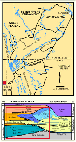
This location provides an excellent view of the Guadalupe and Delaware Mountains and the Salt Flat Bolson (in which we are now standing). We can see a magnificent panorama including the Upper Permian section of the Guadalupe Mountains, about 32 km (20 mi) to the northeast. This 1,500 m (5,000 ft) escarpment is formed by a major north-south trending normal fault system which marks the eastern boundary of the Salt Flat Bolson. To the northwest and west we can see the Cornudas Mountains, Cerro Diablo, and Sierra Tinaja Pinta, a series of Tertiary igneous plugs and lava flows. To the south lies the Sierra Diablo range which is terminated by the Babb flexure zone, a monocline at its northern end. The Sierra Diablo range exposed mainly Leonardian Victorio Peak Fm. carbonates and older units. Upper Permian (Guadalupian) limestones and sandstones of the Cherry Canyon Formation compose the two mesas to the north of the Babb flexure. Also visible beyond these mesas is Sierra Prieta, an exhumed Oligocene nepheline syenite intrusive. Finally, to the southeast, Upper Permian strata, primarily Brushy Canyon Formation basinal sandstones, are visible in the elongate face of the Delaware Mountain escarpment.
© Peter A. Scholle, 1980 and 1992
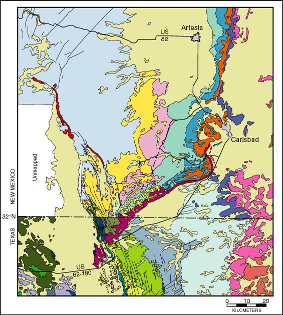
Because the Guadalupe Mountains are the major focus of this portion of the field trip, let us take a closer look at that range. Although the topography of the eastern side of the Guadalupe Mountains is almost entirely defined by the largely undeformed primary facies distribution of the Guadalupian sediments, the western face is completely controlled by Tertiary normal faults (see geologic map). Thus, on the western side, strata with a northeast-southwest facies strike are obliquely transected by a swarm of northwest-southeast or north-south trending faults. Furthermore, we are viewing the faulted exposure obliquely from our current vantage point, which makes accurate geologic observation even more difficult.
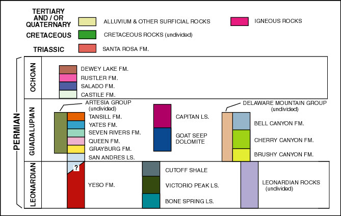
For reference purposes, let us name the major peaks on the Guadalupe Mountain skyline . From south to north these include the massif of El Capitan (elevation 2,462 m; 8,078 ft), Guadalupe Peak (the highest point in Texas at 2,667 m; 8,751 ft), Shumard Peak (about 2,545 m; 8,350 ft), an unnamed spur off Shumard Peak (about 2,545 m; 8,350 ft), Bartlett Peak (2,595; 8,513 ft), and Bush Mountain (2,644 m; 8,676 ft). The massive, light colored rocks, which compose the upper parts of El Capitan, Guadalupe, and Shumard Peaks, are Upper Permian (Guadalupian) Capitan limestones and dolomites (see diagrams below of the west face of the southern Gualalupe Mts. and Delaware basin stratigraphy). Most of this mass is thick-bedded, fore-reef talus (largely of Rader age) which dips steeply (up to 35 degrees) to the southeast, into the basinal sediments of the Delaware basin. The top of Guadalupe and nearby peaks, however, have true Capitan reef facies and even back-reef sediments. The Capitan reef and fore-reef strata undoubtedly once extended several kilometers further south in this region but have been trimmed back by subsequent erosion. To the north, Bartlett Peak is capped by the oldest exposed Capitan reef limestones which overlie rubble of an older (Goat Seep) reef. The area to the north of the Bush Mountain contains the main reef-massif of the Goat Seep as well as age equivalent back-reef calcarenites and terrigenous sandstones (Queen and Grayburg) which stand out clearly as vegetated zones on the mountain slope. "At Guadalupe Peak the smooth slopes below the Capitan are Cherry Canyon and Brushy Canyon sandstones. North of Shumard Peak, the upper part of the Cherry Canyon grades into Goat Seep reef. A tongue of Cherry Canyon sandstone continues northward under the Goat Seep reef and grades into small reefs and reefy lime banks in the southern Brokeoff Mountains, and into bedded back-reef rocks in the central Brokeoff Mountains. There Boyd has measured approximately 600 feet (180 m) of beds which he calls the San Andres Formation, and Frenzel, considers to be lower San Andres. . . "
"The rugged cliffs outcropping below the Delaware sand slopes are cut from the dark-bedded Bone Spring Limestone of Leonard age. Between El Capitan and Shumard Peak, the top of the Bone Spring Limestone rises over 1000 feet (300 m) and this defines the Bone Spring flexure described by King. Below Shumard Peak the upper part of the Bone Spring has changed to the gray Victorio Peak . . ., a reefy lime-bank facies. The Brushy Canyon sandstone onlaps the Bone Spring flexure and is absent in the slope below Bartlett Peak" (Anonymous, 1960, p. 50).
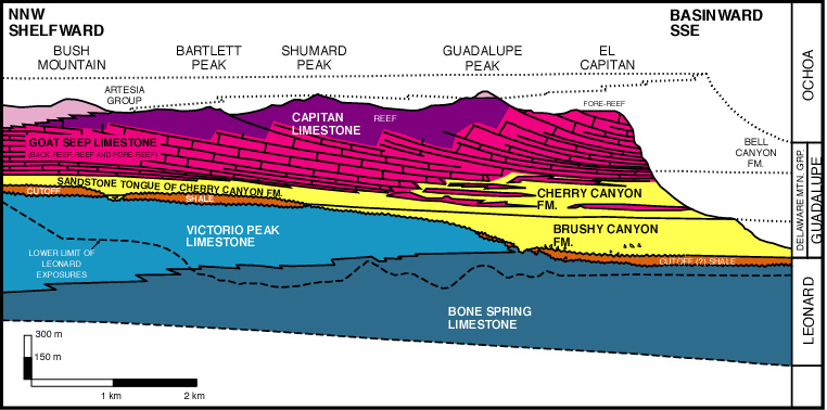
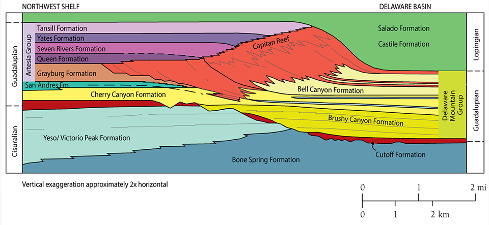
The bulk of the strata just described were considered to represent just two major phases of basinal progradational filling according to McDaniel and Pray (1967). The Victorio Peak Dolomite and the underlying Bone Spring Limestone form the older (Leonardian) phase. This sequence represents at least 3-5 km (2-3 mi) of basinal infilling and progradation of shelf facies during the accumulation of about 300 m (1,000 ft) of section (McDaniel and Pray, 1967). "The Leonardian bank margin was eroded in latest Leonardian and/or in early Guadalupian time, and a major transgression of basin facies dark carbonates (Cutoff shaly member of King) brought basinal environments far to the north, overlapping Leonardian basin, basin margin, and shelf deposits alike" (Pray, 1975, p. 5). Presumably this transgression was a consequence either of major regional subsidence or of eustatic sea level rise. This transgression was followed by the second major cycle of progradation, represented by Goat Seep and Capitan reef complexes. These units built the Guadalupian shelf edge outward several miles by filling in a basin of 300 to 550 m (1,000 to 1,800 ft) depth with steeply dipping, reef-derived debris beds which are clearly visible at the southern end of the Guadalupe escarpment. It is the upper part of this progradational sequence which will occupy much of our attention on this trip.
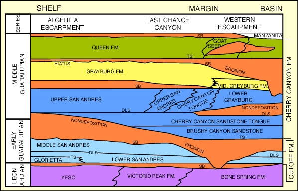
More recent work on outcrops and seismic data by Franseen (1989), Pray (1988a; 1988b), Crawford (1988); Sarg (1985), Sarg and Lehmann (1986) has shown a somewhat more complicated picture (see schematic cross section). In these models, significant unconformities (sequence boundaries) are found both above and below the Cutoff Fm., erosional dissection is seen on the top of the Grayburg slope and shelf edge section, and another sequence boundary is interpreted to exist near the top of the Queen Fm. (see photos below). The nature of many of these unconformities, whether subaerial or submarine, is still being actively debated in the geologic literature.
All authors agree, however, that there is a major change in the nature of carbonate sedimentation visible in the upward progression of units. Carbonate sedimentation of the Victorio Peak, San Andres, and Grayburg strata was characterized by "ramp" development with an unbarred, gentle transition from shelf to basin (Pray, 1988b; Wilson, 1975). Younger units, on the other hand, show steep, reefal margins with slope angles up to 35°.
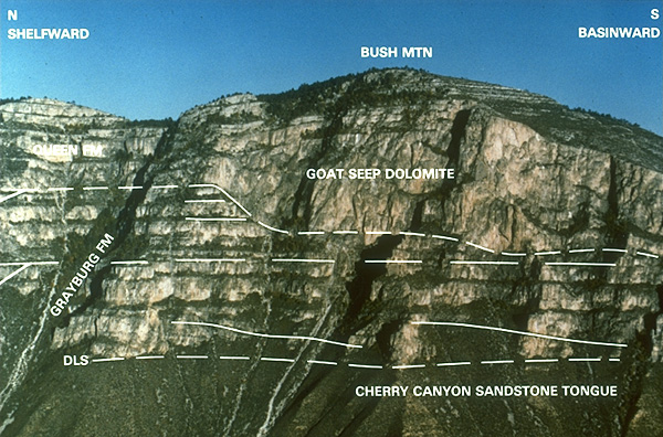
Photo courtesy of J.F. Sarg and Exxon Production Research Co.
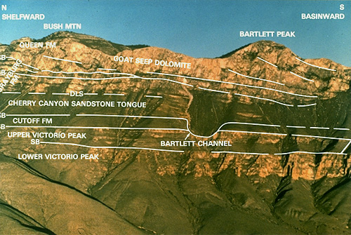
Photo courtesy of J.F. Sarg and Exxon Production Research Co.
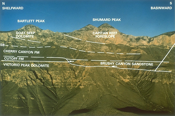
Photo courtesy of J.F. Sarg and Exxon Production Research Co.