


Permian Reef Complex Virtual Field Trip
Stop III-3: Tansill-Yates Transition Facies
We are a research and service division of:
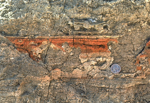
The Tansill-Yates contact is exposed in the western part of the outcrop, marked by a thin sandstone-siltstone unit. We can see algally laminated dolomites, fusulinid grainstones, pisolitic beds, probable Permian breccia pipes, as well as infiltrated, red, lateritic soils in solution-enlarged fractures and voids (see photo). The pisolitic microfacies was postulated by Dunham (1972) to be one of the highest paleotopographic zones in the Capitan complex. Pisolitic "caliche" zones and solution features would thus be a probable result of even minor relative sea level drops during deposition. The red void-fillings consist of kaolinite, hematite, quartz, goethite, illite, and amorphous iron oxide, a reasonable composition for a solution residue in this area.
© Peter A. Scholle, 1999
Some arguments can be presented against this scenario, however. The associated sandstone-siltstone beds show no thinning over this zone) as one might expect if this were a topographic "high". Furthermore, topographic highs are rarely sites of significant accretionary sedimentation and, in fact, caliches are typically dissolution facies not accretionary ones. Scholle and Kinsman (1974) described some accretionary coastal caliche from the Persian (Arabian) Gulf, but the salina seep hypothesis of Handford et al. (1984) appears to account for the observed relationships better than any of the other models.
The thin sandstone-siltstone bed at the Yates-Tansill contact is typical of such terrigenous units in this area. They are generally 0.3-2.5 m (1-8 ft) thick, well-sorted, very fine sandstone or coarse siltstone, and have subarkosic or arkosic composition. Dunham (1972) showed that a progressive decrease in feldspar content of these units from shelf interior to the Capitan shelf margin is directly matched by a progressive increase in kaolinite content. Thus, these clastic terrigenous beds were probably uniformly arkosic but the near-reef sections underwent more intense post-depositional alteration.
In spite of their relative thinness, these sandstone-siltstone beds have great lateral extent (up to 100,000 mi2), particularly parallel to the reef trend, and serve as excellent stratigraphic marker beds (DeFord and Riggs, 1941). Some low-angle channel structures and ripples can be seen, locally, in these units, but generally these sediments are horizontally laminated or structureless. They presumably represent largely wind-transported material; the horizontal lamination may have resulted from dune migration over an equilibrium deflation surface (sabkha) or from deposition in shallow, lagoonal waters.
Fuller discussion of these relationships may be found in the introduction and the description for Stop I-4.
Return to Dark Canyon-Sitting Bull Falls-Rocky Arroyo Roadlog